Shahbā elevation
Shahbā (As-Suwayda), Syria elevation is 1083 meters and Shahbā elevation in feet is 3553 ft above sea level [src 1]. Shahbā is a seat of a second-order administrative division (feature code) with elevation that is 554 meters (1818 ft) bigger than average city elevation in Syria.
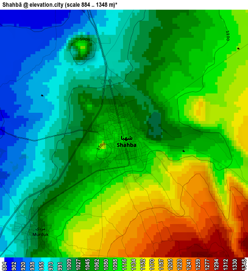
Below is the Elevation map of Shahbā, which displays elevation range with different colors. Scale of the first map is from 884 to 1348 m (2900 to 4423 ft) with average elevation of 1069 meters (=3507 ft) [note 1]
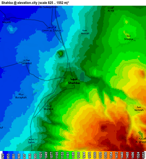
These maps also provides idea of topography and contour of this city, they are displayed at different zoom levels. More info about maps, scale and edge coordinates you can find below images.
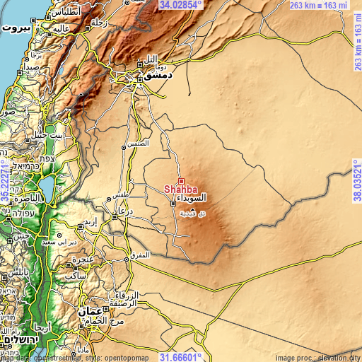
| \ | Map #1 | Map #2 | Topo.Map |
| Scale [m] | 884..1348 m | 825..1552 m | × |
| Scale [ft] | 2900..4423 ft | 2707..5092 ft | × |
| Average | 1069 m = 3507 ft | 1077.5 m = 3535 ft | × |
| Width | 8.21 km = 5.1 mi | 16.42 km = 10.2 mi | 262.7 km = 163.2 mi |
| Height | 8.21 km = 5.1 mi | 16.42 km = 10.2 mi | 262.7 km = 163.2 mi |
| ↑Max Latitude | 32.892048° | 32.928941° | 34.02854° |
| Latitude at center | 32.85514° | 32.85514° | 32.85514° |
| ↓Min Latitude | 32.818216° | 32.781277° | 31.66601° |
| ← Min Longitude | 36.585015° | 36.541069° | 35.22271° |
| Longitude center | 36.62896° | 36.62896° | 36.62896° |
| →Max Longitude | 36.672905° | 36.716851° | 38.03521° |
Nearby cities:
Cities around Shahbā sort by population:
• As-Suwayda elevation 1068 m
17.2 km,  198°
198°
• Al Ḩarāk 635 m
32.1 km,  248°
248°
• Izra‘ 581 m
35 km,  272°
272°
• Şalākhid 885 m
5.6 km,  290°
290°
• Mismīyah 618 m
37.5 km,  324°
324°
• Al Musayfirah 695 m
36.7 km,  227°
227°
• Al Qurayyā 1059 m
34.8 km,  184°
184°
• Aş Şūrah aş Şaghīrah 737 m
20.4 km,  345°
345°
• Al Mushannaf 1514 m
18.7 km,  133°
133°
• Al Mazra‘ah 800 m
16.3 km,  240°
240°
• ‘Arīqah 804 m
14.1 km, 285°
• Shaqqā 1193 m
7.9 km,  53°
53°
Multilingual:
 En español:
Shahbā elevación 1083 m.
 En France:
Shahbā élévation 1083 m.


Sources and notes:
- [note 1] Map square and city borders are not equal. Map elevation data is calculated only from area inside that square.
- [src 1] Elevation data from geonames database provided with same terms of usage.
- [src 2] The elevation map of Shahbā is generated using elevation data from NASA's 3 arcsec (90m) resolution SRTM data.
- [src 3] Base (background) map © OpenStreetMap contributors tiles are generated by Geofabrik and OpenTopoMap.
Copyright & License:
This Shahbā Elevation Map is licensed under CC BY-SA. You may reuse any part from this page, if you give a proper credit by linking to this URL:
 More info on terms of use page.