Jocoro elevation
Jocoro (Morazán), El Salvador elevation is 230 meters and Jocoro elevation in feet is 755 ft above sea level [src 1]. Jocoro is a populated place (feature code) with elevation that is 241 meters (791 ft) smaller than average city elevation in El Salvador.
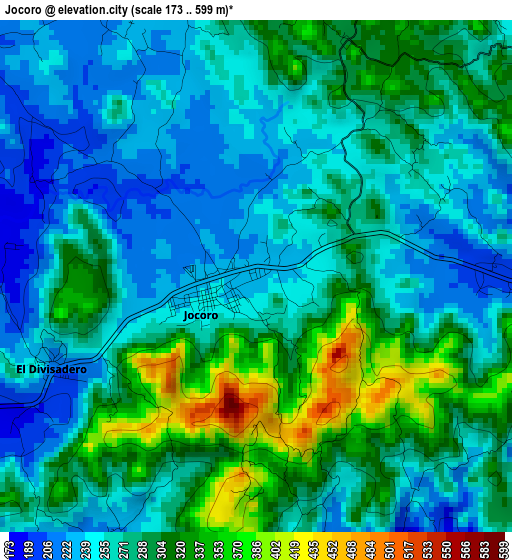
Below is the Elevation map of Jocoro, which displays elevation range with different colors. Scale of the first map is from 173 to 599 m (568 to 1965 ft) with average elevation of 277.6 meters (=911 ft) [note 1]
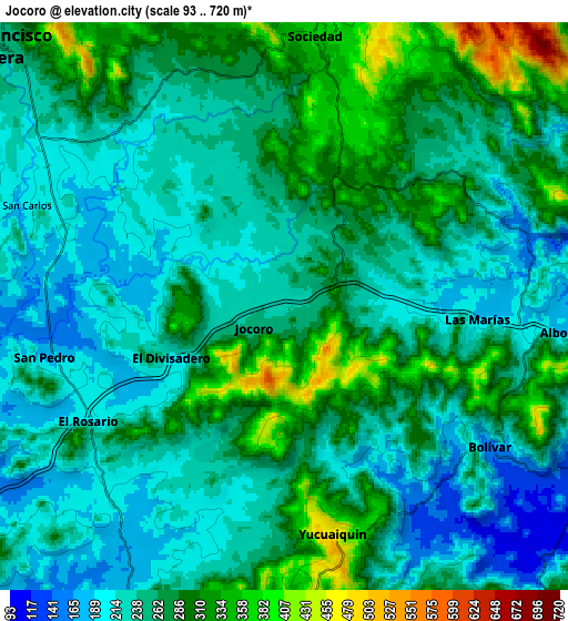
These maps also provides idea of topography and contour of this city, they are displayed at different zoom levels. More info about maps, scale and edge coordinates you can find below images.
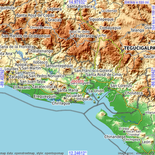
| \ | Map #1 | Map #2 | Topo.Map |
| Scale [m] | 173..599 m | 93..720 m | × |
| Scale [ft] | 568..1965 ft | 305..2362 ft | × |
| Average | 277.6 m = 911 ft | 259.6 m = 852 ft | × |
| Width | 9.5 km = 5.9 mi | 19 km = 11.8 mi | 303.9 km = 188.8 mi |
| Height | 9.5 km = 5.9 mi | 19 km = 11.8 mi | 303.9 km = 188.8 mi |
| ↑Max Latitude | 13.659376° | 13.702075° | 14.97932° |
| Latitude at center | 13.61667° | 13.61667° | 13.61667° |
| ↓Min Latitude | 13.573956° | 13.531234° | 12.24612° |
| ← Min Longitude | -88.060615° | -88.104561° | -89.42292° |
| Longitude center | -88.01667° | -88.01667° | -88.01667° |
| →Max Longitude | -87.972725° | -87.928779° | -86.61042° |
Nearby cities:
Cities around Jocoro sort by population:
• San Miguel elevation 130 m
23.3 km,  230°
230°
• San Francisco 270 m
12.9 km,  315°
315°
• Santa Rosa de Lima 96 m
13.3 km,  86°
86°
• Guatajiagua 288 m
20.6 km,  285°
285°
• San Alejo 177 m
21.4 km,  164°
164°
• Corinto 848 m
22.1 km,  12°
12°
• Anamorós 176 m
20.7 km,  48°
48°
• Nueva Esparta 289 m
26.7 km, 46°
• Cacaopera 636 m
18.2 km,  336°
336°
• Pasaquina 53 m
19.3 km,  100°
100°
• Moncagua 231 m
26.9 km,  249°
249°
• Sociedad 346 m
9.3 km,  0°
0°
Multilingual:
 En español:
Jocoro elevación 230 m.
 En France:
Jocoro élévation 230 m.


Sources and notes:
- [note 1] Map square and city borders are not equal. Map elevation data is calculated only from area inside that square.
- [src 1] Elevation data from geonames database provided with same terms of usage.
- [src 2] The elevation map of Jocoro is generated using elevation data from NASA's 3 arcsec (90m) resolution SRTM data.
- [src 3] Base (background) map © OpenStreetMap contributors tiles are generated by Geofabrik and OpenTopoMap.
Copyright & License:
This Jocoro Elevation Map is licensed under CC BY-SA. You may reuse any part from this page, if you give a proper credit by linking to this URL:
 More info on terms of use page.