Sensuntepeque elevation
Sensuntepeque (Cabañas), El Salvador elevation is 734 meters and Sensuntepeque elevation in feet is 2408 ft above sea level [src 1]. Sensuntepeque is a seat of a first-order administrative division (feature code) with elevation that is 263 meters (863 ft) bigger than average city elevation in El Salvador.
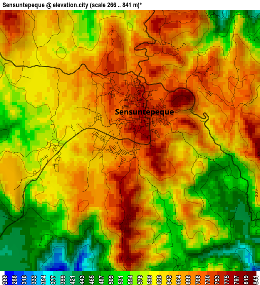
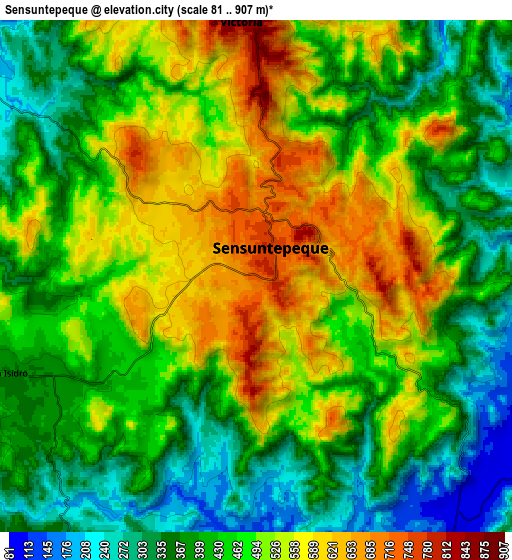
Below is the Elevation map of Sensuntepeque, which displays elevation range with different colors. Scale of the first map is from 266 to 841 m (873 to 2759 ft) with average elevation of 622.1 meters (=2041 ft) [note 1]
These maps also provides idea of topography and contour of this city, they are displayed at different zoom levels. More info about maps, scale and edge coordinates you can find below images.
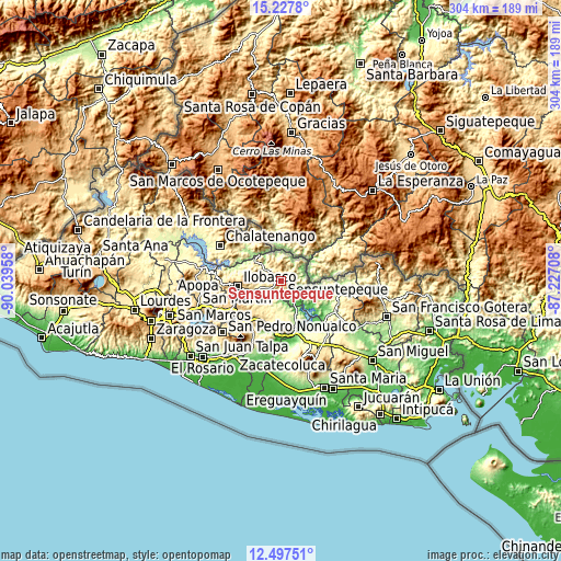
| \ | Map #1 | Map #2 | Topo.Map |
| Scale [m] | 266..841 m | 81..907 m | × |
| Scale [ft] | 873..2759 ft | 266..2976 ft | × |
| Average | 622.1 m = 2041 ft | 458.9 m = 1506 ft | × |
| Width | 9.49 km = 5.9 mi | 18.98 km = 11.8 mi | 303.6 km = 188.6 mi |
| Height | 9.49 km = 5.9 mi | 18.98 km = 11.8 mi | 303.6 km = 188.6 mi |
| ↑Max Latitude | 13.909331° | 13.951983° | 15.2278° |
| Latitude at center | 13.86667° | 13.86667° | 13.86667° |
| ↓Min Latitude | 13.824002° | 13.781325° | 12.49751° |
| ← Min Longitude | -88.677275° | -88.721221° | -90.03958° |
| Longitude center | -88.63333° | -88.63333° | -88.63333° |
| →Max Longitude | -88.589385° | -88.545439° | -87.22708° |
Nearby cities:
Cities around Sensuntepeque sort by population:
• Cojutepeque elevation 874 m
36.4 km,  242°
242°
• San Vicente 696 m
31.6 km,  214°
214°
• San Martín 622 m
32 km,  253°
253°
• Chalatenango 406 m
37.3 km,  299°
299°
• Berlín 975 m
42.2 km,  165°
165°
• Ciudad Barrios 847 m
41.1 km,  105°
105°
• San Sebastián 690 m
26.2 km, 235°
• Apastepeque 623 m
27.5 km,  216°
216°
• Tecoluca 758 m
41.1 km,  257°
257°
• Victoria 879 m
9.3 km,  0°
0°
• Sesori 184 m
33.3 km,  120°
120°
• Tenancingo 617 m
38 km, 264°
Multilingual:
 En español:
Sensuntepeque elevación 734 m.
 En France:
Sensuntepeque élévation 734 m.
 Auf Deutsch:
Sensuntepeque höhe über dem Meeresspiegel ist 734 m.

Sources and notes:
- [note 1] Map square and city borders are not equal. Map elevation data is calculated only from area inside that square.
- [src 1] Elevation data from geonames database provided with same terms of usage.
- [src 2] The elevation map of Sensuntepeque is generated using elevation data from NASA's 3 arcsec (90m) resolution SRTM data.
- [src 3] Base (background) map © OpenStreetMap contributors tiles are generated by Geofabrik and OpenTopoMap.
Copyright & License:
This Sensuntepeque Elevation Map is licensed under CC BY-SA. You may reuse any part from this page, if you give a proper credit by linking to this URL:
 More info on terms of use page.