Berbera elevation
Berbera (Woqooyi Galbeed), Somalia elevation is 11 meters and Berbera elevation in feet is 36 ft above sea level [src 1]. Berbera is a populated place (feature code) with elevation that is 279 meters (915 ft) smaller than average city elevation in Somalia.
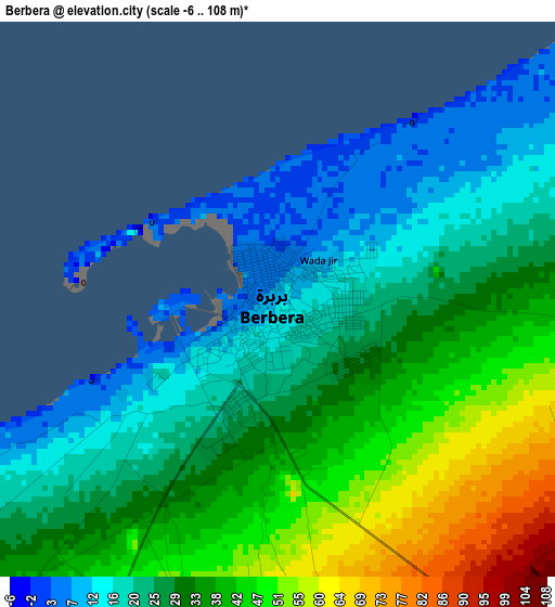
Below is the Elevation map of Berbera, which displays elevation range with different colors. Scale of the first map is from -6 to 108 m (-20 to 354 ft) with average elevation of 31.2 meters (=102 ft) [note 1]
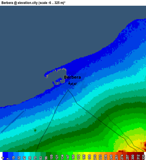
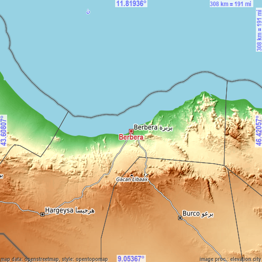
These maps also provides idea of topography and contour of this city, they are displayed at different zoom levels. More info about maps, scale and edge coordinates you can find below images.
| \ | Map #1 | Map #2 | Topo.Map |
| Scale [m] | -6..108 m | -6..325 m | × |
| Scale [ft] | -20..354 ft | -20..1066 ft | × |
| Average | 31.2 m = 102 ft | 66.7 m = 219 ft | × |
| Width | 9.61 km = 6 mi | 19.22 km = 11.9 mi | 307.5 km = 191.1 mi |
| Height | 9.61 km = 6 mi | 19.22 km = 11.9 mi | 307.5 km = 191.1 mi |
| ↑Max Latitude | 10.482805° | 10.526014° | 11.81936° |
| Latitude at center | 10.43959° | 10.43959° | 10.43959° |
| ↓Min Latitude | 10.396369° | 10.353142° | 9.05367° |
| ← Min Longitude | 44.970375° | 44.926429° | 43.60807° |
| Longitude center | 45.01432° | 45.01432° | 45.01432° |
| →Max Longitude | 45.058265° | 45.102211° | 46.42057° |
Nearby cities:
Cities around Berbera sort by population:
• Hargeysa elevation 1261 m
142.7 km,  226°
226°
• Burao 1041 m
116.8 km,  150°
150°
• Laascaanood 692 m
337.3 km,  130°
130°
• Ceerigaabo 1786 m
258 km,  85°
85°
• Baki 1481 m
188.4 km,  251°
251°
• Las Khorey 6 m
356.7 km,  77°
77°
• Oodweyne 1055 m
114.7 km,  177°
177°
• Ceek 865 m
164.5 km,  166°
166°
• Baligubadle 1331 m
194.9 km,  214°
214°
• Lughaye 9 m
120.2 km,  283°
283°
Multilingual:
 En español:
Berbera elevación 11 m.
 En France:
Berbera élévation 11 m.


Sources and notes:
- [note 1] Map square and city borders are not equal. Map elevation data is calculated only from area inside that square.
- [src 1] Elevation data from geonames database provided with same terms of usage.
- [src 2] The elevation map of Berbera is generated using elevation data from NASA's 3 arcsec (90m) resolution SRTM data.
- [src 3] Base (background) map © OpenStreetMap contributors tiles are generated by Geofabrik and OpenTopoMap.
Copyright & License:
This Berbera Elevation Map is licensed under CC BY-SA. You may reuse any part from this page, if you give a proper credit by linking to this URL:
 More info on terms of use page.