Hargeysa elevation
Hargeysa (Woqooyi Galbeed), Somalia elevation is 1261 meters and Hargeysa elevation in feet is 4137 ft above sea level [src 1]. Hargeysa is a seat of a first-order administrative division (feature code) with elevation that is 971 meters (3186 ft) bigger than average city elevation in Somalia.
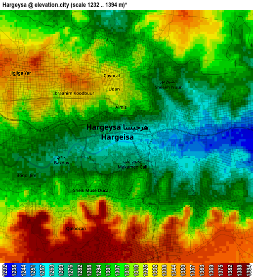
Below is the Elevation map of Hargeysa, which displays elevation range with different colors. Scale of the first map is from 1232 to 1394 m (4042 to 4573 ft) with average elevation of 1310.1 meters (=4298 ft) [note 1]
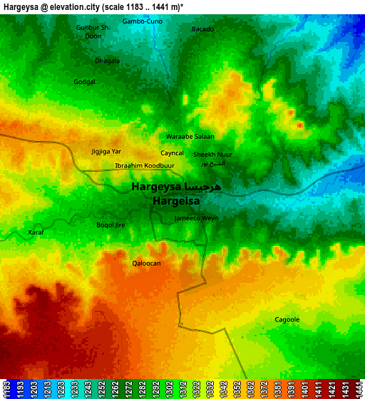
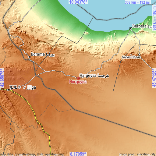
These maps also provides idea of topography and contour of this city, they are displayed at different zoom levels. More info about maps, scale and edge coordinates you can find below images.
| \ | Map #1 | Map #2 | Topo.Map |
| Scale [m] | 1232..1394 m | 1183..1441 m | × |
| Scale [ft] | 4042..4573 ft | 3881..4728 ft | × |
| Average | 1310.1 m = 4298 ft | 1310.2 m = 4299 ft | × |
| Width | 9.64 km = 6 mi | 19.27 km = 12 mi | 308.3 km = 191.6 mi |
| Height | 9.64 km = 6 mi | 19.27 km = 12 mi | 308.4 km = 191.6 mi |
| ↑Max Latitude | 9.603332° | 9.646659° | 10.94376° |
| Latitude at center | 9.56° | 9.56° | 9.56° |
| ↓Min Latitude | 9.516662° | 9.473319° | 8.17059° |
| ← Min Longitude | 44.021055° | 43.977109° | 42.65875° |
| Longitude center | 44.065° | 44.065° | 44.065° |
| →Max Longitude | 44.108945° | 44.152891° | 45.47125° |
Nearby cities:
Cities around Hargeysa sort by population:
• Berbera elevation 11 m
142.7 km,  46°
46°
• Burao 1041 m
161.1 km,  91°
91°
• Laascaanood 692 m
381.3 km,  108°
108°
• Ceerigaabo 1786 m
380.2 km,  72°
72°
• Baki 1481 m
83.1 km,  296°
296°
• Oodweyne 1055 m
110.8 km,  98°
98°
• Ceek 865 m
155 km, 113°
• Lughaye 9 m
125.9 km,  353°
353°
• Baligubadle 1331 m
62.7 km,  186°
186°
Multilingual:
 En español:
Hargeysa elevación 1261 m.
 En France:
Hargeysa élévation 1261 m.
 Auf Deutsch:
Hargeysa höhe über dem Meeresspiegel ist 1261 m.

Sources and notes:
- [note 1] Map square and city borders are not equal. Map elevation data is calculated only from area inside that square.
- [src 1] Elevation data from geonames database provided with same terms of usage.
- [src 2] The elevation map of Hargeysa is generated using elevation data from NASA's 3 arcsec (90m) resolution SRTM data.
- [src 3] Base (background) map © OpenStreetMap contributors tiles are generated by Geofabrik and OpenTopoMap.
Copyright & License:
This Hargeysa Elevation Map is licensed under CC BY-SA. You may reuse any part from this page, if you give a proper credit by linking to this URL:
 More info on terms of use page.