Ceelbuur elevation
Ceelbuur (Galguduud), Somalia elevation is 153 meters and Ceelbuur elevation in feet is 502 ft above sea level [src 1]. Ceelbuur is a populated place (feature code) with elevation that is 137 meters (449 ft) smaller than average city elevation in Somalia.
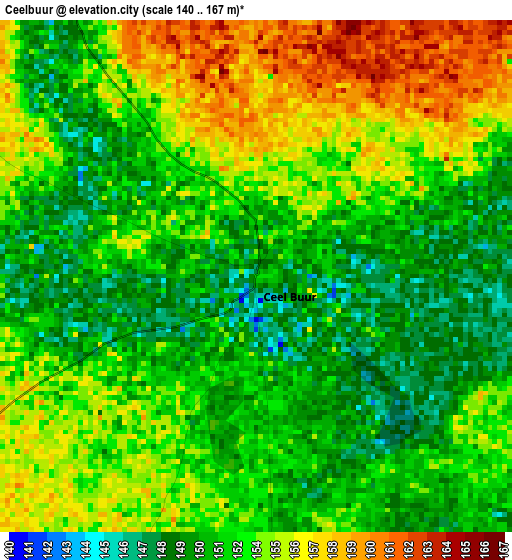
Below is the Elevation map of Ceelbuur, which displays elevation range with different colors. Scale of the first map is from 140 to 167 m (459 to 548 ft) with average elevation of 152.8 meters (=501 ft) [note 1]
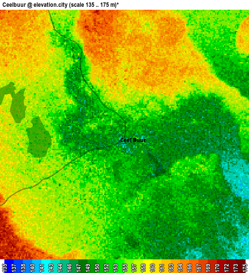
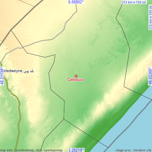
These maps also provides idea of topography and contour of this city, they are displayed at different zoom levels. More info about maps, scale and edge coordinates you can find below images.
| \ | Map #1 | Map #2 | Topo.Map |
| Scale [m] | 140..167 m | 135..175 m | × |
| Scale [ft] | 459..548 ft | 443..574 ft | × |
| Average | 152.8 m = 501 ft | 154.9 m = 508 ft | × |
| Width | 9.74 km = 6.1 mi | 19.48 km = 12.1 mi | 311.6 km = 193.6 mi |
| Height | 9.74 km = 6.1 mi | 19.48 km = 12.1 mi | 311.7 km = 193.7 mi |
| ↑Max Latitude | 4.728807° | 4.772601° | 6.08502° |
| Latitude at center | 4.68501° | 4.68501° | 4.68501° |
| ↓Min Latitude | 4.64121° | 4.597408° | 3.28219° |
| ← Min Longitude | 46.573655° | 46.529709° | 45.21135° |
| Longitude center | 46.6176° | 46.6176° | 46.6176° |
| →Max Longitude | 46.661545° | 46.705491° | 48.02385° |
Nearby cities:
Cities around Ceelbuur sort by population:
• Beledweyne elevation 182 m
156.8 km,  272°
272°
• Jawhar 108 m
245.3 km,  210°
210°
• Ceeldheer 20 m
112 km,  146°
146°
• Buulobarde 150 m
148.7 km,  231°
231°
• Hobyo 5 m
224 km,  70°
70°
• Jalalaqsi 129 m
184.2 km,  217°
217°
• Dhuusamarreeb 254 m
98 km,  344°
344°
• Mahaddayweyne 114 m
225.1 km, 212°
• Cadale 7 m
216.5 km,  188°
188°
• Tayeeglow 410 m
245 km,  252°
252°
• Xarardheere 226 m
137.4 km,  91°
91°
• Adado 311 m
161.3 km,  0°
0°
Multilingual:
 En español:
Ceelbuur elevación 153 m.
 En France:
Ceelbuur élévation 153 m.
 Auf Deutsch:
Ceelbuur höhe über dem Meeresspiegel ist 153 m.

Sources and notes:
- [note 1] Map square and city borders are not equal. Map elevation data is calculated only from area inside that square.
- [src 1] Elevation data from geonames database provided with same terms of usage.
- [src 2] The elevation map of Ceelbuur is generated using elevation data from NASA's 3 arcsec (90m) resolution SRTM data.
- [src 3] Base (background) map © OpenStreetMap contributors tiles are generated by Geofabrik and OpenTopoMap.
Copyright & License:
This Ceelbuur Elevation Map is licensed under CC BY-SA. You may reuse any part from this page, if you give a proper credit by linking to this URL:
 More info on terms of use page.