Baoma elevation
Baoma (Southern Province), Sierra Leone elevation is 100 meters and Baoma elevation in feet is 328 ft above sea level [src 1]. Baoma is a populated place (feature code) with elevation that is 57 meters (187 ft) smaller than average city elevation in Sierra Leone.
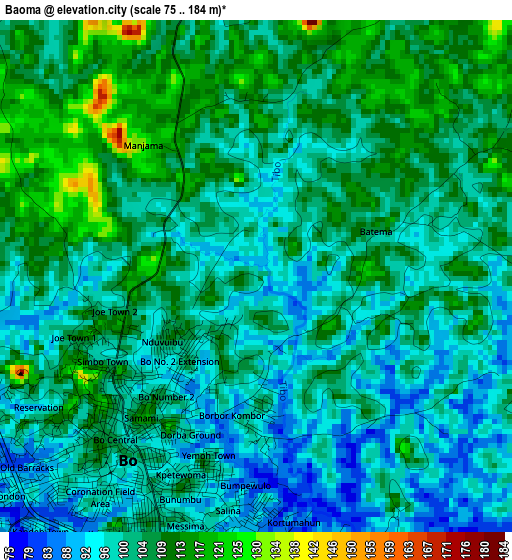
Below is the Elevation map of Baoma, which displays elevation range with different colors. Scale of the first map is from 75 to 184 m (246 to 604 ft) with average elevation of 102.9 meters (=338 ft) [note 1]
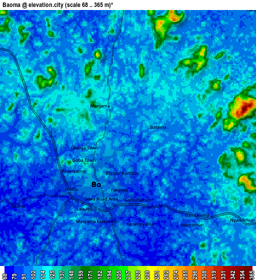
These maps also provides idea of topography and contour of this city, they are displayed at different zoom levels. More info about maps, scale and edge coordinates you can find below images.
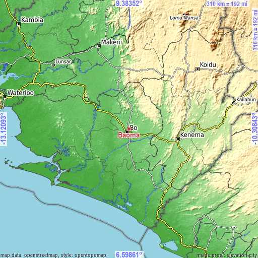
| \ | Map #1 | Map #2 | Topo.Map |
| Scale [m] | 75..184 m | 68..365 m | × |
| Scale [ft] | 246..604 ft | 223..1198 ft | × |
| Average | 102.9 m = 338 ft | 106.5 m = 349 ft | × |
| Width | 9.68 km = 6 mi | 19.36 km = 12 mi | 309.7 km = 192.4 mi |
| Height | 9.68 km = 6 mi | 19.36 km = 12 mi | 309.7 km = 192.4 mi |
| ↑Max Latitude | 8.036956° | 8.080467° | 9.38352° |
| Latitude at center | 7.99344° | 7.99344° | 7.99344° |
| ↓Min Latitude | 7.949919° | 7.906394° | 6.59861° |
| ← Min Longitude | -11.758625° | -11.802571° | -13.12093° |
| Longitude center | -11.71468° | -11.71468° | -11.71468° |
| →Max Longitude | -11.670735° | -11.626789° | -10.30843° |
Nearby cities:
Cities around Baoma sort by population:
• Bo elevation 104 m
4.1 km,  219°
219°
• Bumpe 38 m
23.8 km,  241°
241°
• Gandorhun 58 m
48.8 km,  177°
177°
• Blama 122 m
42.7 km,  107°
107°
• Boajibu 150 m
46.5 km,  62°
62°
• Sumbuya 39 m
47 km, 215°
• Mamboma 105 m
10.8 km,  15°
15°
• Koribundu 79 m
31.7 km, 175°
• Serabu 44 m
43.4 km, 239°
• Gbewebu 79 m
50.6 km,  166°
166°
• Palima 253 m
26.8 km, 58°
• Baiima 69 m
19.4 km,  311°
311°
Multilingual:
 En español:
Baoma elevación 100 m.
 En France:
Baoma élévation 100 m.


Sources and notes:
- [note 1] Map square and city borders are not equal. Map elevation data is calculated only from area inside that square.
- [src 1] Elevation data from geonames database provided with same terms of usage.
- [src 2] The elevation map of Baoma is generated using elevation data from NASA's 3 arcsec (90m) resolution SRTM data.
- [src 3] Base (background) map © OpenStreetMap contributors tiles are generated by Geofabrik and OpenTopoMap.
Copyright & License:
This Baoma Elevation Map is licensed under CC BY-SA. You may reuse any part from this page, if you give a proper credit by linking to this URL:
 More info on terms of use page.