Banská Bystrica elevation
Banská Bystrica (Banskobystrický kraj, Okres Banská Bystrica), Slovakia elevation is 351 meters and Banská Bystrica elevation in feet is 1152 ft above sea level [src 1]. Banská Bystrica is a seat of a first-order administrative division (feature code) with elevation that is 31 meters (102 ft) bigger than average city elevation in Slovakia.
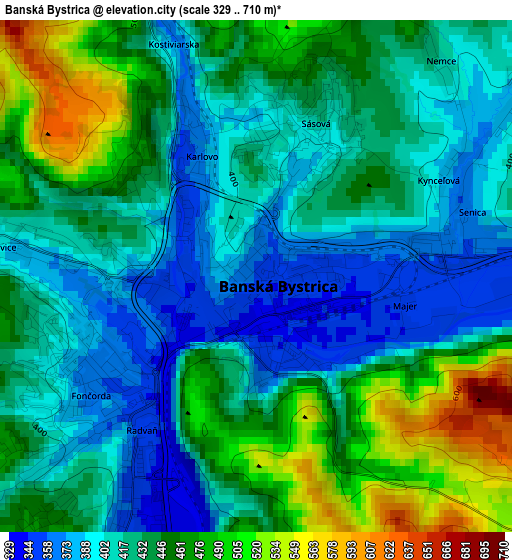
Below is the Elevation map of Banská Bystrica, which displays elevation range with different colors. Scale of the first map is from 329 to 710 m (1079 to 2329 ft) with average elevation of 433.8 meters (=1423 ft) [note 1]
These maps also provides idea of topography and contour of this city, they are displayed at different zoom levels. More info about maps, scale and edge coordinates you can find below images.
| \ | Map #1 | Map #2 | Topo.Map |
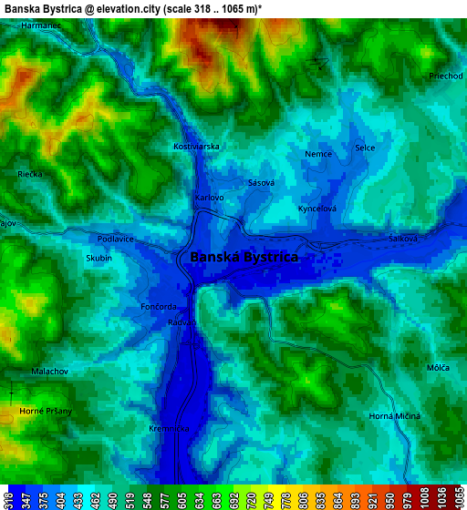
| Scale [m] | 329..710 m | 318..1065 m | × |
| Scale [ft] | 1079..2329 ft | 1043..3494 ft | × |
| Average | 433.8 m = 1423 ft | 509.6 m = 1672 ft | × |
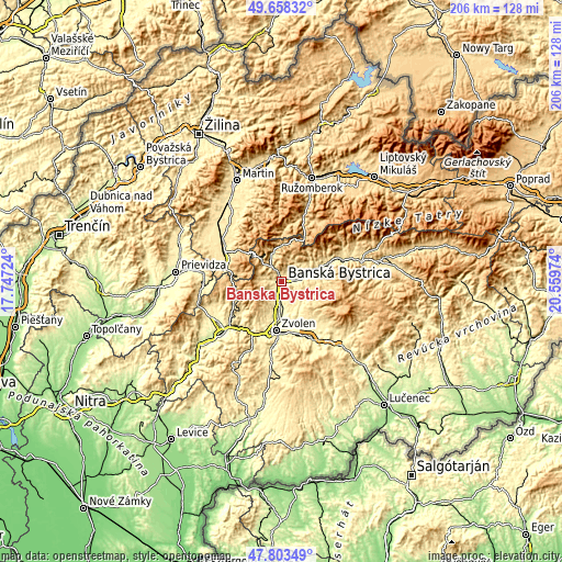
| Width | 6.44 km = 4 mi | 12.89 km = 8 mi | 206.2 km = 128.1 mi |
| Height | 6.44 km = 4 mi | 12.89 km = 8 mi | 206.2 km = 128.1 mi |
| ↑Max Latitude | 48.768433° | 48.797389° | 49.65832° |
| Latitude at center | 48.73946° | 48.73946° | 48.73946° |
| ↓Min Latitude | 48.71047° | 48.681464° | 47.80349° |
| ← Min Longitude | 19.109545° | 19.065599° | 17.74724° |
| Longitude center | 19.15349° | 19.15349° | 19.15349° |
| →Max Longitude | 19.197435° | 19.241381° | 20.55974° |
Nearby cities:
Cities around Banská Bystrica sort by population:
• Zvolen elevation 297 m
18.4 km,  180°
180°
• Brezno 492 m
36.1 km,  78°
78°
• Žiar nad Hronom 279 m
27.7 km,  233°
233°
• Handlová 424 m
28.9 km,  267°
267°
• Detva 414 m
27.9 km,  135°
135°
• Banská Štiavnica 522 m
37 km,  208°
208°
• Hriňová 476 m
32.7 km,  123°
123°
• Kremnica 566 m
17.7 km,  257°
257°
• Čierny Balog 530 m
36.5 km,  88°
88°
• Kováčová 310 m
15.8 km,  193°
193°
• Hrochoť,Slovakia 619 m
15 km,  128°
128°
• Turčianske Teplice 509 m
25.4 km,  302°
302°
Multilingual:
 En español:
Banská Bystrica elevación 351 m.
 En France:
Banská Bystrica élévation 351 m.


Sources and notes:
- [note 1] Map square and city borders are not equal. Map elevation data is calculated only from area inside that square.
- [src 1] Elevation data from geonames database provided with same terms of usage.
- [src 2] The elevation map of Banská Bystrica is generated using elevation data from NASA's 3 arcsec (90m) resolution SRTM data.
- [src 3] Base (background) map © OpenStreetMap contributors tiles are generated by Geofabrik and OpenTopoMap.
Copyright & License:
This Banská Bystrica Elevation Map is licensed under CC BY-SA. You may reuse any part from this page, if you give a proper credit by linking to this URL:
 More info on terms of use page.