Fiľakovo elevation
Fiľakovo (Banskobystrický kraj, Okres Lučenec), Slovakia elevation is 191 meters and Fiľakovo elevation in feet is 627 ft above sea level [src 1]. Fiľakovo is a seat of a third-order administrative division (feature code) with elevation that is 129 meters (423 ft) smaller than average city elevation in Slovakia.
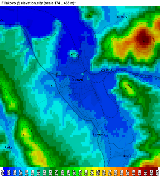
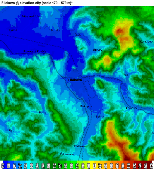
Below is the Elevation map of Fiľakovo, which displays elevation range with different colors. Scale of the first map is from 174 to 463 m (571 to 1519 ft) with average elevation of 236.8 meters (=777 ft) [note 1]
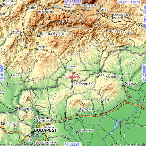
These maps also provides idea of topography and contour of this city, they are displayed at different zoom levels. More info about maps, scale and edge coordinates you can find below images.
| \ | Map #1 | Map #2 | Topo.Map |
| Scale [m] | 174..463 m | 170..579 m | × |
| Scale [ft] | 571..1519 ft | 558..1900 ft | × |
| Average | 236.8 m = 777 ft | 260.7 m = 855 ft | × |
| Width | 6.51 km = 4 mi | 13.01 km = 8.1 mi | 208.2 km = 129.4 mi |
| Height | 6.51 km = 4 mi | 13.01 km = 8.1 mi | 208.2 km = 129.4 mi |
| ↑Max Latitude | 48.296814° | 48.326041° | 49.19508° |
| Latitude at center | 48.26757° | 48.26757° | 48.26757° |
| ↓Min Latitude | 48.238309° | 48.209032° | 47.32291° |
| ← Min Longitude | 19.780785° | 19.736839° | 18.41848° |
| Longitude center | 19.82473° | 19.82473° | 19.82473° |
| →Max Longitude | 19.868675° | 19.912621° | 21.23098° |
Nearby cities:
Cities around Fiľakovo sort by population:
• Zvolen elevation 297 m
60.2 km,  304°
304°
• Lučenec 187 m
13.7 km, 301°
• Rimavská Sobota 208 m
19.4 km,  48°
48°
• Detva 414 m
44.2 km,  317°
317°
• Revúca 318 m
51 km,  25°
25°
• Veľký Krtíš 218 m
35.7 km,  259°
259°
• Hriňová 476 m
41 km,  327°
327°
• Krupina 270 m
57 km,  279°
279°
• Poltár 246 m
18.3 km,  352°
352°
• Čierny Balog 530 m
54.8 km, 346°
• Tisovec 400 m
46.4 km,  10°
10°
• Hrochoť,Slovakia 619 m
57.3 km, 318°
Multilingual:
 En español:
Fiľakovo elevación 191 m.
 En France:
Fiľakovo élévation 191 m.
 Auf Deutsch:
Fiľakovo höhe über dem Meeresspiegel ist 191 m.

Sources and notes:
- [note 1] Map square and city borders are not equal. Map elevation data is calculated only from area inside that square.
- [src 1] Elevation data from geonames database provided with same terms of usage.
- [src 2] The elevation map of Fiľakovo is generated using elevation data from NASA's 3 arcsec (90m) resolution SRTM data.
- [src 3] Base (background) map © OpenStreetMap contributors tiles are generated by Geofabrik and OpenTopoMap.
Copyright & License:
This Fiľakovo Elevation Map is licensed under CC BY-SA. You may reuse any part from this page, if you give a proper credit by linking to this URL:
 More info on terms of use page.