Galanta elevation
Galanta (Trnavský kraj, Okres Galanta), Slovakia elevation is 119 meters and Galanta elevation in feet is 390 ft above sea level [src 1]. Galanta is a populated place (feature code) with elevation that is 201 meters (659 ft) smaller than average city elevation in Slovakia.
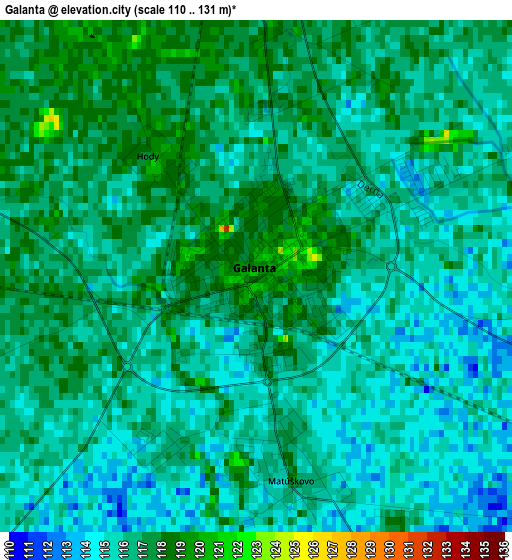
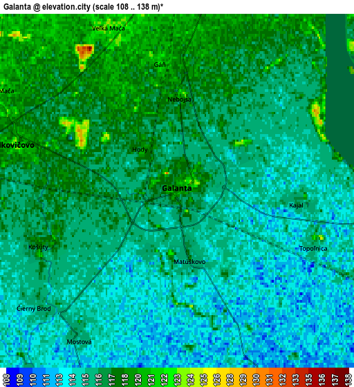
Below is the Elevation map of Galanta, which displays elevation range with different colors. Scale of the first map is from 110 to 131 m (361 to 430 ft) with average elevation of 116 meters (=381 ft) [note 1]
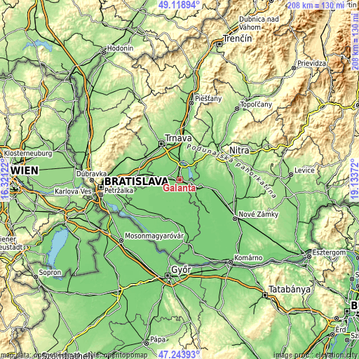
These maps also provides idea of topography and contour of this city, they are displayed at different zoom levels. More info about maps, scale and edge coordinates you can find below images.
| \ | Map #1 | Map #2 | Topo.Map |
| Scale [m] | 110..131 m | 108..138 m | × |
| Scale [ft] | 361..430 ft | 354..453 ft | × |
| Average | 116 m = 381 ft | 115.9 m = 380 ft | × |
| Width | 6.51 km = 4 mi | 13.03 km = 8.1 mi | 208.5 km = 129.6 mi |
| Height | 6.51 km = 4 mi | 13.03 km = 8.1 mi | 208.5 km = 129.6 mi |
| ↑Max Latitude | 48.219298° | 48.24857° | 49.11894° |
| Latitude at center | 48.19001° | 48.19001° | 48.19001° |
| ↓Min Latitude | 48.160705° | 48.131383° | 47.24393° |
| ← Min Longitude | 17.683525° | 17.639579° | 16.32122° |
| Longitude center | 17.72747° | 17.72747° | 17.72747° |
| →Max Longitude | 17.771415° | 17.815361° | 19.13372° |
Nearby cities:
Cities around Galanta sort by population:
• Nitra elevation 144 m
29.5 km,  63°
63°
• Trnava 147 m
23.3 km,  333°
333°
• Šaľa 114 m
12.1 km,  110°
110°
• Hlohovec 144 m
27.5 km,  11°
11°
• Dunajská Streda 117 m
23.6 km,  201°
201°
• Senec 127 m
24.5 km,  277°
277°
• Modra 173 m
35 km,  297°
297°
• Ivanka pri Dunaji 132 m
35 km,  269°
269°
• Sládkovičovo 118 m
6.7 km, 280°
• Gabčíkovo 116 m
34.9 km, 198°
• Leopoldov 143 m
28.6 km, 5°
• Vinosady 145 m
35.1 km,  292°
292°
Multilingual:
 En español:
Galanta elevación 119 m.
 En France:
Galánta élévation 119 m.


Sources and notes:
- [note 1] Map square and city borders are not equal. Map elevation data is calculated only from area inside that square.
- [src 1] Elevation data from geonames database provided with same terms of usage.
- [src 2] The elevation map of Galanta is generated using elevation data from NASA's 3 arcsec (90m) resolution SRTM data.
- [src 3] Base (background) map © OpenStreetMap contributors tiles are generated by Geofabrik and OpenTopoMap.
Copyright & License:
This Galanta Elevation Map is licensed under CC BY-SA. You may reuse any part from this page, if you give a proper credit by linking to this URL:
 More info on terms of use page.