Štúrovo elevation
Štúrovo (Nitriansky kraj, Okres Nové Zámky), Slovakia elevation is 110 meters and Štúrovo elevation in feet is 361 ft above sea level [src 1]. Štúrovo is a populated place (feature code) with elevation that is 210 meters (689 ft) smaller than average city elevation in Slovakia.
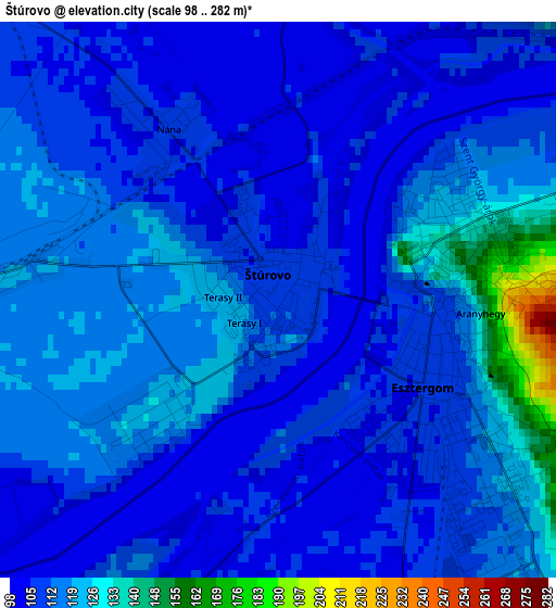
Below is the Elevation map of Štúrovo, which displays elevation range with different colors. Scale of the first map is from 98 to 282 m (322 to 925 ft) with average elevation of 113.7 meters (=373 ft) [note 1]
These maps also provides idea of topography and contour of this city, they are displayed at different zoom levels. More info about maps, scale and edge coordinates you can find below images.
| \ | Map #1 | Map #2 | Topo.Map |
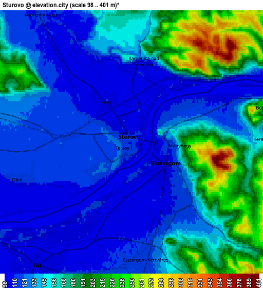
| Scale [m] | 98..282 m | 98..401 m | × |
| Scale [ft] | 322..925 ft | 322..1316 ft | × |
| Average | 113.7 m = 373 ft | 147.2 m = 483 ft | × |
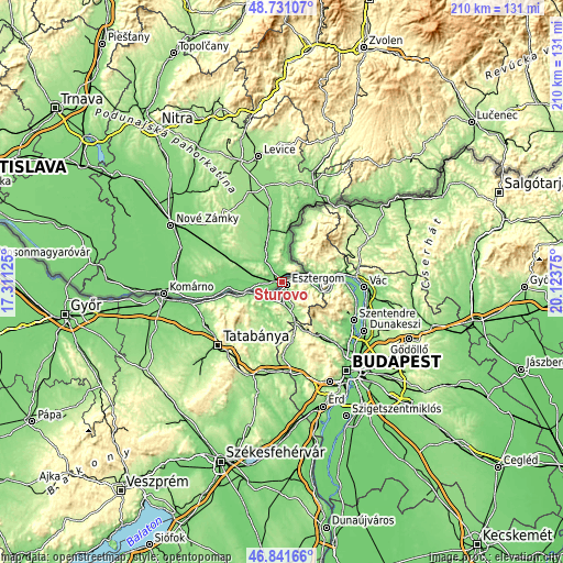
| Width | 6.56 km = 4.1 mi | 13.13 km = 8.2 mi | 210.1 km = 130.5 mi |
| Height | 6.56 km = 4.1 mi | 13.13 km = 8.2 mi | 210.1 km = 130.5 mi |
| ↑Max Latitude | 47.824463° | 47.85396° | 48.73107° |
| Latitude at center | 47.79495° | 47.79495° | 47.79495° |
| ↓Min Latitude | 47.76542° | 47.735873° | 46.84166° |
| ← Min Longitude | 18.673555° | 18.629609° | 17.31125° |
| Longitude center | 18.7175° | 18.7175° | 18.7175° |
| →Max Longitude | 18.761445° | 18.805391° | 20.12375° |
Nearby cities:
Cities around Štúrovo sort by population:
• Nové Zámky elevation 122 m
46.5 km,  297°
297°
• Levice 162 m
47.5 km,  350°
350°
• Komárno 116 m
44.6 km,  265°
265°
• Kolárovo 109 m
56.5 km,  284°
284°
• Šurany 122 m
51.2 km,  309°
309°
• Hurbanovo 111 m
40.1 km, 281°
• Šahy 143 m
35.5 km,  29°
29°
• Želiezovce 135 m
28.8 km, 350°
• Tlmače 174 m
56.7 km, 345°
• Svodín 202 m
20.7 km, 308°
• Dudince 138 m
43.7 km,  16°
16°
• Komárno 160 m
46.6 km,  320°
320°
Multilingual:
 En español:
Štúrovo elevación 110 m.
 En France:
Štúrovo élévation 110 m.


Sources and notes:
- [note 1] Map square and city borders are not equal. Map elevation data is calculated only from area inside that square.
- [src 1] Elevation data from geonames database provided with same terms of usage.
- [src 2] The elevation map of Štúrovo is generated using elevation data from NASA's 3 arcsec (90m) resolution SRTM data.
- [src 3] Base (background) map © OpenStreetMap contributors tiles are generated by Geofabrik and OpenTopoMap.
Copyright & License:
This Štúrovo Elevation Map is licensed under CC BY-SA. You may reuse any part from this page, if you give a proper credit by linking to this URL:
 More info on terms of use page.