Zreče elevation
Zreče, Slovenia elevation is 423 meters and Zreče elevation in feet is 1388 ft above sea level [src 1]. Zreče is a seat of a first-order administrative division (feature code) with elevation that is 109 meters (358 ft) bigger than average city elevation in Slovenia.
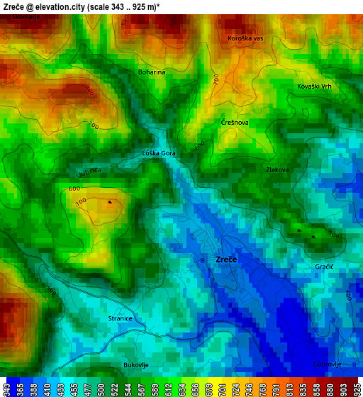
Below is the Elevation map of Zreče, which displays elevation range with different colors. Scale of the first map is from 343 to 925 m (1125 to 3035 ft) with average elevation of 559.5 meters (=1836 ft) [note 1]
These maps also provides idea of topography and contour of this city, they are displayed at different zoom levels. More info about maps, scale and edge coordinates you can find below images.
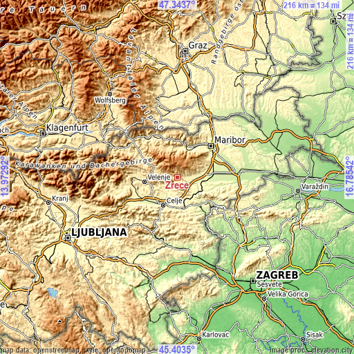
| \ | Map #1 | Topo.Map |
| Scale [m] | 343..925 m | × |
| Scale [ft] | 1125..3035 ft | × |
| Average | 559.5 m = 1836 ft | × |
| Width | 6.74 km = 4.2 mi | 215.7 km = 134 mi |
| Height | 6.74 km = 4.2 mi | 215.7 km = 134 mi |
| ↑Max Latitude | 46.412527° | 47.3437° |
| Latitude at center | 46.38222° | 46.38222° |
| ↓Min Latitude | 46.351896° | 45.4035° |
| ← Min Longitude | 15.335225° | 13.97292° |
| Longitude center | 15.37917° | 15.37917° |
| →Max Longitude | 15.423115° | 16.78542° |
Nearby cities:
Cities around Zreče sort by population:
• Slovenska Bistrica elevation 274 m
15 km,  85°
85°
• Slovenske Konjice 320 m
6.2 km,  144°
144°
• Šentjur 301 m
18.4 km,  175°
175°
• Vojnik 274 m
11.5 km,  210°
210°
• Lovrenc na Pohorju 421 m
17.6 km,  3°
3°
• Mislinja 617 m
15.2 km,  295°
295°
• Oplotnica 377 m
5.2 km,  83°
83°
• Trnovlje pri Celju 246 m
15.4 km,  204°
204°
• Poljčane 260 m
17.2 km,  116°
116°
• Ljubečna 259 m
14.7 km, 196°
• Vitanje 453 m
6.4 km,  269°
269°
• Dobrna 381 m
12.7 km,  247°
247°
Multilingual:
 En español:
Zreče elevación 423 m.
 En France:
Zreče élévation 423 m.


Sources and notes:
- [note 1] Map square and city borders are not equal. Map elevation data is calculated only from area inside that square.
- [src 1] Elevation data from geonames database provided with same terms of usage.
- [src 2] The elevation map of Zreče is generated using elevation data from NASA's 3 arcsec (90m) resolution SRTM data.
- [src 3] Base (background) map © OpenStreetMap contributors tiles are generated by Geofabrik and OpenTopoMap.
Copyright & License:
This Zreče Elevation Map is licensed under CC BY-SA. You may reuse any part from this page, if you give a proper credit by linking to this URL:
 More info on terms of use page.