Oplotnica elevation
Oplotnica, Slovenia elevation is 377 meters and Oplotnica elevation in feet is 1237 ft above sea level [src 1]. Oplotnica is a seat of a first-order administrative division (feature code) with elevation that is 63 meters (207 ft) bigger than average city elevation in Slovenia.
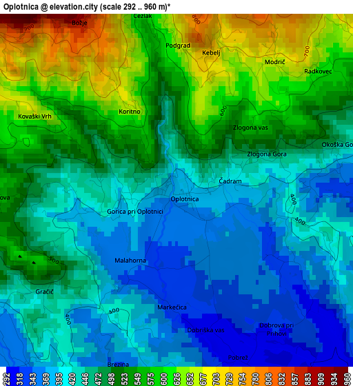
Below is the Elevation map of Oplotnica, which displays elevation range with different colors. Scale of the first map is from 292 to 960 m (958 to 3150 ft) with average elevation of 484.7 meters (=1590 ft) [note 1]
These maps also provides idea of topography and contour of this city, they are displayed at different zoom levels. More info about maps, scale and edge coordinates you can find below images.
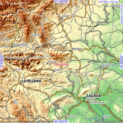
| \ | Map #1 | Topo.Map |
| Scale [m] | 292..960 m | × |
| Scale [ft] | 958..3150 ft | × |
| Average | 484.7 m = 1590 ft | × |
| Width | 6.74 km = 4.2 mi | 215.7 km = 134 mi |
| Height | 6.74 km = 4.2 mi | 215.7 km = 134 mi |
| ↑Max Latitude | 46.418084° | 47.34916° |
| Latitude at center | 46.38778° | 46.38778° |
| ↓Min Latitude | 46.357459° | 45.40916° |
| ← Min Longitude | 15.402725° | 14.04042° |
| Longitude center | 15.44667° | 15.44667° |
| →Max Longitude | 15.490615° | 16.85292° |
Nearby cities:
Cities around Oplotnica sort by population:
• Slovenska Bistrica elevation 274 m
9.8 km,  86°
86°
• Slovenske Konjice 320 m
5.9 km,  195°
195°
• Zreče 423 m
5.2 km,  263°
263°
• Vojnik 274 m
15.2 km,  226°
226°
• Lovrenc na Pohorju 421 m
17.5 km,  346°
346°
• Zgornja Polskava 294 m
13.4 km,  71°
71°
• Poljčane 260 m
13.2 km,  129°
129°
• Pragersko 250 m
16.4 km, 86°
• Ljubečna 259 m
17.4 km,  212°
212°
• Morje 310 m
14.8 km,  64°
64°
• Fram 322 m
16 km, 61°
• Vitanje 453 m
11.6 km,  266°
266°
Multilingual:
 En español:
Oplotnica elevación 377 m.
 En France:
Oplotnica élévation 377 m.
 Auf Deutsch:
Oplotnica höhe über dem Meeresspiegel ist 377 m.

Sources and notes:
- [note 1] Map square and city borders are not equal. Map elevation data is calculated only from area inside that square.
- [src 1] Elevation data from geonames database provided with same terms of usage.
- [src 2] The elevation map of Oplotnica is generated using elevation data from NASA's 3 arcsec (90m) resolution SRTM data.
- [src 3] Base (background) map © OpenStreetMap contributors tiles are generated by Geofabrik and OpenTopoMap.
Copyright & License:
This Oplotnica Elevation Map is licensed under CC BY-SA. You may reuse any part from this page, if you give a proper credit by linking to this URL:
 More info on terms of use page.