Logatec elevation
Logatec, Slovenia elevation is 473 meters and Logatec elevation in feet is 1552 ft above sea level [src 1]. Logatec is a seat of a first-order administrative division (feature code) with elevation that is 159 meters (522 ft) bigger than average city elevation in Slovenia.
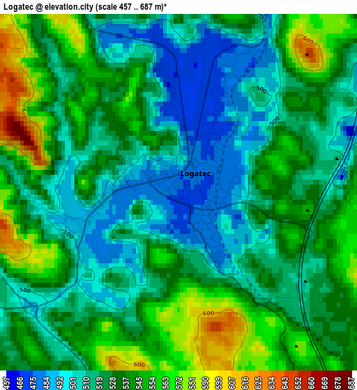
Below is the Elevation map of Logatec, which displays elevation range with different colors. Scale of the first map is from 457 to 687 m (1499 to 2254 ft) with average elevation of 527.6 meters (=1731 ft) [note 1]
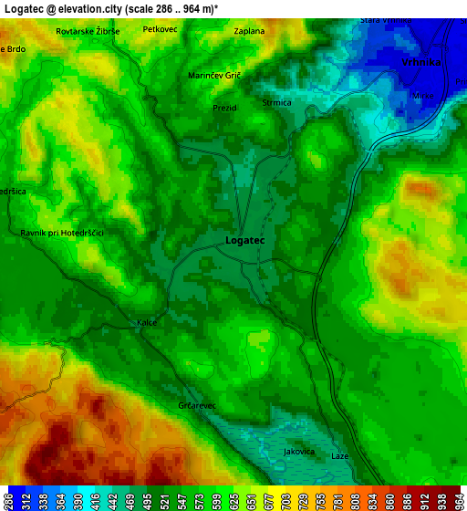
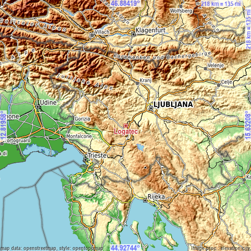
These maps also provides idea of topography and contour of this city, they are displayed at different zoom levels. More info about maps, scale and edge coordinates you can find below images.
| \ | Map #1 | Map #2 | Topo.Map |
| Scale [m] | 457..687 m | 286..964 m | × |
| Scale [ft] | 1499..2254 ft | 938..3163 ft | × |
| Average | 527.6 m = 1731 ft | 573.8 m = 1883 ft | × |
| Width | 6.8 km = 4.2 mi | 13.6 km = 8.5 mi | 217.6 km = 135.2 mi |
| Height | 6.8 km = 4.2 mi | 13.6 km = 8.5 mi | 217.6 km = 135.2 mi |
| ↑Max Latitude | 45.945006° | 45.975555° | 46.88419° |
| Latitude at center | 45.91444° | 45.91444° | 45.91444° |
| ↓Min Latitude | 45.883857° | 45.853258° | 44.92744° |
| ← Min Longitude | 14.181885° | 14.137939° | 12.81958° |
| Longitude center | 14.22583° | 14.22583° | 14.22583° |
| →Max Longitude | 14.269775° | 14.313721° | 15.63208° |
Nearby cities:
Cities around Logatec sort by population:
• Postojna elevation 548 m
15.6 km,  183°
183°
• Vrhnika 297 m
7.6 km,  44°
44°
• Idrija 341 m
18 km,  303°
303°
• Cerknica 565 m
17.2 km,  141°
141°
• Žiri 479 m
16.9 km,  327°
327°
• Borovnica 335 m
10.6 km,  89°
89°
• Rakek 526 m
13 km,  149°
149°
• Verd 293 m
7.8 km,  52°
52°
• Notranje Gorice 302 m
15.7 km,  58°
58°
• Log pri Brezovici 444 m
15.7 km, 43°
• Dragomer 292 m
16.7 km, 46°
• Horjul 348 m
13.4 km,  25°
25°
Multilingual:
 En español:
Logatec elevación 473 m.
 En France:
Logatec élévation 473 m.


Sources and notes:
- [note 1] Map square and city borders are not equal. Map elevation data is calculated only from area inside that square.
- [src 1] Elevation data from geonames database provided with same terms of usage.
- [src 2] The elevation map of Logatec is generated using elevation data from NASA's 3 arcsec (90m) resolution SRTM data.
- [src 3] Base (background) map © OpenStreetMap contributors tiles are generated by Geofabrik and OpenTopoMap.
Copyright & License:
This Logatec Elevation Map is licensed under CC BY-SA. You may reuse any part from this page, if you give a proper credit by linking to this URL:
 More info on terms of use page.