Ajdovščina elevation
Ajdovščina, Slovenia elevation is 103 meters and Ajdovščina elevation in feet is 338 ft above sea level [src 1]. Ajdovščina is a seat of a first-order administrative division (feature code) with elevation that is 211 meters (692 ft) smaller than average city elevation in Slovenia.
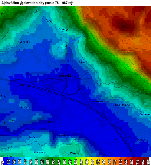
Below is the Elevation map of Ajdovščina, which displays elevation range with different colors. Scale of the first map is from 78 to 987 m (256 to 3238 ft) with average elevation of 276.2 meters (=906 ft) [note 1]
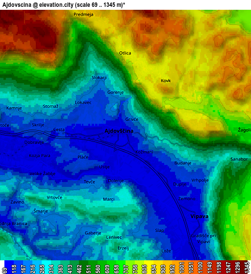
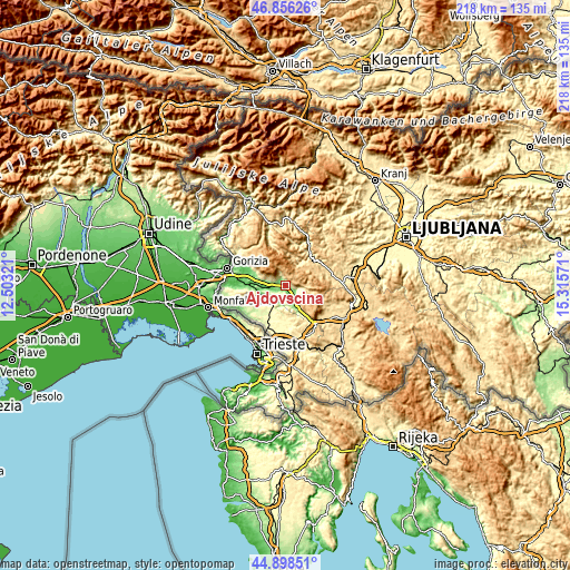
These maps also provides idea of topography and contour of this city, they are displayed at different zoom levels. More info about maps, scale and edge coordinates you can find below images.
| \ | Map #1 | Map #2 | Topo.Map |
| Scale [m] | 78..987 m | 69..1345 m | × |
| Scale [ft] | 256..3238 ft | 226..4413 ft | × |
| Average | 276.2 m = 906 ft | 471.2 m = 1546 ft | × |
| Width | 6.8 km = 4.2 mi | 13.61 km = 8.5 mi | 217.7 km = 135.3 mi |
| Height | 6.8 km = 4.2 mi | 13.61 km = 8.5 mi | 217.7 km = 135.3 mi |
| ↑Max Latitude | 45.916591° | 45.947156° | 46.85626° |
| Latitude at center | 45.88601° | 45.88601° | 45.88601° |
| ↓Min Latitude | 45.855412° | 45.824797° | 44.89851° |
| ← Min Longitude | 13.865515° | 13.821569° | 12.50321° |
| Longitude center | 13.90946° | 13.90946° | 13.90946° |
| →Max Longitude | 13.953405° | 13.997351° | 15.31571° |
Nearby cities:
Cities around Ajdovščina sort by population:
• Idrija elevation 341 m
16 km,  35°
35°
• Sežana 370 m
19.9 km,  188°
188°
• Kromberk 135 m
20.6 km,  293°
293°
• Renče 53 m
18.6 km,  271°
271°
• Vipava 110 m
6 km,  136°
136°
• Spodnja Idrija 310 m
18.6 km,  29°
29°
• Prvačina 73 m
14.8 km, 271°
• Šempas 93 m
13.7 km, 290°
• Rožna Dolina 144 m
19.7 km, 288°
• Lokavec 167 m
2.9 km,  307°
307°
• Volčja Draga 74 m
18.1 km,  277°
277°
• Komen 267 m
14.8 km,  237°
237°
Multilingual:
 En español:
Ajdovščina elevación 103 m.
 En France:
Ajdovščina élévation 103 m.
 Auf Deutsch:
Ajdovščina höhe über dem Meeresspiegel ist 103 m.

Sources and notes:
- [note 1] Map square and city borders are not equal. Map elevation data is calculated only from area inside that square.
- [src 1] Elevation data from geonames database provided with same terms of usage.
- [src 2] The elevation map of Ajdovščina is generated using elevation data from NASA's 3 arcsec (90m) resolution SRTM data.
- [src 3] Base (background) map © OpenStreetMap contributors tiles are generated by Geofabrik and OpenTopoMap.
Copyright & License:
This Ajdovščina Elevation Map is licensed under CC BY-SA. You may reuse any part from this page, if you give a proper credit by linking to this URL:
 More info on terms of use page.