Apače elevation
Apače, Slovenia elevation is 218 meters and Apače elevation in feet is 715 ft above sea level [src 1]. Apače is a seat of a first-order administrative division (feature code) with elevation that is 96 meters (315 ft) smaller than average city elevation in Slovenia.
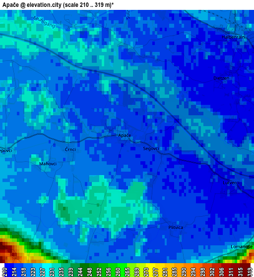
Below is the Elevation map of Apače, which displays elevation range with different colors. Scale of the first map is from 210 to 319 m (689 to 1047 ft) with average elevation of 221.3 meters (=726 ft) [note 1]
These maps also provides idea of topography and contour of this city, they are displayed at different zoom levels. More info about maps, scale and edge coordinates you can find below images.
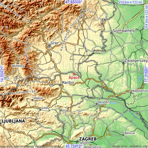
| \ | Map #1 | Topo.Map |
| Scale [m] | 210..319 m | × |
| Scale [ft] | 689..1047 ft | × |
| Average | 221.3 m = 726 ft | × |
| Width | 6.7 km = 4.2 mi | 214.5 km = 133.3 mi |
| Height | 6.7 km = 4.2 mi | 214.5 km = 133.3 mi |
| ↑Max Latitude | 46.727352° | 47.65309° |
| Latitude at center | 46.69722° | 46.69722° |
| ↓Min Latitude | 46.667072° | 45.72412° |
| ← Min Longitude | 15.866615° | 14.50431° |
| Longitude center | 15.91056° | 15.91056° |
| →Max Longitude | 15.954505° | 17.31681° |
Nearby cities:
Cities around Apače sort by population:
• Gornja Radgona elevation 214 m
6.8 km,  113°
113°
• Lenart v Slov. Goricah 261 m
14.8 km,  204°
204°
• Radenci 205 m
11.5 km,  122°
122°
• Selnica ob Muri 301 m
16.1 km,  264°
264°
• Benedikt 242 m
10 km,  189°
189°
• Sv. Trojica v Slov. Goricah 272 m
13.6 km, 190°
• Cankova 215 m
8.9 km,  72°
72°
• Tišina 192 m
14.5 km, 107°
• Jurovski Dol 265 m
13.9 km,  223°
223°
• Rogašovci 231 m
14.8 km,  39°
39°
• Sv. Ana v Slov. Goricah 349 m
7.4 km, 223°
• Cerkvenjak 318 m
14.3 km,  169°
169°
Multilingual:
 En español:
Apače elevación 218 m.
 En France:
Apače élévation 218 m.


Sources and notes:
- [note 1] Map square and city borders are not equal. Map elevation data is calculated only from area inside that square.
- [src 1] Elevation data from geonames database provided with same terms of usage.
- [src 2] The elevation map of Apače is generated using elevation data from NASA's 3 arcsec (90m) resolution SRTM data.
- [src 3] Base (background) map © OpenStreetMap contributors tiles are generated by Geofabrik and OpenTopoMap.
Copyright & License:
This Apače Elevation Map is licensed under CC BY-SA. You may reuse any part from this page, if you give a proper credit by linking to this URL:
 More info on terms of use page.