Cankova elevation
Cankova, Slovenia elevation is 215 meters and Cankova elevation in feet is 705 ft above sea level [src 1]. Cankova is a seat of a first-order administrative division (feature code) with elevation that is 99 meters (325 ft) smaller than average city elevation in Slovenia.
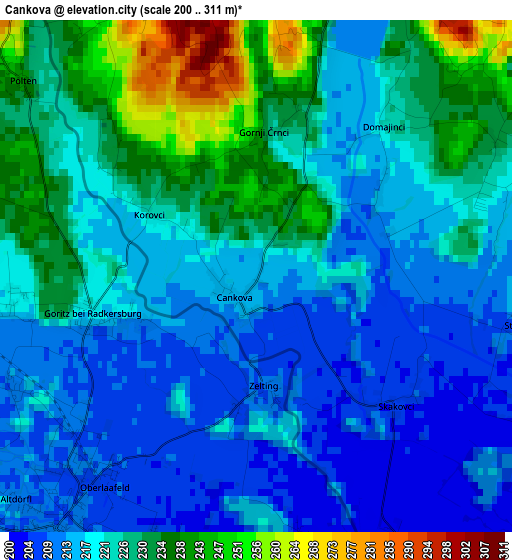
Below is the Elevation map of Cankova, which displays elevation range with different colors. Scale of the first map is from 200 to 311 m (656 to 1020 ft) with average elevation of 221.8 meters (=728 ft) [note 1]
These maps also provides idea of topography and contour of this city, they are displayed at different zoom levels. More info about maps, scale and edge coordinates you can find below images.
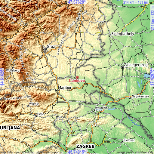
| \ | Map #1 | Topo.Map |
| Scale [m] | 200..311 m | × |
| Scale [ft] | 656..1020 ft | × |
| Average | 221.8 m = 728 ft | × |
| Width | 6.7 km = 4.2 mi | 214.4 km = 133.2 mi |
| Height | 6.7 km = 4.2 mi | 214.4 km = 133.2 mi |
| ↑Max Latitude | 46.750948° | 47.67628° |
| Latitude at center | 46.72083° | 46.72083° |
| ↓Min Latitude | 46.690695° | 45.74815° |
| ← Min Longitude | 15.978555° | 14.61625° |
| Longitude center | 16.0225° | 16.0225° |
| →Max Longitude | 16.066445° | 17.42875° |
Nearby cities:
Cities around Cankova sort by population:
• Murska Sobota elevation 192 m
12.7 km,  120°
120°
• Gornja Radgona 214 m
5.8 km,  203°
203°
• Radenci 205 m
8.8 km,  172°
172°
• Bakovci 185 m
15 km,  139°
139°
• Černelavci 192 m
10.4 km,  125°
125°
• Krog 188 m
12.9 km, 135°
• Grad 337 m
10.6 km,  33°
33°
• Puconci 205 m
10.3 km,  98°
98°
• Apače 218 m
8.9 km,  252°
252°
• Tišina 192 m
8.7 km, 142°
• Kuzma 260 m
13.7 km,  19°
19°
• Rogašovci 231 m
8.8 km,  5°
5°
Multilingual:
 En español:
Cankova elevación 215 m.
 En France:
Cankova élévation 215 m.


Sources and notes:
- [note 1] Map square and city borders are not equal. Map elevation data is calculated only from area inside that square.
- [src 1] Elevation data from geonames database provided with same terms of usage.
- [src 2] The elevation map of Cankova is generated using elevation data from NASA's 3 arcsec (90m) resolution SRTM data.
- [src 3] Base (background) map © OpenStreetMap contributors tiles are generated by Geofabrik and OpenTopoMap.
Copyright & License:
This Cankova Elevation Map is licensed under CC BY-SA. You may reuse any part from this page, if you give a proper credit by linking to this URL:
 More info on terms of use page.