Ormož elevation
Ormož, Slovenia elevation is 225 meters and Ormož elevation in feet is 738 ft above sea level [src 1]. Ormož is a seat of a first-order administrative division (feature code) with elevation that is 89 meters (292 ft) smaller than average city elevation in Slovenia.
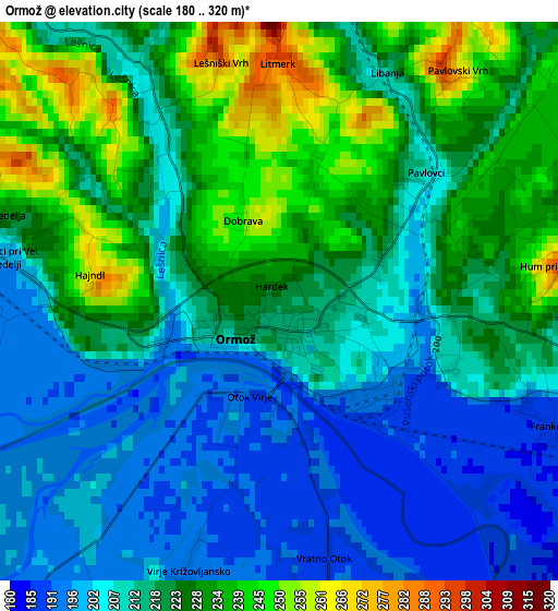
Below is the Elevation map of Ormož, which displays elevation range with different colors. Scale of the first map is from 180 to 320 m (591 to 1050 ft) with average elevation of 217.4 meters (=713 ft) [note 1]
These maps also provides idea of topography and contour of this city, they are displayed at different zoom levels. More info about maps, scale and edge coordinates you can find below images.
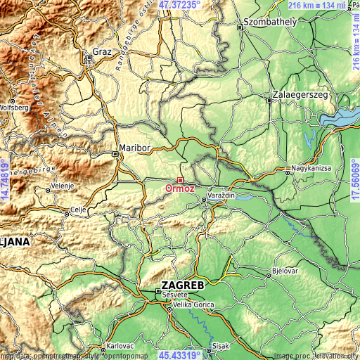
| \ | Map #1 | Topo.Map |
| Scale [m] | 180..320 m | × |
| Scale [ft] | 591..1050 ft | × |
| Average | 217.4 m = 713 ft | × |
| Width | 6.74 km = 4.2 mi | 215.6 km = 134 mi |
| Height | 6.74 km = 4.2 mi | 215.6 km = 134 mi |
| ↑Max Latitude | 46.441681° | 47.37235° |
| Latitude at center | 46.41139° | 46.41139° |
| ↓Min Latitude | 46.381082° | 45.43319° |
| ← Min Longitude | 16.110495° | 14.74819° |
| Longitude center | 16.15444° | 16.15444° |
| →Max Longitude | 16.198385° | 17.56069° |
Nearby cities:
Cities around Ormož sort by population:
• Ljutomer elevation 179 m
12.6 km,  15°
15°
• Dornava 217 m
15.6 km,  280°
280°
• Središče ob Dravi 182 m
8.9 km,  102°
102°
• Veržej 182 m
19.2 km,  2°
2°
• Gorišnica 210 m
10.8 km,  271°
271°
• Križevci pri Ljutomeru 185 m
17.5 km,  356°
356°
• Markovci 222 m
17.4 km,  264°
264°
• Cirkulane 240 m
14.4 km,  238°
238°
• Juršinci 235 m
16.2 km,  300°
300°
• Sveti Tomaž 274 m
9.7 km,  326°
326°
• Razkrižje 173 m
15.6 km,  38°
38°
• Zavrč 202 m
8.3 km,  254°
254°
Multilingual:
 En español:
Ormož elevación 225 m.
 En France:
Ormož élévation 225 m.


Sources and notes:
- [note 1] Map square and city borders are not equal. Map elevation data is calculated only from area inside that square.
- [src 1] Elevation data from geonames database provided with same terms of usage.
- [src 2] The elevation map of Ormož is generated using elevation data from NASA's 3 arcsec (90m) resolution SRTM data.
- [src 3] Base (background) map © OpenStreetMap contributors tiles are generated by Geofabrik and OpenTopoMap.
Copyright & License:
This Ormož Elevation Map is licensed under CC BY-SA. You may reuse any part from this page, if you give a proper credit by linking to this URL:
 More info on terms of use page.