Sveti Tomaž elevation
Sveti Tomaž, Slovenia elevation is 274 meters and Sveti Tomaž elevation in feet is 899 ft above sea level [src 1]. Sveti Tomaž is a seat of a first-order administrative division (feature code) with elevation that is 40 meters (131 ft) smaller than average city elevation in Slovenia.
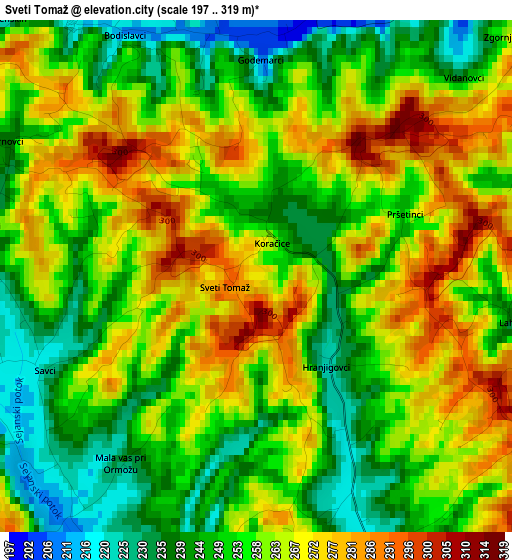
Below is the Elevation map of Sveti Tomaž, which displays elevation range with different colors. Scale of the first map is from 197 to 319 m (646 to 1047 ft) with average elevation of 258.1 meters (=847 ft) [note 1]
These maps also provides idea of topography and contour of this city, they are displayed at different zoom levels. More info about maps, scale and edge coordinates you can find below images.
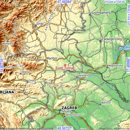
| \ | Map #1 | Topo.Map |
| Scale [m] | 197..319 m | × |
| Scale [ft] | 646..1047 ft | × |
| Average | 258.1 m = 847 ft | × |
| Width | 6.73 km = 4.2 mi | 215.3 km = 133.8 mi |
| Height | 6.73 km = 4.2 mi | 215.3 km = 133.8 mi |
| ↑Max Latitude | 46.51442° | 47.44384° |
| Latitude at center | 46.48417° | 46.48417° |
| ↓Min Latitude | 46.453903° | 45.50727° |
| ← Min Longitude | 16.039665° | 14.67736° |
| Longitude center | 16.08361° | 16.08361° |
| →Max Longitude | 16.127555° | 17.48986° |
Nearby cities:
Cities around Sveti Tomaž sort by population:
• Ljutomer elevation 179 m
9.6 km,  64°
64°
• Ormož 225 m
9.7 km,  146°
146°
• Dornava 217 m
11.3 km,  242°
242°
• Veržej 182 m
12.7 km,  29°
29°
• Gorišnica 210 m
9.4 km,  214°
214°
• Križevci pri Ljutomeru 185 m
10.3 km,  24°
24°
• Markovci 222 m
15.4 km,  230°
230°
• Vitomarci 254 m
12 km,  293°
293°
• Juršinci 235 m
8.6 km,  270°
270°
• Sveti Jurij ob Ščavnici 218 m
10.5 km,  334°
334°
• Cerkvenjak 318 m
14.4 km,  311°
311°
• Zavrč 202 m
10.6 km,  194°
194°
Multilingual:
 En español:
Sveti Tomaž elevación 274 m.
 En France:
Sveti Tomaž élévation 274 m.
 Auf Deutsch:
Sveti Tomaž höhe über dem Meeresspiegel ist 274 m.

Sources and notes:
- [note 1] Map square and city borders are not equal. Map elevation data is calculated only from area inside that square.
- [src 1] Elevation data from geonames database provided with same terms of usage.
- [src 2] The elevation map of Sveti Tomaž is generated using elevation data from NASA's 3 arcsec (90m) resolution SRTM data.
- [src 3] Base (background) map © OpenStreetMap contributors tiles are generated by Geofabrik and OpenTopoMap.
Copyright & License:
This Sveti Tomaž Elevation Map is licensed under CC BY-SA. You may reuse any part from this page, if you give a proper credit by linking to this URL:
 More info on terms of use page.