Pivka elevation
Pivka, Slovenia elevation is 550 meters and Pivka elevation in feet is 1804 ft above sea level [src 1]. Pivka is a seat of a first-order administrative division (feature code) with elevation that is 236 meters (774 ft) bigger than average city elevation in Slovenia.
Below is the Elevation map of Pivka, which displays elevation range with different colors. Scale of the first map is from 427 to 813 m (1401 to 2667 ft) with average elevation of 568.1 meters (=1864 ft) [note 1]
These maps also provides idea of topography and contour of this city, they are displayed at different zoom levels. More info about maps, scale and edge coordinates you can find below images.
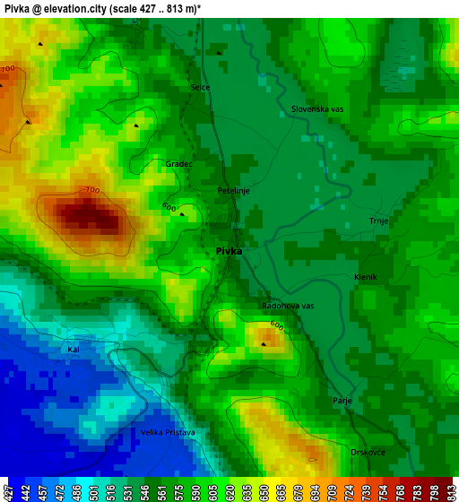
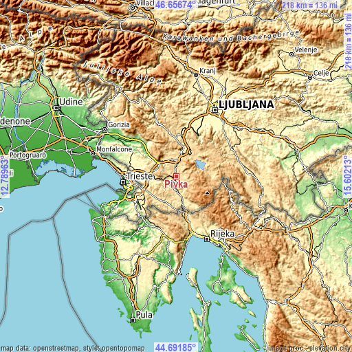
| \ | Map #1 | Topo.Map |
| Scale [m] | 427..813 m | × |
| Scale [ft] | 1401..2667 ft | × |
| Average | 568.1 m = 1864 ft | × |
| Width | 6.83 km = 4.2 mi | 218.5 km = 135.8 mi |
| Height | 6.83 km = 4.2 mi | 218.5 km = 135.8 mi |
| ↑Max Latitude | 45.713613° | 46.65674° |
| Latitude at center | 45.68292° | 45.68292° |
| ↓Min Latitude | 45.65221° | 44.69185° |
| ← Min Longitude | 14.151935° | 12.78963° |
| Longitude center | 14.19588° | 14.19588° |
| →Max Longitude | 14.239825° | 15.60213° |
Nearby cities:
Cities around Pivka sort by population:
• Postojna elevation 548 m
10.3 km,  8°
8°
• Logatec 473 m
25.8 km, 5°
• Sežana 370 m
25.2 km,  276°
276°
• Ilirska Bistrica 562 m
13.4 km,  163°
163°
• Cerknica 565 m
17.8 km,  46°
46°
• Borovnica 335 m
29 km,  26°
26°
• Rakek 526 m
17 km, 31°
• Vipava 110 m
25.6 km,  315°
315°
• Divača 438 m
17.5 km,  270°
270°
• Kozina 494 m
21.8 km,  248°
248°
• Leskova Dolina 834 m
21.7 km,  108°
108°
• Nova Vas 721 m
26 km,  67°
67°
Multilingual:
 En español:
Pivka elevación 550 m.
 En France:
Pivka élévation 550 m.


Sources and notes:
- [note 1] Map square and city borders are not equal. Map elevation data is calculated only from area inside that square.
- [src 1] Elevation data from geonames database provided with same terms of usage.
- [src 2] The elevation map of Pivka is generated using elevation data from NASA's 3 arcsec (90m) resolution SRTM data.
- [src 3] Base (background) map © OpenStreetMap contributors tiles are generated by Geofabrik and OpenTopoMap.
Copyright & License:
This Pivka Elevation Map is licensed under CC BY-SA. You may reuse any part from this page, if you give a proper credit by linking to this URL:
 More info on terms of use page.