Podvelka elevation
Podvelka, Slovenia elevation is 443 meters and Podvelka elevation in feet is 1453 ft above sea level [src 1]. Podvelka is a seat of a first-order administrative division (feature code) with elevation that is 129 meters (423 ft) bigger than average city elevation in Slovenia.
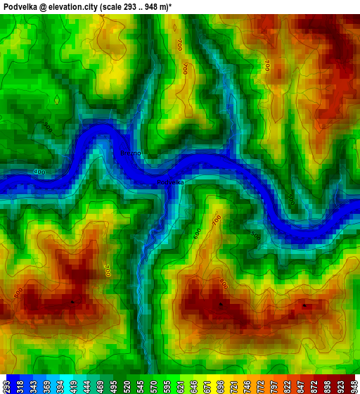
Below is the Elevation map of Podvelka, which displays elevation range with different colors. Scale of the first map is from 293 to 948 m (961 to 3110 ft) with average elevation of 604.2 meters (=1982 ft) [note 1]
These maps also provides idea of topography and contour of this city, they are displayed at different zoom levels. More info about maps, scale and edge coordinates you can find below images.
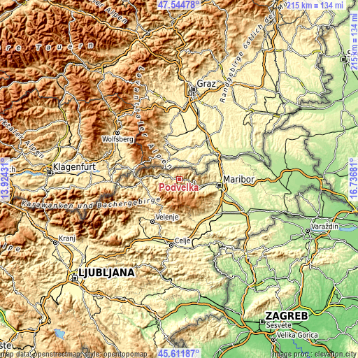
| \ | Map #1 | Topo.Map |
| Scale [m] | 293..948 m | × |
| Scale [ft] | 961..3110 ft | × |
| Average | 604.2 m = 1982 ft | × |
| Width | 6.72 km = 4.2 mi | 214.9 km = 133.5 mi |
| Height | 6.72 km = 4.2 mi | 214.9 km = 133.5 mi |
| ↑Max Latitude | 46.617133° | 47.54478° |
| Latitude at center | 46.58694° | 46.58694° |
| ↓Min Latitude | 46.55673° | 45.61187° |
| ← Min Longitude | 15.286615° | 13.92431° |
| Longitude center | 15.33056° | 15.33056° |
| →Max Longitude | 15.374505° | 16.73681° |
Nearby cities:
Cities around Podvelka sort by population:
• Ruše elevation 309 m
15.1 km,  110°
110°
• Radlje ob Dravi 366 m
8.5 km,  290°
290°
• Muta 334 m
12.9 km,  282°
282°
• Limbuš 297 m
19.7 km,  100°
100°
• Lovrenc na Pohorju 421 m
7 km,  137°
137°
• Mislinja 617 m
19 km,  211°
211°
• Vuzenica 350 m
12.5 km,  274°
274°
• Bresternica 313 m
18.8 km, 95°
• Bistrica ob Dravi 298 m
17.1 km, 102°
• Selnica ob Dravi 315 m
13.2 km, 108°
• Legen 828 m
16.8 km,  237°
237°
• Ribnica na Pohorju 669 m
7.3 km,  217°
217°
Multilingual:
 En español:
Podvelka elevación 443 m.
 En France:
Podvelka élévation 443 m.
 Auf Deutsch:
Podvelka höhe über dem Meeresspiegel ist 443 m.

Sources and notes:
- [note 1] Map square and city borders are not equal. Map elevation data is calculated only from area inside that square.
- [src 1] Elevation data from geonames database provided with same terms of usage.
- [src 2] The elevation map of Podvelka is generated using elevation data from NASA's 3 arcsec (90m) resolution SRTM data.
- [src 3] Base (background) map © OpenStreetMap contributors tiles are generated by Geofabrik and OpenTopoMap.
Copyright & License:
This Podvelka Elevation Map is licensed under CC BY-SA. You may reuse any part from this page, if you give a proper credit by linking to this URL:
 More info on terms of use page.