Bresternica elevation
Bresternica (Maribor), Slovenia elevation is 313 meters and Bresternica elevation in feet is 1027 ft above sea level [src 1]. Bresternica is a populated place (feature code) with elevation that is 1 meters (3 ft) smaller than average city elevation in Slovenia.
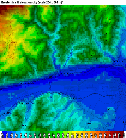
Below is the Elevation map of Bresternica, which displays elevation range with different colors. Scale of the first map is from 254 to 804 m (833 to 2638 ft) with average elevation of 388.6 meters (=1275 ft) [note 1]
These maps also provides idea of topography and contour of this city, they are displayed at different zoom levels. More info about maps, scale and edge coordinates you can find below images.
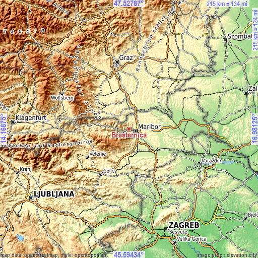
| \ | Map #1 | Topo.Map |
| Scale [m] | 254..804 m | × |
| Scale [ft] | 833..2638 ft | × |
| Average | 388.6 m = 1275 ft | × |
| Width | 6.72 km = 4.2 mi | 215 km = 133.6 mi |
| Height | 6.72 km = 4.2 mi | 215 km = 133.6 mi |
| ↑Max Latitude | 46.599923° | 47.52787° |
| Latitude at center | 46.56972° | 46.56972° |
| ↓Min Latitude | 46.5395° | 45.59434° |
| ← Min Longitude | 15.531055° | 14.16875° |
| Longitude center | 15.575° | 15.575° |
| →Max Longitude | 15.618945° | 16.98125° |
Nearby cities:
Cities around Bresternica sort by population:
• Maribor elevation 266 m
5.7 km,  106°
106°
• Ruše 309 m
5.6 km,  233°
233°
• Spodnje Hoče 276 m
9.6 km,  143°
143°
• Limbuš 297 m
1.9 km,  159°
159°
• Kamnica 289 m
3 km,  80°
80°
• Pekre 300 m
3 km,  147°
147°
• Rogoza 268 m
11.3 km,  133°
133°
• Bistrica ob Dravi 298 m
2.7 km, 229°
• Razvanje 297 m
7.7 km, 142°
• Selnica ob Dravi 315 m
6.5 km,  250°
250°
• Pesnica pri Mariboru 257 m
8.8 km,  61°
61°
• Zgornja Kungota 273 m
8.3 km,  21°
21°
Multilingual:
 En español:
Bresternica elevación 313 m.
 En France:
Bresternica élévation 313 m.
 Auf Deutsch:
Bresternica höhe über dem Meeresspiegel ist 313 m.

Sources and notes:
- [note 1] Map square and city borders are not equal. Map elevation data is calculated only from area inside that square.
- [src 1] Elevation data from geonames database provided with same terms of usage.
- [src 2] The elevation map of Bresternica is generated using elevation data from NASA's 3 arcsec (90m) resolution SRTM data.
- [src 3] Base (background) map © OpenStreetMap contributors tiles are generated by Geofabrik and OpenTopoMap.
Copyright & License:
This Bresternica Elevation Map is licensed under CC BY-SA. You may reuse any part from this page, if you give a proper credit by linking to this URL:
 More info on terms of use page.