Radovljica elevation
Radovljica, Slovenia elevation is 489 meters and Radovljica elevation in feet is 1604 ft above sea level [src 1]. Radovljica is a seat of a first-order administrative division (feature code) with elevation that is 175 meters (574 ft) bigger than average city elevation in Slovenia.
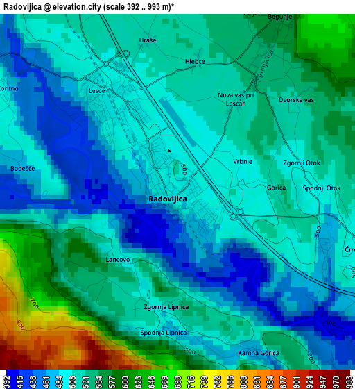
Below is the Elevation map of Radovljica, which displays elevation range with different colors. Scale of the first map is from 392 to 993 m (1286 to 3258 ft) with average elevation of 525 meters (=1722 ft) [note 1]
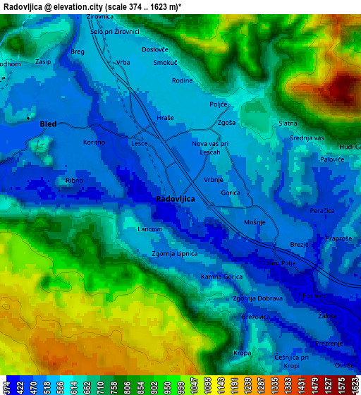
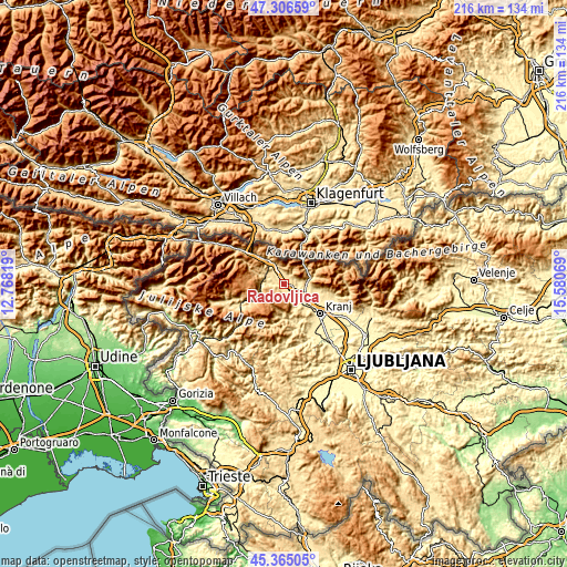
These maps also provides idea of topography and contour of this city, they are displayed at different zoom levels. More info about maps, scale and edge coordinates you can find below images.
| \ | Map #1 | Map #2 | Topo.Map |
| Scale [m] | 392..993 m | 374..1623 m | × |
| Scale [ft] | 1286..3258 ft | 1227..5325 ft | × |
| Average | 525 m = 1722 ft | 692.6 m = 2272 ft | × |
| Width | 6.75 km = 4.2 mi | 13.49 km = 8.4 mi | 215.9 km = 134.2 mi |
| Height | 6.75 km = 4.2 mi | 13.49 km = 8.4 mi | 215.9 km = 134.2 mi |
| ↑Max Latitude | 46.374768° | 46.405079° | 47.30659° |
| Latitude at center | 46.34444° | 46.34444° | 46.34444° |
| ↓Min Latitude | 46.314095° | 46.283734° | 45.36505° |
| ← Min Longitude | 14.130495° | 14.086549° | 12.76819° |
| Longitude center | 14.17444° | 14.17444° | 14.17444° |
| →Max Longitude | 14.218385° | 14.262331° | 15.58069° |
Nearby cities:
Cities around Radovljica sort by population:
• Jesenice elevation 560 m
12.6 km,  319°
319°
• Bled 505 m
5.4 km,  300°
300°
• Tržič 519 m
10.7 km,  78°
78°
• Železniki 513 m
13.3 km,  180°
180°
• Bistrica pri Tržiču 526 m
9.1 km, 82°
• Lesce 495 m
2.3 km,  325°
325°
• Koroška Bela 1284 m
12.6 km,  337°
337°
• Slovenski Javornik 542 m
11.3 km, 323°
• Golnik 660 m
12.3 km,  95°
95°
• Zasip 585 m
7.4 km, 316°
• Žirovnica 605 m
7.2 km, 338°
• Zgornje Gorje 609 m
9 km, 295°
Multilingual:
 En español:
Radovljica elevación 489 m.
 En France:
Radovljica élévation 489 m.
 Auf Deutsch:
Radovljica höhe über dem Meeresspiegel ist 489 m.

Sources and notes:
- [note 1] Map square and city borders are not equal. Map elevation data is calculated only from area inside that square.
- [src 1] Elevation data from geonames database provided with same terms of usage.
- [src 2] The elevation map of Radovljica is generated using elevation data from NASA's 3 arcsec (90m) resolution SRTM data.
- [src 3] Base (background) map © OpenStreetMap contributors tiles are generated by Geofabrik and OpenTopoMap.
Copyright & License:
This Radovljica Elevation Map is licensed under CC BY-SA. You may reuse any part from this page, if you give a proper credit by linking to this URL:
 More info on terms of use page.