Šentvid pri Stični elevation
Šentvid pri Stični (Ivančna Gorica), Slovenia elevation is 315 meters and Šentvid pri Stični elevation in feet is 1033 ft above sea level [src 1]. Šentvid pri Stični is a populated place (feature code) with elevation that is 1 meters (3 ft) bigger than average city elevation in Slovenia.
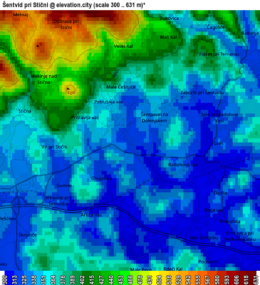
Below is the Elevation map of Šentvid pri Stični, which displays elevation range with different colors. Scale of the first map is from 300 to 631 m (984 to 2070 ft) with average elevation of 366.7 meters (=1203 ft) [note 1]
These maps also provides idea of topography and contour of this city, they are displayed at different zoom levels. More info about maps, scale and edge coordinates you can find below images.
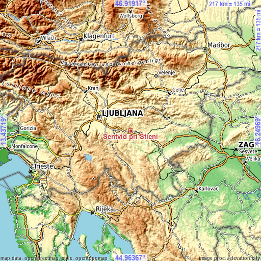
| \ | Map #1 | Topo.Map |
| Scale [m] | 300..631 m | × |
| Scale [ft] | 984..2070 ft | × |
| Average | 366.7 m = 1203 ft | × |
| Width | 6.79 km = 4.2 mi | 217.4 km = 135.1 mi |
| Height | 6.79 km = 4.2 mi | 217.4 km = 135.1 mi |
| ↑Max Latitude | 45.980586° | 46.91917° |
| Latitude at center | 45.95004° | 45.95004° |
| ↓Min Latitude | 45.919477° | 44.96367° |
| ← Min Longitude | 14.799495° | 13.43719° |
| Longitude center | 14.84344° | 14.84344° |
| →Max Longitude | 14.887385° | 16.24969° |
Nearby cities:
Cities around Šentvid pri Stični sort by population:
• Grosuplje elevation 344 m
14.3 km,  272°
272°
• Litija 248 m
12.2 km,  352°
352°
• Trebnje 281 m
14.7 km,  110°
110°
• Škofljica 302 m
20.9 km,  280°
280°
• Ivančna Gorica 327 m
3.3 km,  246°
246°
• Šmarje-Sap 355 m
18.1 km, 279°
• Šmartno pri Litiji 249 m
10.5 km,  0°
0°
• Mirna 272 m
16.9 km,  88°
88°
• Žužemberk 233 m
14.5 km,  152°
152°
• Velike Lašče 537 m
20.7 km,  230°
230°
• Videm 439 m
16 km, 226°
• Šentrupert 271 m
19.7 km,  81°
81°
Multilingual:
 En español:
Šentvid pri Stični elevación 315 m.
 En France:
Šentvid pri Stični élévation 315 m.
 Auf Deutsch:
Šentvid pri Stični höhe über dem Meeresspiegel ist 315 m.
 На русском:
Šentvid pri Stični высота над уровнем моря 315 м
Sources and notes:
- [note 1] Map square and city borders are not equal. Map elevation data is calculated only from area inside that square.
- [src 1] Elevation data from geonames database provided with same terms of usage.
- [src 2] The elevation map of Šentvid pri Stični is generated using elevation data from NASA's 3 arcsec (90m) resolution SRTM data.
- [src 3] Base (background) map © OpenStreetMap contributors tiles are generated by Geofabrik and OpenTopoMap.
Copyright & License:
This Šentvid pri Stični Elevation Map is licensed under CC BY-SA. You may reuse any part from this page, if you give a proper credit by linking to this URL:
 More info on terms of use page.