Šmartno pri Litiji elevation
Šmartno pri Litiji, Slovenia elevation is 249 meters and Šmartno pri Litiji elevation in feet is 817 ft above sea level [src 1]. Šmartno pri Litiji is a seat of a first-order administrative division (feature code) with elevation that is 65 meters (213 ft) smaller than average city elevation in Slovenia.
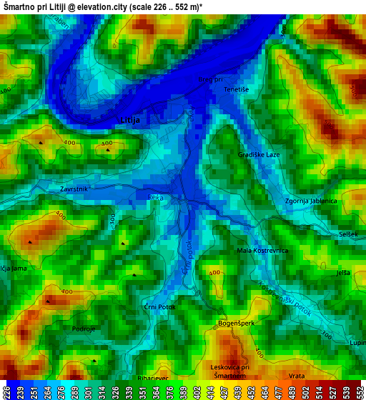
Below is the Elevation map of Šmartno pri Litiji, which displays elevation range with different colors. Scale of the first map is from 226 to 552 m (741 to 1811 ft) with average elevation of 342.4 meters (=1123 ft) [note 1]
These maps also provides idea of topography and contour of this city, they are displayed at different zoom levels. More info about maps, scale and edge coordinates you can find below images.
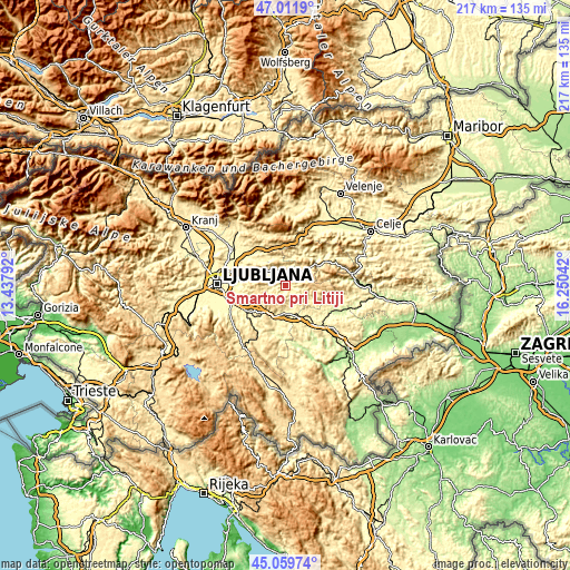
| \ | Map #1 | Topo.Map |
| Scale [m] | 226..552 m | × |
| Scale [ft] | 741..1811 ft | × |
| Average | 342.4 m = 1123 ft | × |
| Width | 6.78 km = 4.2 mi | 217.1 km = 134.9 mi |
| Height | 6.78 km = 4.2 mi | 217 km = 134.8 mi |
| ↑Max Latitude | 46.074934° | 47.0119° |
| Latitude at center | 46.04444° | 46.04444° |
| ↓Min Latitude | 46.013929° | 45.05974° |
| ← Min Longitude | 14.800225° | 13.43792° |
| Longitude center | 14.84417° | 14.84417° |
| →Max Longitude | 14.888115° | 16.25042° |
Nearby cities:
Cities around Šmartno pri Litiji sort by population:
• Grosuplje elevation 344 m
17.4 km,  235°
235°
• Litija 248 m
2.3 km,  313°
313°
• Zagorje ob Savi 244 m
15.3 km,  50°
50°
• Ivančna Gorica 327 m
12.2 km,  194°
194°
• Kisovec 277 m
14 km,  41°
41°
• Šmarje-Sap 355 m
19.5 km,  247°
247°
• Mirna 272 m
19.5 km,  120°
120°
• Izlake 315 m
14.3 km,  34°
34°
• Šentvid pri Stični 315 m
10.5 km,  180°
180°
• Moravče 383 m
12.8 km,  323°
323°
• Lukovica pri Domžalah 341 m
18.2 km, 319°
• Dol pri Ljubljani 278 m
19.4 km,  284°
284°
Multilingual:
 En español:
Šmartno pri Litiji elevación 249 m.
 En France:
Šmartno pri Litiji élévation 249 m.
 Auf Deutsch:
Sankt Martin höhe über dem Meeresspiegel ist 249 m.
 На русском:
Šmartno pri Litiji высота над уровнем моря 249 м
Sources and notes:
- [note 1] Map square and city borders are not equal. Map elevation data is calculated only from area inside that square.
- [src 1] Elevation data from geonames database provided with same terms of usage.
- [src 2] The elevation map of Šmartno pri Litiji is generated using elevation data from NASA's 3 arcsec (90m) resolution SRTM data.
- [src 3] Base (background) map © OpenStreetMap contributors tiles are generated by Geofabrik and OpenTopoMap.
Copyright & License:
This Šmartno pri Litiji Elevation Map is licensed under CC BY-SA. You may reuse any part from this page, if you give a proper credit by linking to this URL:
 More info on terms of use page.