Zgornje Bitnje elevation
Zgornje Bitnje (Kranj), Slovenia elevation is 386 meters and Zgornje Bitnje elevation in feet is 1266 ft above sea level [src 1]. Zgornje Bitnje is a populated place (feature code) with elevation that is 72 meters (236 ft) bigger than average city elevation in Slovenia.
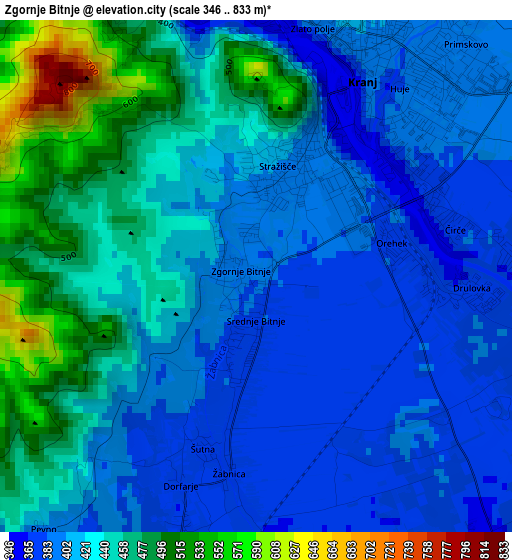
Below is the Elevation map of Zgornje Bitnje, which displays elevation range with different colors. Scale of the first map is from 346 to 833 m (1135 to 2733 ft) with average elevation of 425.7 meters (=1397 ft) [note 1]
These maps also provides idea of topography and contour of this city, they are displayed at different zoom levels. More info about maps, scale and edge coordinates you can find below images.
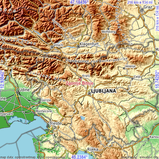
| \ | Map #1 | Topo.Map |
| Scale [m] | 346..833 m | × |
| Scale [ft] | 1135..2733 ft | × |
| Average | 425.7 m = 1397 ft | × |
| Width | 6.76 km = 4.2 mi | 216.4 km = 134.5 mi |
| Height | 6.76 km = 4.2 mi | 216.4 km = 134.5 mi |
| ↑Max Latitude | 46.250397° | 47.18436° |
| Latitude at center | 46.22° | 46.22° |
| ↓Min Latitude | 46.189586° | 45.2384° |
| ← Min Longitude | 14.292725° | 12.93042° |
| Longitude center | 14.33667° | 14.33667° |
| →Max Longitude | 14.380615° | 15.74292° |
Nearby cities:
Cities around Zgornje Bitnje sort by population:
• Kranj elevation 387 m
2.6 km,  34°
34°
• Škofja Loka 360 m
6.5 km,  201°
201°
• Medvode 318 m
10.4 km,  146°
146°
• Šenčur 408 m
7 km,  66°
66°
• Britof 415 m
6.1 km,  42°
42°
• Naklo 408 m
6.1 km,  345°
345°
• Kokrica 403 m
5.9 km,  18°
18°
• Mlaka pri Kranju 410 m
7.1 km,  8°
8°
• Zgornje Pirniče 343 m
11.3 km,  139°
139°
• Sv. Duh 361 m
4.1 km,  183°
183°
• Hrastje 370 m
4.9 km,  94°
94°
• Preddvor 488 m
11.3 km, 35°
Multilingual:
 En español:
Zgornje Bitnje elevación 386 m.
 En France:
Zgornje Bitnje élévation 386 m.
 Auf Deutsch:
Zgornje Bitnje höhe über dem Meeresspiegel ist 386 m.

Sources and notes:
- [note 1] Map square and city borders are not equal. Map elevation data is calculated only from area inside that square.
- [src 1] Elevation data from geonames database provided with same terms of usage.
- [src 2] The elevation map of Zgornje Bitnje is generated using elevation data from NASA's 3 arcsec (90m) resolution SRTM data.
- [src 3] Base (background) map © OpenStreetMap contributors tiles are generated by Geofabrik and OpenTopoMap.
Copyright & License:
This Zgornje Bitnje Elevation Map is licensed under CC BY-SA. You may reuse any part from this page, if you give a proper credit by linking to this URL:
 More info on terms of use page.