Holmsund elevation
Holmsund (Västerbotten, Umeå Kommun), Sweden elevation is 12 meters and Holmsund elevation in feet is 39 ft above sea level [src 1]. Holmsund is a populated place (feature code) with elevation that is 63 meters (207 ft) smaller than average city elevation in Sweden.
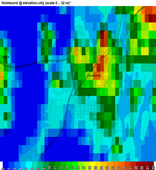
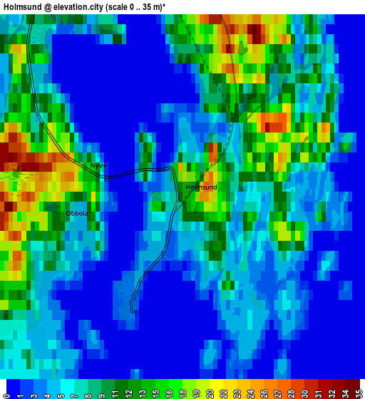
Below is the Elevation map of Holmsund, which displays elevation range with different colors. Scale of the first map is from 0 to 32 m (0 to 105 ft) with average elevation of 6.4 meters (=21 ft) [note 1]
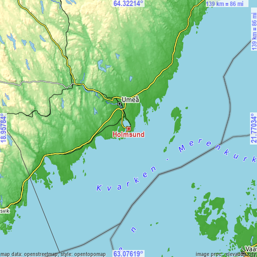
These maps also provides idea of topography and contour of this city, they are displayed at different zoom levels. More info about maps, scale and edge coordinates you can find below images.
| \ | Map #1 | Map #2 | Topo.Map |
| Scale [m] | 0..32 m | 0..35 m | × |
| Scale [ft] | 0..105 ft | 0..115 ft | × |
| Average | 6.4 m = 21 ft | 7.1 m = 23 ft | × |
| Width | 4.33 km = 2.7 mi | 8.66 km = 5.4 mi | 138.5 km = 86.1 mi |
| Height | 4.33 km = 2.7 mi | 8.66 km = 5.4 mi | 138.5 km = 86.1 mi |
| ↑Max Latitude | 63.72548° | 63.744927° | 64.32214° |
| Latitude at center | 63.70602° | 63.70602° | 63.70602° |
| ↓Min Latitude | 63.686547° | 63.66706° | 63.07619° |
| ← Min Longitude | 20.320145° | 20.276199° | 18.95784° |
| Longitude center | 20.36409° | 20.36409° | 20.36409° |
| →Max Longitude | 20.408035° | 20.451981° | 21.77034° |
Nearby cities:
Cities around Holmsund sort by population:
• Umeå elevation 24 m
14.5 km,  339°
339°
• Vännäs 81 m
37.2 km,  306°
306°
• Sävar 41 m
23.8 km,  22°
22°
• Nordmaling 20 m
45.2 km,  250°
250°
• Hörnefors 2 m
24.3 km, 247°
• Röbäck 30 m
14.3 km,  323°
323°
• Obbola 1 m
2.4 km, 254°
• Robertsfors 62 m
59.1 km, 23°
• Ersmark 44 m
19.9 km,  353°
353°
• Vännäsby 81 m
35.3 km, 311°
• Täfteå 17 m
15.9 km, 20°
• Bjurholm 173 m
61.7 km,  293°
293°
Multilingual:
 En español:
Holmsund elevación 12 m.
 En France:
Holmsund élévation 12 m.


Sources and notes:
- [note 1] Map square and city borders are not equal. Map elevation data is calculated only from area inside that square.
- [src 1] Elevation data from geonames database provided with same terms of usage.
- [src 2] The elevation map of Holmsund is generated using GMTED2010 database with 7.5 arcsec (225m) resolution.
- [src 3] Base (background) map © OpenStreetMap contributors tiles are generated by Geofabrik and OpenTopoMap.
Copyright & License:
This Holmsund Elevation Map is licensed under CC BY-SA. You may reuse any part from this page, if you give a proper credit by linking to this URL:
 More info on terms of use page.