Bjurholm elevation
Bjurholm (Västerbotten, Bjurholms Kommun), Sweden elevation is 173 meters and Bjurholm elevation in feet is 568 ft above sea level [src 1]. Bjurholm is a seat of a second-order administrative division (feature code) with elevation that is 98 meters (322 ft) bigger than average city elevation in Sweden.
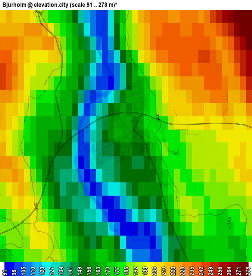
Below is the Elevation map of Bjurholm, which displays elevation range with different colors. Scale of the first map is from 91 to 278 m (299 to 912 ft) with average elevation of 179.8 meters (=590 ft) [note 1]
These maps also provides idea of topography and contour of this city, they are displayed at different zoom levels. More info about maps, scale and edge coordinates you can find below images.
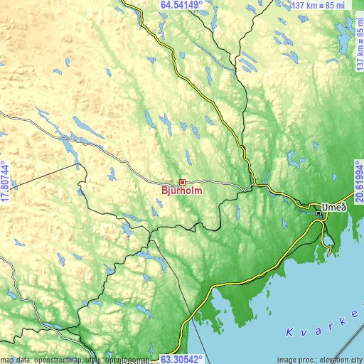
| \ | Map #1 | Topo.Map |
| Scale [m] | 91..278 m | × |
| Scale [ft] | 299..912 ft | × |
| Average | 179.8 m = 590 ft | × |
| Width | 4.29 km = 2.7 mi | 137.4 km = 85.4 mi |
| Height | 4.29 km = 2.7 mi | 137.4 km = 85.4 mi |
| ↑Max Latitude | 63.949576° | 64.54149° |
| Latitude at center | 63.93027° | 63.93027° |
| ↓Min Latitude | 63.910951° | 63.30542° |
| ← Min Longitude | 19.169745° | 17.80744° |
| Longitude center | 19.21369° | 19.21369° |
| →Max Longitude | 19.257635° | 20.61994° |
Nearby cities:
Cities around Bjurholm sort by population:
• Umeå elevation 24 m
52.4 km,  102°
102°
• Holmsund 12 m
61.7 km,  113°
113°
• Vännäs 81 m
26.7 km, 95°
• Sävar 41 m
65.4 km,  92°
92°
• Nordmaling 20 m
42.7 km,  160°
160°
• Hörnefors 2 m
48.3 km,  135°
135°
• Röbäck 30 m
49.6 km, 105°
• Vindeln 188 m
38.9 km,  39°
39°
• Obbola 1 m
59.9 km,  115°
115°
• Ersmark 44 m
54.2 km, 95°
• Vännäsby 81 m
29.9 km, 93°
• Täfteå 17 m
62.7 km, 99°
Multilingual:
 En español:
Bjurholm elevación 173 m.
 En France:
Bjurholm élévation 173 m.
 Auf Deutsch:
Bjurholm höhe über dem Meeresspiegel ist 173 m.

Sources and notes:
- [note 1] Map square and city borders are not equal. Map elevation data is calculated only from area inside that square.
- [src 1] Elevation data from geonames database provided with same terms of usage.
- [src 2] The elevation map of Bjurholm is generated using GMTED2010 database with 7.5 arcsec (225m) resolution.
- [src 3] Base (background) map © OpenStreetMap contributors tiles are generated by Geofabrik and OpenTopoMap.
Copyright & License:
This Bjurholm Elevation Map is licensed under CC BY-SA. You may reuse any part from this page, if you give a proper credit by linking to this URL:
 More info on terms of use page.