Alafors elevation
Alafors (Västra Götaland, Ale Kommun), Sweden elevation is 13 meters and Alafors elevation in feet is 43 ft above sea level [src 1]. Alafors is a seat of a second-order administrative division (feature code) with elevation that is 62 meters (203 ft) smaller than average city elevation in Sweden.
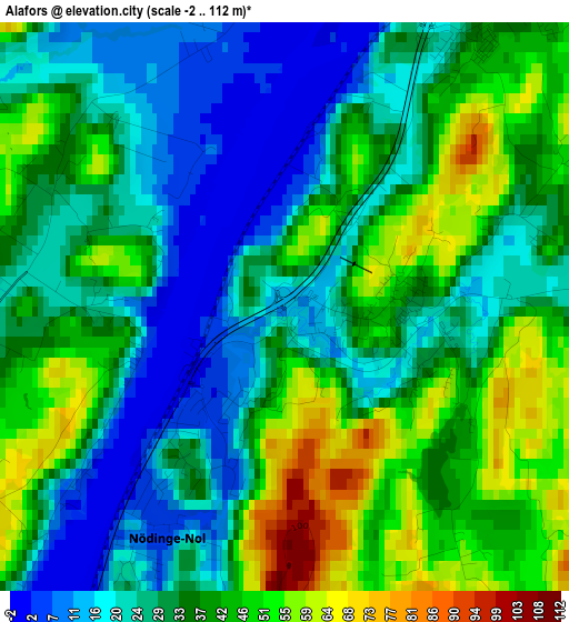
Below is the Elevation map of Alafors, which displays elevation range with different colors. Scale of the first map is from -2 to 112 m (-7 to 367 ft) with average elevation of 34.2 meters (=112 ft) [note 1]
These maps also provides idea of topography and contour of this city, they are displayed at different zoom levels. More info about maps, scale and edge coordinates you can find below images.
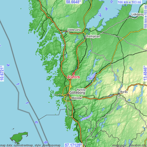
| \ | Map #1 | Topo.Map |
| Scale [m] | -2..112 m | × |
| Scale [ft] | -7..367 ft | × |
| Average | 34.2 m = 112 ft | × |
| Width | 5.19 km = 3.2 mi | 166.1 km = 103.2 mi |
| Height | 5.19 km = 3.2 mi | 166 km = 103.1 mi |
| ↑Max Latitude | 57.949118° | 58.6648° |
| Latitude at center | 57.92579° | 57.92579° |
| ↓Min Latitude | 57.902447° | 57.17125° |
| ← Min Longitude | 12.034405° | 10.6721° |
| Longitude center | 12.07835° | 12.07835° |
| →Max Longitude | 12.122295° | 13.4846° |
Nearby cities:
Cities around Alafors sort by population:
• Kungälv elevation 13 m
8.4 km,  223°
223°
• Gårdsten 103 m
13.8 km,  192°
192°
• Lövgärdet 93 m
12.5 km, 190°
• Surte 8 m
11.8 km,  198°
198°
• Älvängen 8 m
4.5 km,  36°
36°
• Rannebergen 115 m
13.7 km,  181°
181°
• Sålanda 21 m
10.4 km,  51°
51°
• Olofstorp 72 m
14.6 km,  157°
157°
• Skepplanda 7 m
9.6 km, 48°
• Kode 27 m
13.6 km,  277°
277°
• Lödöse 30 m
12.5 km,  22°
22°
• Diseröd 63 m
3.1 km,  271°
271°
Multilingual:
 En español:
Alafors elevación 13 m.
 En France:
Alafors élévation 13 m.


Sources and notes:
- [note 1] Map square and city borders are not equal. Map elevation data is calculated only from area inside that square.
- [src 1] Elevation data from geonames database provided with same terms of usage.
- [src 2] The elevation map of Alafors is generated using elevation data from NASA's 3 arcsec (90m) resolution SRTM data.
- [src 3] Base (background) map © OpenStreetMap contributors tiles are generated by Geofabrik and OpenTopoMap.
Copyright & License:
This Alafors Elevation Map is licensed under CC BY-SA. You may reuse any part from this page, if you give a proper credit by linking to this URL:
 More info on terms of use page.