Sålanda elevation
Sålanda (Västra Götaland, Ale Kommun), Sweden elevation is 21 meters and Sålanda elevation in feet is 69 ft above sea level [src 1]. Sålanda is a populated place (feature code) with elevation that is 54 meters (177 ft) smaller than average city elevation in Sweden.
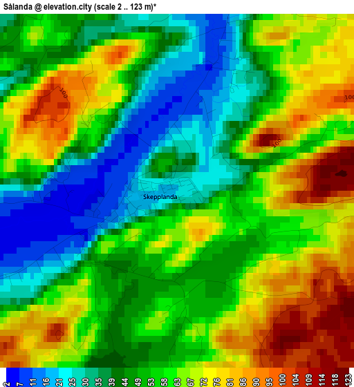
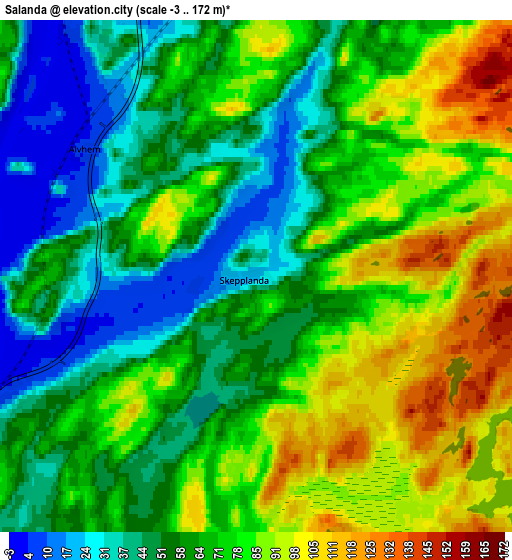
Below is the Elevation map of Sålanda, which displays elevation range with different colors. Scale of the first map is from 2 to 123 m (7 to 404 ft) with average elevation of 55.5 meters (=182 ft) [note 1]
These maps also provides idea of topography and contour of this city, they are displayed at different zoom levels. More info about maps, scale and edge coordinates you can find below images.
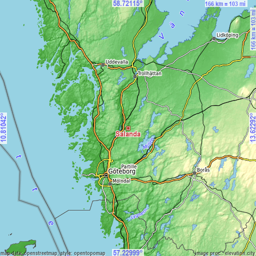
| \ | Map #1 | Map #2 | Topo.Map |
| Scale [m] | 2..123 m | -3..172 m | × |
| Scale [ft] | 7..404 ft | -10..564 ft | × |
| Average | 55.5 m = 182 ft | 67.6 m = 222 ft | × |
| Width | 5.18 km = 3.2 mi | 10.36 km = 6.4 mi | 165.8 km = 103 mi |
| Height | 5.18 km = 3.2 mi | 10.36 km = 6.4 mi | 165.8 km = 103 mi |
| ↑Max Latitude | 58.006621° | 58.029896° | 58.72115° |
| Latitude at center | 57.98333° | 57.98333° | 57.98333° |
| ↓Min Latitude | 57.960024° | 57.936703° | 57.22999° |
| ← Min Longitude | 12.172725° | 12.128779° | 10.81042° |
| Longitude center | 12.21667° | 12.21667° | 12.21667° |
| →Max Longitude | 12.260615° | 12.304561° | 13.62292° |
Nearby cities:
Cities around Sålanda sort by population:
• Kungälv elevation 13 m
18.7 km,  228°
228°
• Gråbo 73 m
17.1 km,  163°
163°
• Älvängen 8 m
6.1 km,  243°
243°
• Lilla Edet 41 m
17.4 km,  343°
343°
• Skepplanda 7 m
1 km,  270°
270°
• Ingared 79 m
19.5 km,  134°
134°
• Lödöse 30 m
6.2 km,  326°
326°
• Diseröd 63 m
12.9 km, 240°
• Björboholm 68 m
14 km,  152°
152°
• Olstorp 98 m
18.2 km,  168°
168°
• Göta 46 m
14.2 km, 344°
• Alafors 13 m
10.4 km, 231°
Multilingual:
 En español:
Sålanda elevación 21 m.
 En France:
Sålanda élévation 21 m.


Sources and notes:
- [note 1] Map square and city borders are not equal. Map elevation data is calculated only from area inside that square.
- [src 1] Elevation data from geonames database provided with same terms of usage.
- [src 2] The elevation map of Sålanda is generated using elevation data from NASA's 3 arcsec (90m) resolution SRTM data.
- [src 3] Base (background) map © OpenStreetMap contributors tiles are generated by Geofabrik and OpenTopoMap.
Copyright & License:
This Sålanda Elevation Map is licensed under CC BY-SA. You may reuse any part from this page, if you give a proper credit by linking to this URL:
 More info on terms of use page.