Alingsås elevation
Alingsås (Västra Götaland, Alingsås Kommun), Sweden elevation is 66 meters and Alingsås elevation in feet is 217 ft above sea level [src 1]. Alingsås is a seat of a second-order administrative division (feature code) with elevation that is 9 meters (30 ft) smaller than average city elevation in Sweden.
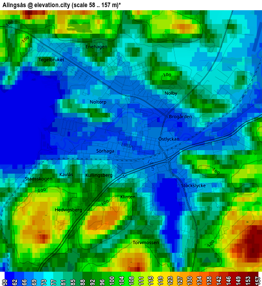
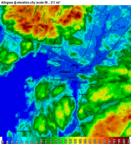
Below is the Elevation map of Alingsås, which displays elevation range with different colors. Scale of the first map is from 58 to 157 m (190 to 515 ft) with average elevation of 85.1 meters (=279 ft) [note 1]
These maps also provides idea of topography and contour of this city, they are displayed at different zoom levels. More info about maps, scale and edge coordinates you can find below images.
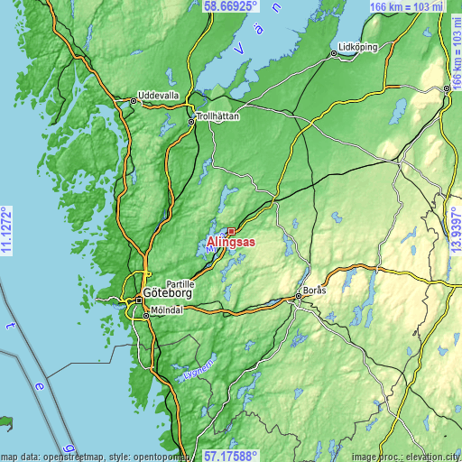
| \ | Map #1 | Map #2 | Topo.Map |
| Scale [m] | 58..157 m | 58..211 m | × |
| Scale [ft] | 190..515 ft | 190..692 ft | × |
| Average | 85.1 m = 279 ft | 103.5 m = 340 ft | × |
| Width | 5.19 km = 3.2 mi | 10.38 km = 6.4 mi | 166 km = 103.1 mi |
| Height | 5.19 km = 3.2 mi | 10.38 km = 6.4 mi | 166 km = 103.1 mi |
| ↑Max Latitude | 57.953655° | 57.976965° | 58.66925° |
| Latitude at center | 57.93033° | 57.93033° | 57.93033° |
| ↓Min Latitude | 57.90699° | 57.883634° | 57.17588° |
| ← Min Longitude | 12.489505° | 12.445559° | 11.1272° |
| Longitude center | 12.53345° | 12.53345° | 12.53345° |
| →Max Longitude | 12.577395° | 12.621341° | 13.9397° |
Nearby cities:
Cities around Alingsås sort by population:
• Lerum elevation 20 m
23.7 km,  221°
221°
• Gråbo 73 m
17.3 km,  232°
232°
• Vårgårda 109 m
20.1 km,  53°
53°
• Älvängen 8 m
24.4 km,  277°
277°
• Sålanda 21 m
19.6 km,  287°
287°
• Stenkullen 54 m
19.8 km, 220°
• Skepplanda 7 m
20.5 km, 286°
• Jonstorp 107 m
13.3 km, 54°
• Ingared 79 m
9.2 km,  211°
211°
• Sollebrunn 77 m
20.7 km,  359°
359°
• Björboholm 68 m
13.9 km,  241°
241°
• Olstorp 98 m
19.3 km, 231°
Multilingual:
 En español:
Alingsås elevación 66 m.
 En France:
Alingsås élévation 66 m.


Sources and notes:
- [note 1] Map square and city borders are not equal. Map elevation data is calculated only from area inside that square.
- [src 1] Elevation data from geonames database provided with same terms of usage.
- [src 2] The elevation map of Alingsås is generated using elevation data from NASA's 3 arcsec (90m) resolution SRTM data.
- [src 3] Base (background) map © OpenStreetMap contributors tiles are generated by Geofabrik and OpenTopoMap.
Copyright & License:
This Alingsås Elevation Map is licensed under CC BY-SA. You may reuse any part from this page, if you give a proper credit by linking to this URL:
 More info on terms of use page.