Älmhult elevation
Älmhult (Kronoberg, Älmhults Kommun), Sweden elevation is 144 meters and Älmhult elevation in feet is 472 ft above sea level [src 1]. Älmhult is a seat of a second-order administrative division (feature code) with elevation that is 69 meters (226 ft) bigger than average city elevation in Sweden.
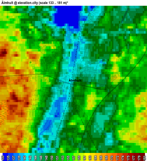
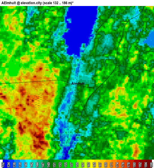
Below is the Elevation map of Älmhult, which displays elevation range with different colors. Scale of the first map is from 133 to 181 m (436 to 594 ft) with average elevation of 152.4 meters (=500 ft) [note 1]
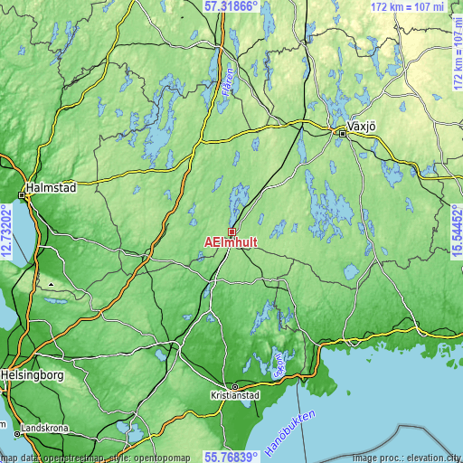
These maps also provides idea of topography and contour of this city, they are displayed at different zoom levels. More info about maps, scale and edge coordinates you can find below images.
| \ | Map #1 | Map #2 | Topo.Map |
| Scale [m] | 133..181 m | 132..186 m | × |
| Scale [ft] | 436..594 ft | 433..610 ft | × |
| Average | 152.4 m = 500 ft | 154.1 m = 506 ft | × |
| Width | 5.39 km = 3.3 mi | 10.77 km = 6.7 mi | 172.4 km = 107.1 mi |
| Height | 5.39 km = 3.3 mi | 10.77 km = 6.7 mi | 172.4 km = 107.1 mi |
| ↑Max Latitude | 56.575674° | 56.599873° | 57.31866° |
| Latitude at center | 56.55146° | 56.55146° | 56.55146° |
| ↓Min Latitude | 56.52723° | 56.502985° | 55.76839° |
| ← Min Longitude | 14.094325° | 14.050379° | 12.73202° |
| Longitude center | 14.13827° | 14.13827° | 14.13827° |
| →Max Longitude | 14.182215° | 14.226161° | 15.54452° |
Nearby cities:
Cities around Älmhult sort by population:
• Ljungby elevation 142 m
33.6 km,  338°
338°
• Osby 85 m
20.9 km,  205°
205°
• Markaryd 109 m
34.7 km,  253°
253°
• Hittarp 74 m
29.8 km,  182°
182°
• Broby 45 m
33.1 km,  186°
186°
• Strömsnäsbruk 124 m
25.8 km,  269°
269°
• Lönsboda 140 m
20.1 km,  146°
146°
• Vislanda 164 m
32.1 km,  36°
36°
• Hästveda 68 m
32.2 km,  202°
202°
• Ryd 147 m
34.7 km,  105°
105°
• Glimåkra 72 m
28 km, 180°
• Sibbhult 72 m
31.9 km,  173°
173°
Multilingual:
 En español:
Älmhult elevación 144 m.
 En France:
Älmhult élévation 144 m.


Sources and notes:
- [note 1] Map square and city borders are not equal. Map elevation data is calculated only from area inside that square.
- [src 1] Elevation data from geonames database provided with same terms of usage.
- [src 2] The elevation map of Älmhult is generated using elevation data from NASA's 3 arcsec (90m) resolution SRTM data.
- [src 3] Base (background) map © OpenStreetMap contributors tiles are generated by Geofabrik and OpenTopoMap.
Copyright & License:
This Älmhult Elevation Map is licensed under CC BY-SA. You may reuse any part from this page, if you give a proper credit by linking to this URL:
 More info on terms of use page.