Hästveda elevation
Hästveda (Skåne, Hässleholms Kommun), Sweden elevation is 68 meters and Hästveda elevation in feet is 223 ft above sea level [src 1]. Hästveda is a populated place (feature code) with elevation that is 7 meters (23 ft) smaller than average city elevation in Sweden.
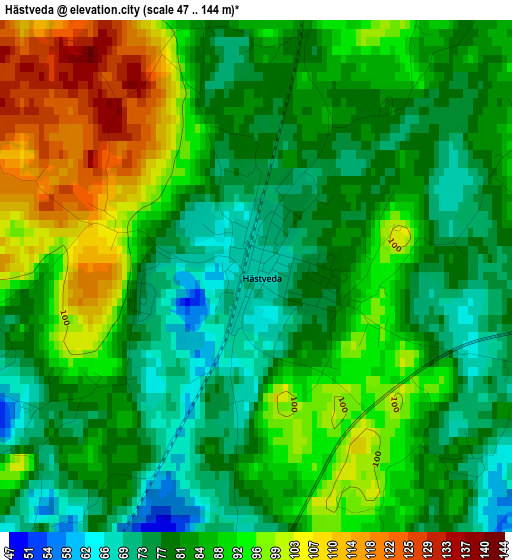
Below is the Elevation map of Hästveda, which displays elevation range with different colors. Scale of the first map is from 47 to 144 m (154 to 472 ft) with average elevation of 85.8 meters (=281 ft) [note 1]
These maps also provides idea of topography and contour of this city, they are displayed at different zoom levels. More info about maps, scale and edge coordinates you can find below images.
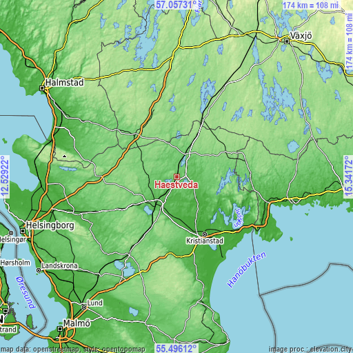
| \ | Map #1 | Topo.Map |
| Scale [m] | 47..144 m | × |
| Scale [ft] | 154..472 ft | × |
| Average | 85.8 m = 281 ft | × |
| Width | 5.42 km = 3.4 mi | 173.6 km = 107.9 mi |
| Height | 5.42 km = 3.4 mi | 173.6 km = 107.9 mi |
| ↑Max Latitude | 56.309065° | 57.05731° |
| Latitude at center | 56.28468° | 56.28468° |
| ↓Min Latitude | 56.26028° | 55.49612° |
| ← Min Longitude | 13.891525° | 12.52922° |
| Longitude center | 13.93547° | 13.93547° |
| →Max Longitude | 13.979415° | 15.34172° |
Nearby cities:
Cities around Hästveda sort by population:
• Hässleholm elevation 58 m
17.4 km,  216°
216°
• Osby 85 m
11.4 km,  18°
18°
• Vinslöv 31 m
20.6 km,  183°
183°
• Hittarp 74 m
11.2 km,  90°
90°
• Knislinge 23 m
14.5 km,  140°
140°
• Broby 45 m
9.4 km,  110°
110°
• Bjärnum 95 m
13.8 km,  272°
272°
• Vittsjö 107 m
18.2 km,  291°
291°
• Glimåkra 72 m
12.3 km,  82°
82°
• Sibbhult 72 m
16.5 km,  96°
96°
• Hanaskog 24 m
16.9 km, 144°
• Tormestorp 71 m
22.4 km,  211°
211°
Multilingual:
 En español:
Hästveda elevación 68 m.
 En France:
Hästveda élévation 68 m.


Sources and notes:
- [note 1] Map square and city borders are not equal. Map elevation data is calculated only from area inside that square.
- [src 1] Elevation data from geonames database provided with same terms of usage.
- [src 2] The elevation map of Hästveda is generated using elevation data from NASA's 3 arcsec (90m) resolution SRTM data.
- [src 3] Base (background) map © OpenStreetMap contributors tiles are generated by Geofabrik and OpenTopoMap.
Copyright & License:
This Hästveda Elevation Map is licensed under CC BY-SA. You may reuse any part from this page, if you give a proper credit by linking to this URL:
 More info on terms of use page.