Herrljunga elevation
Herrljunga (Västra Götaland, Herrljunga Kommun), Sweden elevation is 112 meters and Herrljunga elevation in feet is 367 ft above sea level [src 1]. Herrljunga is a seat of a second-order administrative division (feature code) with elevation that is 37 meters (121 ft) bigger than average city elevation in Sweden.
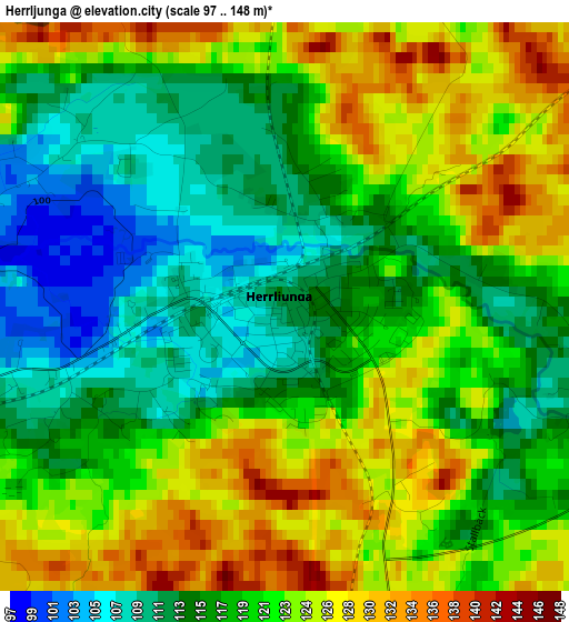
Below is the Elevation map of Herrljunga, which displays elevation range with different colors. Scale of the first map is from 97 to 148 m (318 to 486 ft) with average elevation of 119.4 meters (=392 ft) [note 1]
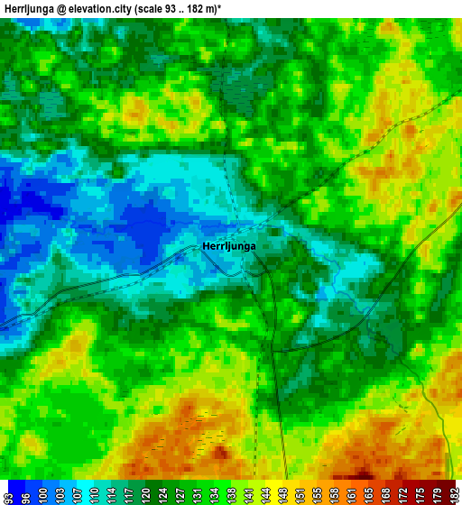
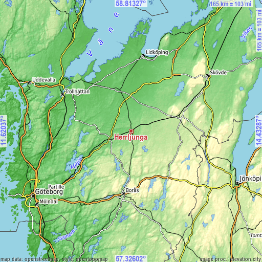
These maps also provides idea of topography and contour of this city, they are displayed at different zoom levels. More info about maps, scale and edge coordinates you can find below images.
| \ | Map #1 | Map #2 | Topo.Map |
| Scale [m] | 97..148 m | 93..182 m | × |
| Scale [ft] | 318..486 ft | 305..597 ft | × |
| Average | 119.4 m = 392 ft | 129.1 m = 424 ft | × |
| Width | 5.17 km = 3.2 mi | 10.33 km = 6.4 mi | 165.4 km = 102.8 mi |
| Height | 5.17 km = 3.2 mi | 10.33 km = 6.4 mi | 165.3 km = 102.7 mi |
| ↑Max Latitude | 58.10062° | 58.123834° | 58.81327° |
| Latitude at center | 58.07739° | 58.07739° | 58.07739° |
| ↓Min Latitude | 58.054145° | 58.030886° | 57.32602° |
| ← Min Longitude | 12.982675° | 12.938729° | 11.62037° |
| Longitude center | 13.02662° | 13.02662° | 13.02662° |
| →Max Longitude | 13.070565° | 13.114511° | 14.43287° |
Nearby cities:
Cities around Herrljunga sort by population:
• Alingsås elevation 66 m
33.3 km,  240°
240°
• Falköping 217 m
32.6 km,  70°
70°
• Fristad 152 m
28.1 km,  181°
181°
• Vårgårda 109 m
13.6 km,  250°
250°
• Vara 84 m
21 km,  348°
348°
• Grästorp 64 m
34.8 km,  324°
324°
• Nossebro 88 m
22 km,  304°
304°
• Jonstorp 107 m
20.2 km, 244°
• Floby 177 m
19.1 km, 70°
• Sollebrunn 77 m
29.3 km,  278°
278°
• Kvänum 81 m
26.4 km,  20°
20°
• Annelund 176 m
10.3 km,  163°
163°
Multilingual:
 En español:
Herrljunga elevación 112 m.
 En France:
Herrljunga élévation 112 m.
 Auf Deutsch:
Herrljunga höhe über dem Meeresspiegel ist 112 m.

Sources and notes:
- [note 1] Map square and city borders are not equal. Map elevation data is calculated only from area inside that square.
- [src 1] Elevation data from geonames database provided with same terms of usage.
- [src 2] The elevation map of Herrljunga is generated using elevation data from NASA's 3 arcsec (90m) resolution SRTM data.
- [src 3] Base (background) map © OpenStreetMap contributors tiles are generated by Geofabrik and OpenTopoMap.
Copyright & License:
This Herrljunga Elevation Map is licensed under CC BY-SA. You may reuse any part from this page, if you give a proper credit by linking to this URL:
 More info on terms of use page.