Katrineholm elevation
Katrineholm (Södermanland, Katrineholms Kommun), Sweden elevation is 51 meters and Katrineholm elevation in feet is 167 ft above sea level [src 1]. Katrineholm is a seat of a second-order administrative division (feature code) with elevation that is 24 meters (79 ft) smaller than average city elevation in Sweden.
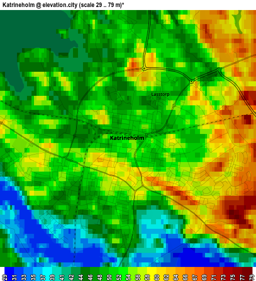
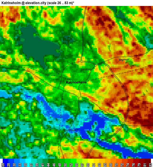
Below is the Elevation map of Katrineholm, which displays elevation range with different colors. Scale of the first map is from 29 to 79 m (95 to 259 ft) with average elevation of 50.8 meters (=167 ft) [note 1]
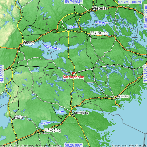
These maps also provides idea of topography and contour of this city, they are displayed at different zoom levels. More info about maps, scale and edge coordinates you can find below images.
| \ | Map #1 | Map #2 | Topo.Map |
| Scale [m] | 29..79 m | 26..83 m | × |
| Scale [ft] | 95..259 ft | 85..272 ft | × |
| Average | 50.8 m = 167 ft | 53.3 m = 175 ft | × |
| Width | 5.03 km = 3.1 mi | 10.07 km = 6.3 mi | 161.1 km = 100.1 mi |
| Height | 5.03 km = 3.1 mi | 10.07 km = 6.3 mi | 161.1 km = 100.1 mi |
| ↑Max Latitude | 59.018499° | 59.041113° | 59.71264° |
| Latitude at center | 58.99587° | 58.99587° | 58.99587° |
| ↓Min Latitude | 58.973226° | 58.950568° | 58.26386° |
| ← Min Longitude | 16.163265° | 16.119319° | 14.80096° |
| Longitude center | 16.20721° | 16.20721° | 16.20721° |
| →Max Longitude | 16.251155° | 16.295101° | 17.61346° |
Nearby cities:
Cities around Katrineholm sort by population:
• Åby elevation 27 m
36.6 km,  182°
182°
• Flen 37 m
22.9 km,  72°
72°
• Krokek 45 m
37.1 km,  165°
165°
• Vingåker 43 m
19.8 km,  285°
285°
• Svärtinge 92 m
39.3 km,  195°
195°
• Skogstorp 39 m
39.8 km,  23°
23°
• Malmköping 59 m
33.7 km,  63°
63°
• Stigtomta 46 m
39.6 km,  123°
123°
• Jursla 27 m
36.6 km, 182°
• Hälleforsnäs 79 m
24 km,  43°
43°
• Valla 30 m
10.3 km,  77°
77°
• Olstorp 21 m
31.6 km,  129°
129°
Multilingual:
 En español:
Katrineholm elevación 51 m.
 En France:
Katrineholm élévation 51 m.
 Auf Deutsch:
Katrineholm höhe über dem Meeresspiegel ist 51 m.

Sources and notes:
- [note 1] Map square and city borders are not equal. Map elevation data is calculated only from area inside that square.
- [src 1] Elevation data from geonames database provided with same terms of usage.
- [src 2] The elevation map of Katrineholm is generated using elevation data from NASA's 3 arcsec (90m) resolution SRTM data.
- [src 3] Base (background) map © OpenStreetMap contributors tiles are generated by Geofabrik and OpenTopoMap.
Copyright & License:
This Katrineholm Elevation Map is licensed under CC BY-SA. You may reuse any part from this page, if you give a proper credit by linking to this URL:
 More info on terms of use page.