Vingåker elevation
Vingåker (Södermanland, Vingåkers Kommun), Sweden elevation is 43 meters and Vingåker elevation in feet is 141 ft above sea level [src 1]. Vingåker is a seat of a second-order administrative division (feature code) with elevation that is 32 meters (105 ft) smaller than average city elevation in Sweden.
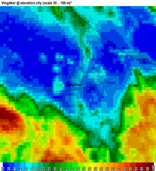
Below is the Elevation map of Vingåker, which displays elevation range with different colors. Scale of the first map is from 35 to 100 m (115 to 328 ft) with average elevation of 52.5 meters (=172 ft) [note 1]
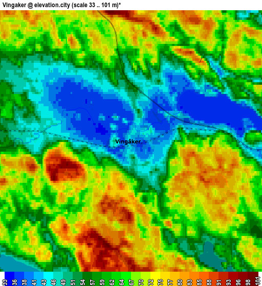
These maps also provides idea of topography and contour of this city, they are displayed at different zoom levels. More info about maps, scale and edge coordinates you can find below images.
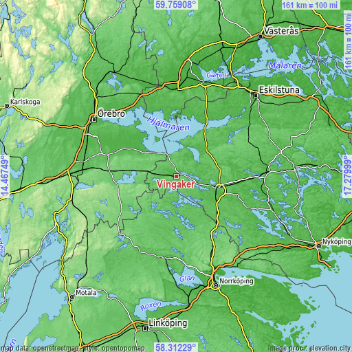
| \ | Map #1 | Map #2 | Topo.Map |
| Scale [m] | 35..100 m | 33..101 m | × |
| Scale [ft] | 115..328 ft | 108..331 ft | × |
| Average | 52.5 m = 172 ft | 62.2 m = 204 ft | × |
| Width | 5.03 km = 3.1 mi | 10.05 km = 6.2 mi | 160.9 km = 100 mi |
| Height | 5.03 km = 3.1 mi | 10.05 km = 6.2 mi | 160.8 km = 99.9 mi |
| ↑Max Latitude | 59.065898° | 59.08848° | 59.75908° |
| Latitude at center | 59.0433° | 59.0433° | 59.0433° |
| ↓Min Latitude | 59.020688° | 58.99806° | 58.31229° |
| ← Min Longitude | 15.829795° | 15.785849° | 14.46749° |
| Longitude center | 15.87374° | 15.87374° | 15.87374° |
| →Max Longitude | 15.917685° | 15.961631° | 17.27999° |
Nearby cities:
Cities around Vingåker sort by population:
• Katrineholm elevation 51 m
19.8 km,  105°
105°
• Kumla 57 m
42.8 km,  282°
282°
• Finspång 46 m
38 km,  189°
189°
• Arboga 18 m
39 km,  357°
357°
• Flen 37 m
40.9 km,  87°
87°
• Hällabrottet 60 m
39.3 km, 281°
• Hälleforsnäs 79 m
37.6 km,  71°
71°
• Pålsboda 94 m
30.8 km,  274°
274°
• Ekeby-Almby 45 m
39.3 km,  307°
307°
• Valla 30 m
29.3 km,  95°
95°
• Odensbacken 26 m
23.8 km, 305°
• Sköllersta 53 m
32.3 km,  288°
288°
Multilingual:
 En español:
Vingåker elevación 43 m.
 En France:
Vingåker élévation 43 m.


Sources and notes:
- [note 1] Map square and city borders are not equal. Map elevation data is calculated only from area inside that square.
- [src 1] Elevation data from geonames database provided with same terms of usage.
- [src 2] The elevation map of Vingåker is generated using elevation data from NASA's 3 arcsec (90m) resolution SRTM data.
- [src 3] Base (background) map © OpenStreetMap contributors tiles are generated by Geofabrik and OpenTopoMap.
Copyright & License:
This Vingåker Elevation Map is licensed under CC BY-SA. You may reuse any part from this page, if you give a proper credit by linking to this URL:
 More info on terms of use page.