Ljungsbro elevation
Ljungsbro (Östergötland, Linköpings Kommun), Sweden elevation is 68 meters and Ljungsbro elevation in feet is 223 ft above sea level [src 1]. Ljungsbro is a populated place (feature code) with elevation that is 7 meters (23 ft) smaller than average city elevation in Sweden.
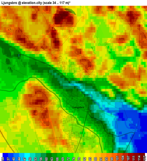
Below is the Elevation map of Ljungsbro, which displays elevation range with different colors. Scale of the first map is from 34 to 117 m (112 to 384 ft) with average elevation of 79.3 meters (=260 ft) [note 1]
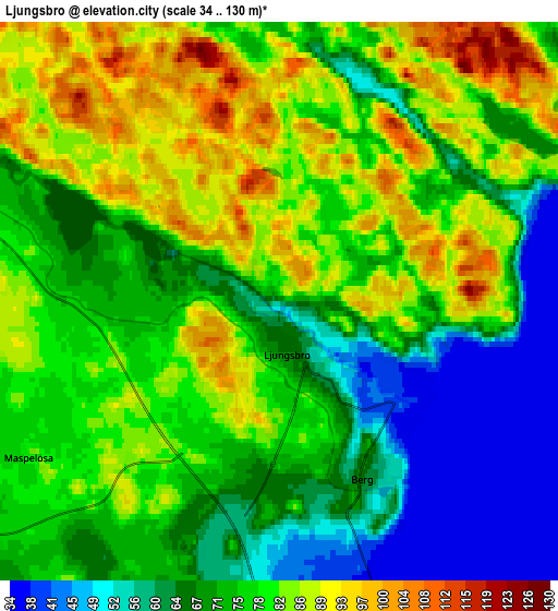
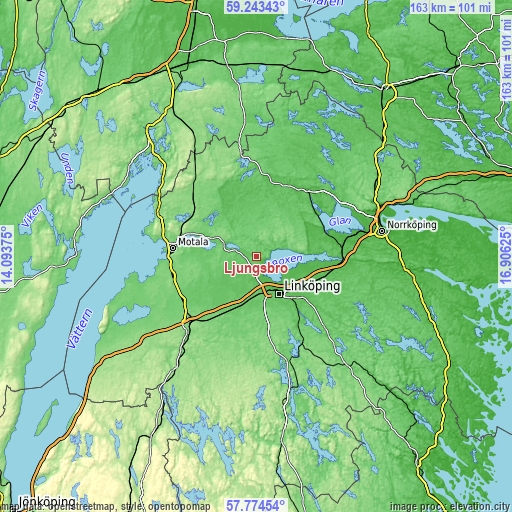
These maps also provides idea of topography and contour of this city, they are displayed at different zoom levels. More info about maps, scale and edge coordinates you can find below images.
| \ | Map #1 | Map #2 | Topo.Map |
| Scale [m] | 34..117 m | 34..130 m | × |
| Scale [ft] | 112..384 ft | 112..427 ft | × |
| Average | 79.3 m = 260 ft | 74.7 m = 245 ft | × |
| Width | 5.1 km = 3.2 mi | 10.21 km = 6.3 mi | 163.3 km = 101.5 mi |
| Height | 5.1 km = 3.2 mi | 10.21 km = 6.3 mi | 163.3 km = 101.5 mi |
| ↑Max Latitude | 58.539613° | 58.562541° | 59.24343° |
| Latitude at center | 58.51667° | 58.51667° | 58.51667° |
| ↓Min Latitude | 58.493712° | 58.470739° | 57.77454° |
| ← Min Longitude | 15.456055° | 15.412109° | 14.09375° |
| Longitude center | 15.5° | 15.5° | 15.5° |
| →Max Longitude | 15.543945° | 15.587891° | 16.90625° |
Nearby cities:
Cities around Ljungsbro sort by population:
• Linköping elevation 58 m
13.7 km,  148°
148°
• Malmslätt 88 m
11.8 km,  175°
175°
• Skärblacka 46 m
23.9 km,  76°
76°
• Mantorp 115 m
22.4 km,  214°
214°
• Tallboda 48 m
14.7 km,  133°
133°
• Borensberg 107 m
13.7 km,  293°
293°
• Linghem 56 m
18.9 km,  119°
119°
• Ekängen 40 m
9.5 km, 125°
• Vikingstad 86 m
15.4 km,  194°
194°
• Sturefors 72 m
24.5 km, 146°
• Stenstorp 119 m
25.4 km,  261°
261°
• Berg 60 m
3.6 km, 151°
Multilingual:
 En español:
Ljungsbro elevación 68 m.
 En France:
Ljungsbro élévation 68 m.
 Auf Deutsch:
Ljungsbro höhe über dem Meeresspiegel ist 68 m.

Sources and notes:
- [note 1] Map square and city borders are not equal. Map elevation data is calculated only from area inside that square.
- [src 1] Elevation data from geonames database provided with same terms of usage.
- [src 2] The elevation map of Ljungsbro is generated using elevation data from NASA's 3 arcsec (90m) resolution SRTM data.
- [src 3] Base (background) map © OpenStreetMap contributors tiles are generated by Geofabrik and OpenTopoMap.
Copyright & License:
This Ljungsbro Elevation Map is licensed under CC BY-SA. You may reuse any part from this page, if you give a proper credit by linking to this URL:
 More info on terms of use page.