Mantorp elevation
Mantorp (Östergötland, Mjölby Kommun), Sweden elevation is 115 meters and Mantorp elevation in feet is 377 ft above sea level [src 1]. Mantorp is a populated place (feature code) with elevation that is 40 meters (131 ft) bigger than average city elevation in Sweden.
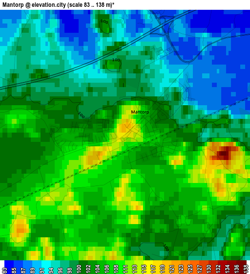
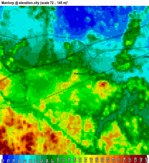
Below is the Elevation map of Mantorp, which displays elevation range with different colors. Scale of the first map is from 83 to 138 m (272 to 453 ft) with average elevation of 101 meters (=331 ft) [note 1]
These maps also provides idea of topography and contour of this city, they are displayed at different zoom levels. More info about maps, scale and edge coordinates you can find below images.
| \ | Map #1 | Map #2 | Topo.Map |
| Scale [m] | 83..138 m | 72..145 m | × |
| Scale [ft] | 272..453 ft | 236..476 ft | × |
| Average | 101 m = 331 ft | 99.6 m = 327 ft | × |
| Width | 5.13 km = 3.2 mi | 10.26 km = 6.4 mi | 164.1 km = 102 mi |
| Height | 5.13 km = 3.2 mi | 10.26 km = 6.4 mi | 164.1 km = 102 mi |
| ↑Max Latitude | 58.373052° | 58.396089° | 59.08023° |
| Latitude at center | 58.35° | 58.35° | 58.35° |
| ↓Min Latitude | 58.326933° | 58.303851° | 57.60436° |
| ← Min Longitude | 15.239385° | 15.195439° | 13.87708° |
| Longitude center | 15.28333° | 15.28333° | 15.28333° |
| →Max Longitude | 15.327275° | 15.371221° | 16.68958° |
Nearby cities:
Cities around Mantorp sort by population:
• Linköping elevation 58 m
20.8 km,  71°
71°
• Mjölby 121 m
9.7 km,  253°
253°
• Ljungsbro 68 m
22.4 km,  34°
34°
• Malmslätt 88 m
15.2 km,  63°
63°
• Skänninge 100 m
12.5 km,  293°
293°
• Tallboda 48 m
24.7 km, 70°
• Boxholm 147 m
21.7 km,  218°
218°
• Borensberg 107 m
24.1 km,  0°
0°
• Ekängen 40 m
24.2 km, 57°
• Vikingstad 86 m
9.4 km, 67°
• Stenstorp 119 m
19.5 km,  319°
319°
• Berg 60 m
21 km,  43°
43°
Multilingual:
 En español:
Mantorp elevación 115 m.
 En France:
Mantorp élévation 115 m.


Sources and notes:
- [note 1] Map square and city borders are not equal. Map elevation data is calculated only from area inside that square.
- [src 1] Elevation data from geonames database provided with same terms of usage.
- [src 2] The elevation map of Mantorp is generated using elevation data from NASA's 3 arcsec (90m) resolution SRTM data.
- [src 3] Base (background) map © OpenStreetMap contributors tiles are generated by Geofabrik and OpenTopoMap.
Copyright & License:
This Mantorp Elevation Map is licensed under CC BY-SA. You may reuse any part from this page, if you give a proper credit by linking to this URL:
 More info on terms of use page.