Malung elevation
Malung (Dalarna, Malung-Sälens kommun), Sweden elevation is 300 meters and Malung elevation in feet is 984 ft above sea level [src 1]. Malung is a seat of a second-order administrative division (feature code) with elevation that is 225 meters (738 ft) bigger than average city elevation in Sweden.
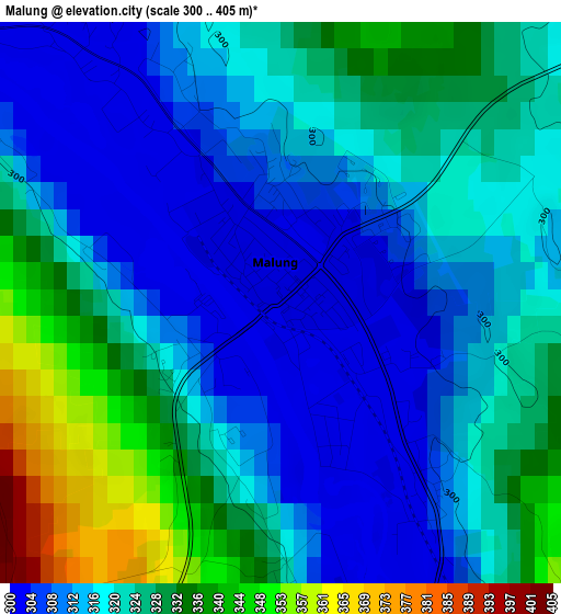
Below is the Elevation map of Malung, which displays elevation range with different colors. Scale of the first map is from 300 to 405 m (984 to 1329 ft) with average elevation of 320.6 meters (=1052 ft) [note 1]
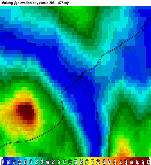
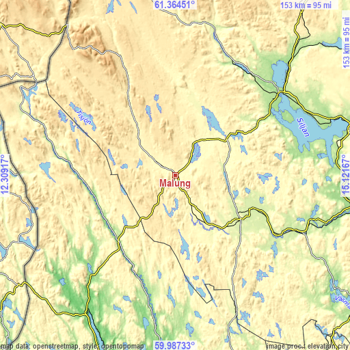
These maps also provides idea of topography and contour of this city, they are displayed at different zoom levels. More info about maps, scale and edge coordinates you can find below images.
| \ | Map #1 | Map #2 | Topo.Map |
| Scale [m] | 300..405 m | 296..475 m | × |
| Scale [ft] | 984..1329 ft | 971..1558 ft | × |
| Average | 320.6 m = 1052 ft | 340 m = 1115 ft | × |
| Width | 4.78 km = 3 mi | 9.57 km = 5.9 mi | 153.1 km = 95.1 mi |
| Height | 4.78 km = 3 mi | 9.57 km = 5.9 mi | 153.1 km = 95.1 mi |
| ↑Max Latitude | 60.7048° | 60.726296° | 61.36451° |
| Latitude at center | 60.68329° | 60.68329° | 60.68329° |
| ↓Min Latitude | 60.661766° | 60.640227° | 59.98733° |
| ← Min Longitude | 13.671475° | 13.627529° | 12.30917° |
| Longitude center | 13.71542° | 13.71542° | 13.71542° |
| →Max Longitude | 13.759365° | 13.803311° | 15.12167° |
Nearby cities:
Cities around Malung sort by population:
• Mora elevation 162 m
57.5 km,  51°
51°
• Leksand 163 m
70.1 km,  85°
85°
• Orsa 169 m
68.8 km, 45°
• Hagfors 150 m
73.4 km,  181°
181°
• Torsby 100 m
72.3 km,  212°
212°
• Smedby 177 m
72.7 km, 88°
• Vansbro 250 m
33.9 km,  124°
124°
• Mockfjärd 177 m
71.3 km,  106°
106°
• Älvdalen 253 m
63 km,  16°
16°
• Järna 234 m
39.3 km, 115°
• Siljansnäs 221 m
62.7 km,  79°
79°
• Ekshärad 150 m
58 km,  191°
191°
Multilingual:
 En español:
Malung elevación 300 m.
 En France:
Malung élévation 300 m.


Sources and notes:
- [note 1] Map square and city borders are not equal. Map elevation data is calculated only from area inside that square.
- [src 1] Elevation data from geonames database provided with same terms of usage.
- [src 2] The elevation map of Malung is generated using GMTED2010 database with 7.5 arcsec (225m) resolution.
- [src 3] Base (background) map © OpenStreetMap contributors tiles are generated by Geofabrik and OpenTopoMap.
Copyright & License:
This Malung Elevation Map is licensed under CC BY-SA. You may reuse any part from this page, if you give a proper credit by linking to this URL:
 More info on terms of use page.