Orsa elevation
Orsa (Dalarna, Orsa Kommun), Sweden elevation is 169 meters and Orsa elevation in feet is 554 ft above sea level [src 1]. Orsa is a seat of a second-order administrative division (feature code) with elevation that is 94 meters (308 ft) bigger than average city elevation in Sweden.
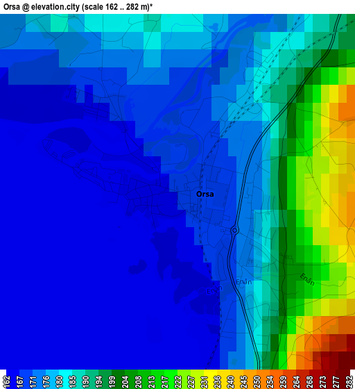
Below is the Elevation map of Orsa, which displays elevation range with different colors. Scale of the first map is from 162 to 282 m (531 to 925 ft) with average elevation of 179.9 meters (=590 ft) [note 1]
These maps also provides idea of topography and contour of this city, they are displayed at different zoom levels. More info about maps, scale and edge coordinates you can find below images.
| \ | Map #1 | Map #2 | Topo.Map |
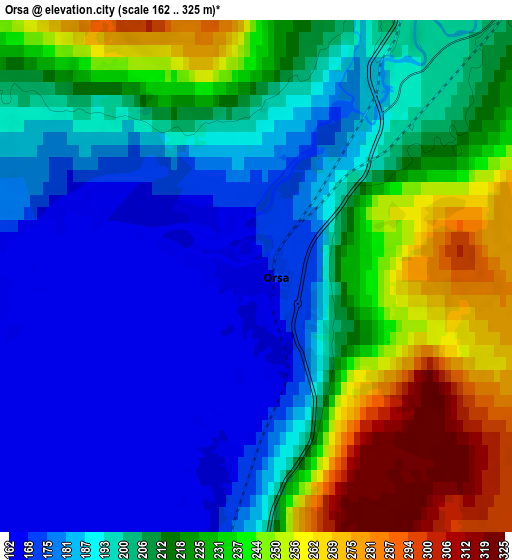
| Scale [m] | 162..282 m | 162..325 m | × |
| Scale [ft] | 531..925 ft | 531..1066 ft | × |
| Average | 179.9 m = 590 ft | 208.3 m = 683 ft | × |
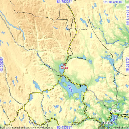
| Width | 4.72 km = 2.9 mi | 9.44 km = 5.9 mi | 151 km = 93.8 mi |
| Height | 4.72 km = 2.9 mi | 9.44 km = 5.9 mi | 151 km = 93.8 mi |
| ↑Max Latitude | 61.141557° | 61.16276° | 61.79226° |
| Latitude at center | 61.12034° | 61.12034° | 61.12034° |
| ↓Min Latitude | 61.099109° | 61.077863° | 60.43383° |
| ← Min Longitude | 14.571555° | 14.527609° | 13.20925° |
| Longitude center | 14.6155° | 14.6155° | 14.6155° |
| →Max Longitude | 14.659445° | 14.703391° | 16.02175° |
Nearby cities:
Cities around Orsa sort by population:
• Mora elevation 162 m
13.2 km,  197°
197°
• Leksand 163 m
48.1 km,  154°
154°
• Rättvik 174 m
37.6 km,  133°
133°
• Smedby 177 m
52.3 km, 153°
• Insjön 200 m
55.7 km, 152°
• Bjursås 177 m
62.1 km, 133°
• Grycksbo 159 m
67.3 km,  135°
135°
• Älvdalen 253 m
33.1 km,  291°
291°
• Järna 234 m
66.6 km,  191°
191°
• Siljansnäs 221 m
39.6 km,  161°
161°
• Gagnef 172 m
63.2 km, 156°
• Vikarbyn 215 m
31.3 km, 136°
Multilingual:
 En español:
Orsa elevación 169 m.
 En France:
Orsa élévation 169 m.


Sources and notes:
- [note 1] Map square and city borders are not equal. Map elevation data is calculated only from area inside that square.
- [src 1] Elevation data from geonames database provided with same terms of usage.
- [src 2] The elevation map of Orsa is generated using GMTED2010 database with 7.5 arcsec (225m) resolution.
- [src 3] Base (background) map © OpenStreetMap contributors tiles are generated by Geofabrik and OpenTopoMap.
Copyright & License:
This Orsa Elevation Map is licensed under CC BY-SA. You may reuse any part from this page, if you give a proper credit by linking to this URL:
 More info on terms of use page.