Södra Vi elevation
Södra Vi (Kalmar, Vimmerby Kommun), Sweden elevation is 125 meters and Södra Vi elevation in feet is 410 ft above sea level [src 1]. Södra Vi is a populated place (feature code) with elevation that is 50 meters (164 ft) bigger than average city elevation in Sweden.
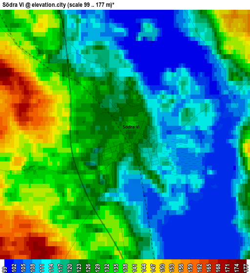
Below is the Elevation map of Södra Vi, which displays elevation range with different colors. Scale of the first map is from 99 to 177 m (325 to 581 ft) with average elevation of 123.6 meters (=406 ft) [note 1]
These maps also provides idea of topography and contour of this city, they are displayed at different zoom levels. More info about maps, scale and edge coordinates you can find below images.
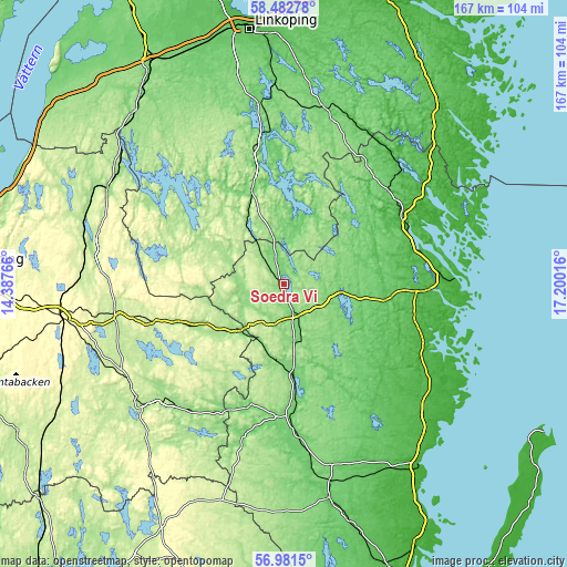
| \ | Map #1 | Topo.Map |
| Scale [m] | 99..177 m | × |
| Scale [ft] | 325..581 ft | × |
| Average | 123.6 m = 406 ft | × |
| Width | 5.22 km = 3.2 mi | 166.9 km = 103.7 mi |
| Height | 5.22 km = 3.2 mi | 166.9 km = 103.7 mi |
| ↑Max Latitude | 57.763379° | 58.48278° |
| Latitude at center | 57.73993° | 57.73993° |
| ↓Min Latitude | 57.716466° | 56.9815° |
| ← Min Longitude | 15.749965° | 14.38766° |
| Longitude center | 15.79391° | 15.79391° |
| →Max Longitude | 15.837855° | 17.20016° |
Nearby cities:
Cities around Södra Vi sort by population:
• Vimmerby elevation 124 m
9 km,  156°
156°
• Hultsfred 104 m
28.2 km,  173°
173°
• Kisa 108 m
29.2 km,  340°
340°
• Gamleby 32 m
40.1 km,  64°
64°
• Rimforsa 95 m
44.5 km,  351°
351°
• Mariannelund 147 m
19.2 km,  224°
224°
• Målilla 97 m
39.2 km,  178°
178°
• Ankarsrum 57 m
32.4 km,  98°
98°
• Överum 64 m
41.4 km,  48°
48°
• Gunnebo 31 m
44 km,  93°
93°
• Storebro 111 m
17.7 km, 169°
• Österbymo 188 m
32.3 km,  286°
286°
Multilingual:
 En español:
Södra Vi elevación 125 m.
 En France:
Södra Vi élévation 125 m.
 Auf Deutsch:
Södra Vi höhe über dem Meeresspiegel ist 125 m.

Sources and notes:
- [note 1] Map square and city borders are not equal. Map elevation data is calculated only from area inside that square.
- [src 1] Elevation data from geonames database provided with same terms of usage.
- [src 2] The elevation map of Södra Vi is generated using elevation data from NASA's 3 arcsec (90m) resolution SRTM data.
- [src 3] Base (background) map © OpenStreetMap contributors tiles are generated by Geofabrik and OpenTopoMap.
Copyright & License:
This Södra Vi Elevation Map is licensed under CC BY-SA. You may reuse any part from this page, if you give a proper credit by linking to this URL:
 More info on terms of use page.