Storå elevation
Storå (Örebro, Lindesbergs Kommun), Sweden elevation is 71 meters and Storå elevation in feet is 233 ft above sea level [src 1]. Storå is a populated place (feature code) with elevation that is 4 meters (13 ft) smaller than average city elevation in Sweden.
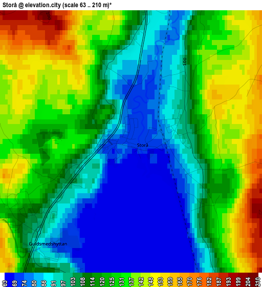
Below is the Elevation map of Storå, which displays elevation range with different colors. Scale of the first map is from 63 to 210 m (207 to 689 ft) with average elevation of 114.7 meters (=376 ft) [note 1]
These maps also provides idea of topography and contour of this city, they are displayed at different zoom levels. More info about maps, scale and edge coordinates you can find below images.
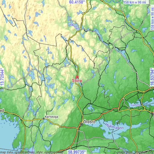
| \ | Map #1 | Topo.Map |
| Scale [m] | 63..210 m | × |
| Scale [ft] | 207..689 ft | × |
| Average | 114.7 m = 376 ft | × |
| Width | 4.93 km = 3.1 mi | 157.7 km = 98 mi |
| Height | 4.93 km = 3.1 mi | 157.7 km = 98 mi |
| ↑Max Latitude | 59.736245° | 60.4158° |
| Latitude at center | 59.71409° | 59.71409° |
| ↓Min Latitude | 59.69192° | 58.99735° |
| ← Min Longitude | 15.087745° | 13.72544° |
| Longitude center | 15.13169° | 15.13169° |
| →Max Longitude | 15.175635° | 16.53794° |
Nearby cities:
Cities around Storå sort by population:
• Ludvika elevation 143 m
48.5 km,  3°
3°
• Lindesberg 74 m
14.7 km,  157°
157°
• Nora 104 m
22.3 km,  193°
193°
• Hällefors 201 m
35 km,  282°
282°
• Kopparberg 167 m
19.6 km,  336°
336°
• Hovsta 39 m
40.8 km,  173°
173°
• Frövi 45 m
30.5 km,  154°
154°
• Kolsva 47 m
41.4 km,  107°
107°
• Skinnskatteberg 120 m
34 km,  67°
67°
• Grängesberg 305 m
40.7 km,  350°
350°
• Garphyttan 99 m
46.8 km, 192°
• Fellingsbro 26 m
40.3 km,  140°
140°
Multilingual:
 En español:
Storå elevación 71 m.
 En France:
Storå élévation 71 m.


Sources and notes:
- [note 1] Map square and city borders are not equal. Map elevation data is calculated only from area inside that square.
- [src 1] Elevation data from geonames database provided with same terms of usage.
- [src 2] The elevation map of Storå is generated using elevation data from NASA's 3 arcsec (90m) resolution SRTM data.
- [src 3] Base (background) map © OpenStreetMap contributors tiles are generated by Geofabrik and OpenTopoMap.
Copyright & License:
This Storå Elevation Map is licensed under CC BY-SA. You may reuse any part from this page, if you give a proper credit by linking to this URL:
 More info on terms of use page.