Sveg elevation
Sveg (Jämtland, Härjedalens kommun), Sweden elevation is 354 meters and Sveg elevation in feet is 1161 ft above sea level [src 1]. Sveg is a seat of a second-order administrative division (feature code) with elevation that is 279 meters (915 ft) bigger than average city elevation in Sweden.
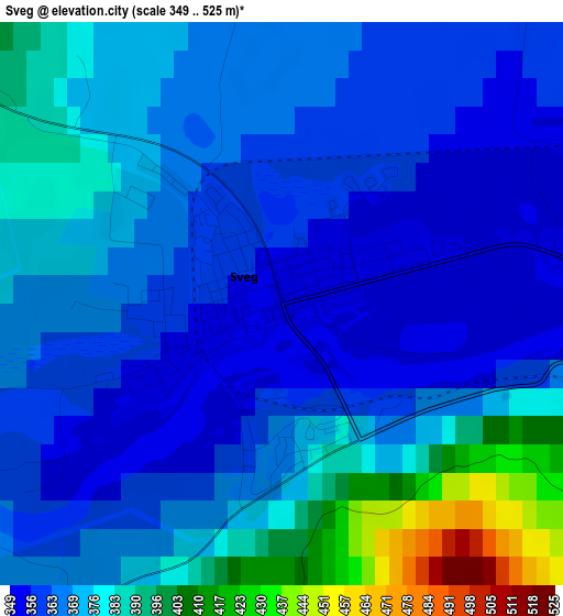
Below is the Elevation map of Sveg, which displays elevation range with different colors. Scale of the first map is from 349 to 525 m (1145 to 1722 ft) with average elevation of 371.6 meters (=1219 ft) [note 1]
These maps also provides idea of topography and contour of this city, they are displayed at different zoom levels. More info about maps, scale and edge coordinates you can find below images.
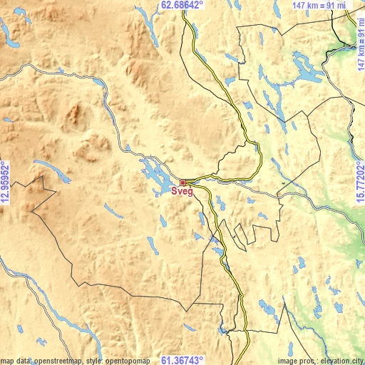
| \ | Map #1 | Topo.Map |
| Scale [m] | 349..525 m | × |
| Scale [ft] | 1145..1722 ft | × |
| Average | 371.6 m = 1219 ft | × |
| Width | 4.58 km = 2.8 mi | 146.7 km = 91.2 mi |
| Height | 4.58 km = 2.8 mi | 146.6 km = 91.1 mi |
| ↑Max Latitude | 62.054671° | 62.68642° |
| Latitude at center | 62.03407° | 62.03407° |
| ↓Min Latitude | 62.013455° | 61.36743° |
| ← Min Longitude | 14.321825° | 12.95952° |
| Longitude center | 14.36577° | 14.36577° |
| →Max Longitude | 14.409715° | 15.77202° |
Nearby cities:
Cities around Sveg sort by population:
• Mora elevation 162 m
114.6 km,  175°
175°
• Ljusdal 132 m
93.1 km,  104°
104°
• Orsa 169 m
102.5 km,  172°
172°
• Edsbyn 155 m
105.8 km,  133°
133°
• Ånge 168 m
86.3 km,  50°
50°
• Delsbo 62 m
117.5 km, 102°
• Fränsta 74 m
106.7 km,  61°
61°
• Älvdalen 253 m
91.3 km,  190°
190°
• Bräcke 307 m
96.5 km,  34°
34°
• Järvsö 111 m
100.8 km,  110°
110°
• Färila 156 m
81.6 km, 108°
• Hoverberg 300 m
86.8 km,  2°
2°
Multilingual:
 En español:
Sveg elevación 354 m.
 En France:
Sveg élévation 354 m.


Sources and notes:
- [note 1] Map square and city borders are not equal. Map elevation data is calculated only from area inside that square.
- [src 1] Elevation data from geonames database provided with same terms of usage.
- [src 2] The elevation map of Sveg is generated using GMTED2010 database with 7.5 arcsec (225m) resolution.
- [src 3] Base (background) map © OpenStreetMap contributors tiles are generated by Geofabrik and OpenTopoMap.
Copyright & License:
This Sveg Elevation Map is licensed under CC BY-SA. You may reuse any part from this page, if you give a proper credit by linking to this URL:
 More info on terms of use page.