Vilhelmina elevation
Vilhelmina (Västerbotten, Vilhelmina Kommun), Sweden elevation is 349 meters and Vilhelmina elevation in feet is 1145 ft above sea level [src 1]. Vilhelmina is a seat of a second-order administrative division (feature code) with elevation that is 274 meters (899 ft) bigger than average city elevation in Sweden.
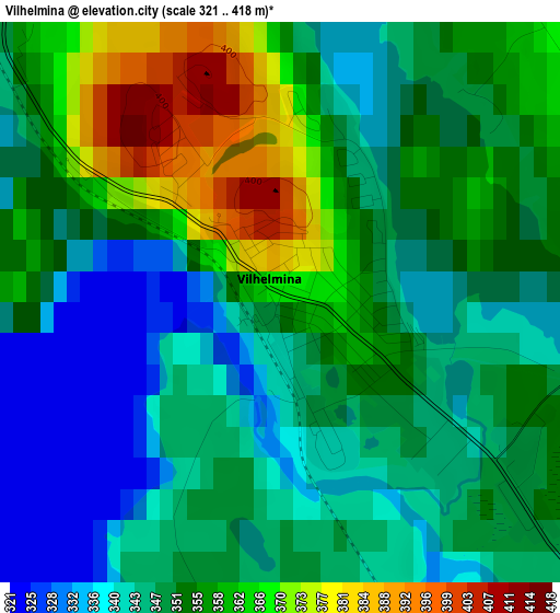
Below is the Elevation map of Vilhelmina, which displays elevation range with different colors. Scale of the first map is from 321 to 418 m (1053 to 1371 ft) with average elevation of 352 meters (=1155 ft) [note 1]
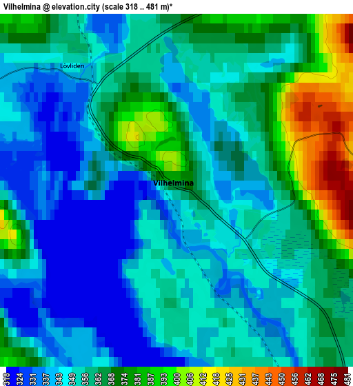
These maps also provides idea of topography and contour of this city, they are displayed at different zoom levels. More info about maps, scale and edge coordinates you can find below images.
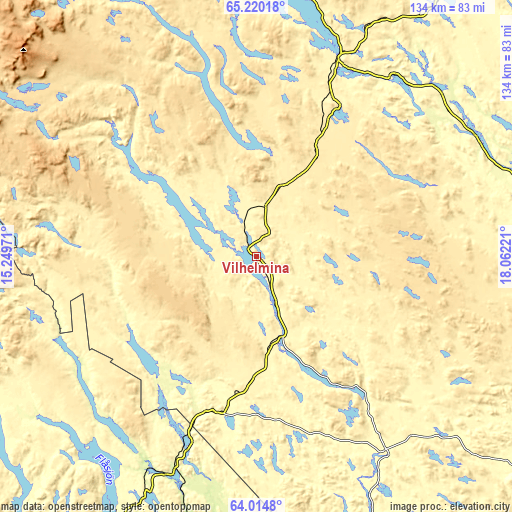
| \ | Map #1 | Map #2 | Topo.Map |
| Scale [m] | 321..418 m | 318..481 m | × |
| Scale [ft] | 1053..1371 ft | 1043..1578 ft | × |
| Average | 352 m = 1155 ft | 357.3 m = 1172 ft | × |
| Width | 4.19 km = 2.6 mi | 8.38 km = 5.2 mi | 134 km = 83.3 mi |
| Height | 4.19 km = 2.6 mi | 8.38 km = 5.2 mi | 134 km = 83.3 mi |
| ↑Max Latitude | 64.642996° | 64.66181° | 65.22018° |
| Latitude at center | 64.62417° | 64.62417° | 64.62417° |
| ↓Min Latitude | 64.605331° | 64.586478° | 64.0148° |
| ← Min Longitude | 16.612015° | 16.568069° | 15.24971° |
| Longitude center | 16.65596° | 16.65596° | 16.65596° |
| →Max Longitude | 16.699905° | 16.743851° | 18.06221° |
Nearby cities:
Cities around Vilhelmina sort by population:
• Lycksele elevation 224 m
96.2 km,  91°
91°
• Strömsund 299 m
101 km,  211°
211°
• Storuman 396 m
56.8 km,  22°
22°
• Insjön 422 m
46.8 km,  122°
122°
• Norsjö 300 m
137.7 km,  76°
76°
• Malå 324 m
116.5 km,  57°
57°
• Åsele 320 m
61.4 km,  147°
147°
• Söderfors 273 m
69.6 km,  72°
72°
• Dorotea 336 m
41.9 km,  196°
196°
• Sorsele 340 m
109.3 km, 22°
• Ås 179 m
139.9 km,  181°
181°
• Hammerdal 290 m
132.3 km, 208°
Multilingual:
 En español:
Vilhelmina elevación 349 m.
 En France:
Vilhelmina élévation 349 m.
 Auf Deutsch:
Vilhelmina höhe über dem Meeresspiegel ist 349 m.

Sources and notes:
- [note 1] Map square and city borders are not equal. Map elevation data is calculated only from area inside that square.
- [src 1] Elevation data from geonames database provided with same terms of usage.
- [src 2] The elevation map of Vilhelmina is generated using GMTED2010 database with 7.5 arcsec (225m) resolution.
- [src 3] Base (background) map © OpenStreetMap contributors tiles are generated by Geofabrik and OpenTopoMap.
Copyright & License:
This Vilhelmina Elevation Map is licensed under CC BY-SA. You may reuse any part from this page, if you give a proper credit by linking to this URL:
 More info on terms of use page.