Vinninga elevation
Vinninga (Västra Götaland, Lidköpings Kommun), Sweden elevation is 78 meters and Vinninga elevation in feet is 256 ft above sea level [src 1]. Vinninga is a populated place (feature code) with elevation that is 3 meters (10 ft) bigger than average city elevation in Sweden.
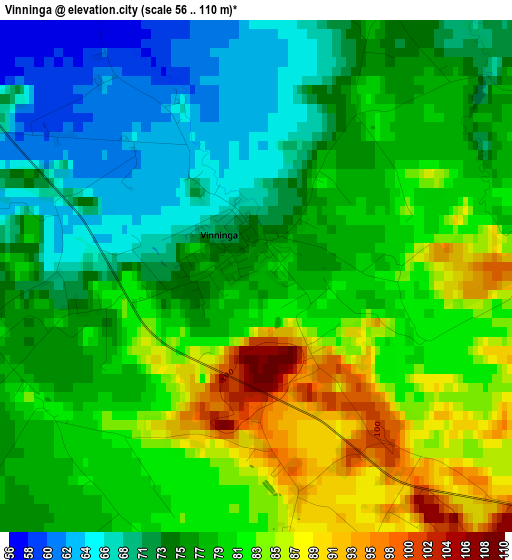
Below is the Elevation map of Vinninga, which displays elevation range with different colors. Scale of the first map is from 56 to 110 m (184 to 361 ft) with average elevation of 77.7 meters (=255 ft) [note 1]
These maps also provides idea of topography and contour of this city, they are displayed at different zoom levels. More info about maps, scale and edge coordinates you can find below images.
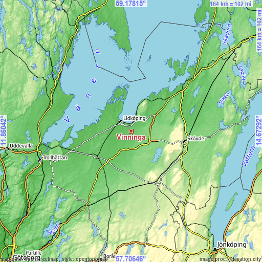
| \ | Map #1 | Topo.Map |
| Scale [m] | 56..110 m | × |
| Scale [ft] | 184..361 ft | × |
| Average | 77.7 m = 255 ft | × |
| Width | 5.11 km = 3.2 mi | 163.6 km = 101.7 mi |
| Height | 5.11 km = 3.2 mi | 163.6 km = 101.7 mi |
| ↑Max Latitude | 58.472987° | 59.17815° |
| Latitude at center | 58.45° | 58.45° |
| ↓Min Latitude | 58.426998° | 57.70646° |
| ← Min Longitude | 13.222725° | 11.86042° |
| Longitude center | 13.26667° | 13.26667° |
| →Max Longitude | 13.310615° | 14.67292° |
Nearby cities:
Cities around Vinninga sort by population:
• Skövde elevation 152 m
34.3 km,  100°
100°
• Lidköping 52 m
8.8 km,  314°
314°
• Falköping 217 m
34.9 km,  151°
151°
• Skara 120 m
12.2 km,  125°
125°
• Åkarp 161 m
32.9 km,  137°
137°
• Götene 79 m
15.8 km,  56°
56°
• Vara 84 m
27.7 km,  221°
221°
• Skultorp 150 m
34.8 km,  108°
108°
• Stenstorp 175 m
32.7 km, 127°
• Källby 59 m
7 km,  18°
18°
• Kvänum 81 m
17.4 km,  196°
196°
• Axvall 129 m
19 km, 112°
Multilingual:
 En español:
Vinninga elevación 78 m.
 En France:
Vinninga élévation 78 m.


Sources and notes:
- [note 1] Map square and city borders are not equal. Map elevation data is calculated only from area inside that square.
- [src 1] Elevation data from geonames database provided with same terms of usage.
- [src 2] The elevation map of Vinninga is generated using elevation data from NASA's 3 arcsec (90m) resolution SRTM data.
- [src 3] Base (background) map © OpenStreetMap contributors tiles are generated by Geofabrik and OpenTopoMap.
Copyright & License:
This Vinninga Elevation Map is licensed under CC BY-SA. You may reuse any part from this page, if you give a proper credit by linking to this URL:
 More info on terms of use page.