Vrigstad elevation
Vrigstad (Jönköping, Sävsjö Kommun), Sweden elevation is 192 meters and Vrigstad elevation in feet is 630 ft above sea level [src 1]. Vrigstad is a populated place (feature code) with elevation that is 117 meters (384 ft) bigger than average city elevation in Sweden.
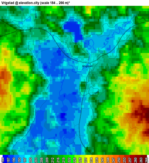
Below is the Elevation map of Vrigstad, which displays elevation range with different colors. Scale of the first map is from 184 to 266 m (604 to 873 ft) with average elevation of 210.4 meters (=690 ft) [note 1]
These maps also provides idea of topography and contour of this city, they are displayed at different zoom levels. More info about maps, scale and edge coordinates you can find below images.
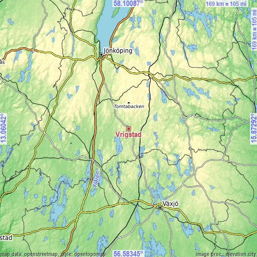
| \ | Map #1 | Topo.Map |
| Scale [m] | 184..266 m | × |
| Scale [ft] | 604..873 ft | × |
| Average | 210.4 m = 690 ft | × |
| Width | 5.27 km = 3.3 mi | 168.7 km = 104.8 mi |
| Height | 5.27 km = 3.3 mi | 168.7 km = 104.8 mi |
| ↑Max Latitude | 57.373701° | 58.10087° |
| Latitude at center | 57.35° | 57.35° |
| ↓Min Latitude | 57.326284° | 56.58345° |
| ← Min Longitude | 14.422725° | 13.06042° |
| Longitude center | 14.46667° | 14.46667° |
| →Max Longitude | 14.510615° | 15.87292° |
Nearby cities:
Cities around Vrigstad sort by population:
• Värnamo elevation 156 m
31.5 km,  234°
234°
• Nässjö 303 m
36.4 km,  22°
22°
• Sävsjö 226 m
13.1 km,  63°
63°
• Vaggeryd 203 m
25.2 km,  310°
310°
• Skillingaryd 188 m
24.1 km,  291°
291°
• Bodafors 276 m
21.8 km,  39°
39°
• Hillerstorp 166 m
35.2 km,  263°
263°
• Lammhult 210 m
21.6 km,  161°
161°
• Landsbro 205 m
26.1 km,  85°
85°
• Bor 169 m
31.6 km,  214°
214°
• Malmbäck 285 m
25.2 km,  359°
359°
• Stockaryd 226 m
8.4 km,  115°
115°
Multilingual:
 En español:
Vrigstad elevación 192 m.
 En France:
Vrigstad élévation 192 m.
 Auf Deutsch:
Vrigstad höhe über dem Meeresspiegel ist 192 m.

Sources and notes:
- [note 1] Map square and city borders are not equal. Map elevation data is calculated only from area inside that square.
- [src 1] Elevation data from geonames database provided with same terms of usage.
- [src 2] The elevation map of Vrigstad is generated using elevation data from NASA's 3 arcsec (90m) resolution SRTM data.
- [src 3] Base (background) map © OpenStreetMap contributors tiles are generated by Geofabrik and OpenTopoMap.
Copyright & License:
This Vrigstad Elevation Map is licensed under CC BY-SA. You may reuse any part from this page, if you give a proper credit by linking to this URL:
 More info on terms of use page.