Tumayr elevation
Tumayr (Ar Riyāḑ), Saudi Arabia elevation is 648 meters and Tumayr elevation in feet is 2126 ft above sea level [src 1]. Tumayr is a populated place (feature code) with elevation that is 128 meters (420 ft) bigger than average city elevation in Saudi Arabia.
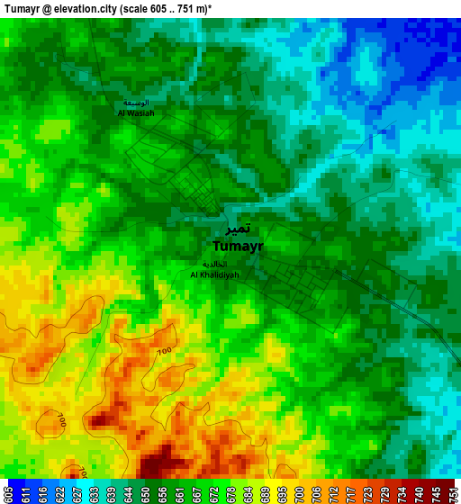
Below is the Elevation map of Tumayr, which displays elevation range with different colors. Scale of the first map is from 605 to 751 m (1985 to 2464 ft) with average elevation of 662.8 meters (=2175 ft) [note 1]
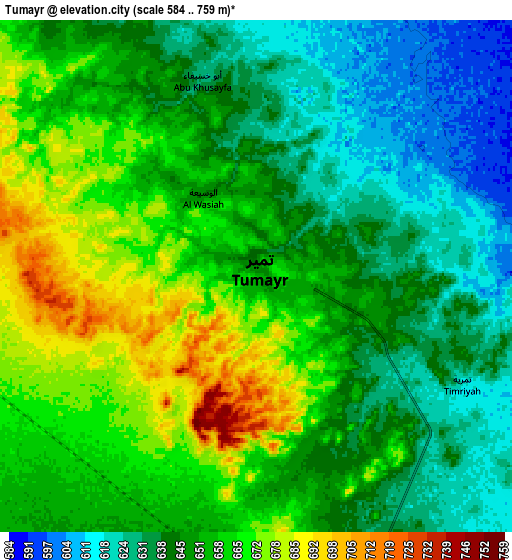
These maps also provides idea of topography and contour of this city, they are displayed at different zoom levels. More info about maps, scale and edge coordinates you can find below images.
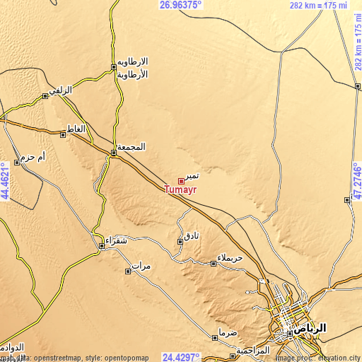
| \ | Map #1 | Map #2 | Topo.Map |
| Scale [m] | 605..751 m | 584..759 m | × |
| Scale [ft] | 1985..2464 ft | 1916..2490 ft | × |
| Average | 662.8 m = 2175 ft | 650.3 m = 2134 ft | × |
| Width | 8.81 km = 5.5 mi | 17.61 km = 10.9 mi | 281.8 km = 175.1 mi |
| Height | 8.81 km = 5.5 mi | 17.61 km = 10.9 mi | 281.8 km = 175.1 mi |
| ↑Max Latitude | 25.74306° | 25.782638° | 26.96375° |
| Latitude at center | 25.70347° | 25.70347° | 25.70347° |
| ↓Min Latitude | 25.663866° | 25.62425° | 24.4297° |
| ← Min Longitude | 45.824405° | 45.780459° | 44.4621° |
| Longitude center | 45.86835° | 45.86835° | 45.86835° |
| →Max Longitude | 45.912295° | 45.956241° | 47.2746° |
Nearby cities:
Cities around Tumayr sort by population:
• Riyadh elevation 612 m
141.9 km,  142°
142°
• Buraydah 606 m
201.5 km,  290°
290°
• Al Mithnab 632 m
165.7 km,  276°
276°
• Ad Dawādimī 975 m
199.4 km,  228°
228°
• Az Zulfī 620 m
124.4 km,  302°
302°
• Al Bukayrīyah 668 m
226.3 km, 282°
• Sājir 732 m
139.9 km,  245°
245°
• Al Arţāwīyah 614 m
103 km,  329°
329°
• Marāt 692 m
81.6 km,  210°
210°
• shokhaibٍ 621 m
140.8 km,  163°
163°
• Unaizah 654 m
195.2 km, 282°
• Al Majma‘ah 712 m
56.2 km, 294°
Multilingual:
 En español:
Tumayr elevación 648 m.
 En France:
Tumayr élévation 648 m.


Sources and notes:
- [note 1] Map square and city borders are not equal. Map elevation data is calculated only from area inside that square.
- [src 1] Elevation data from geonames database provided with same terms of usage.
- [src 2] The elevation map of Tumayr is generated using elevation data from NASA's 3 arcsec (90m) resolution SRTM data.
- [src 3] Base (background) map © OpenStreetMap contributors tiles are generated by Geofabrik and OpenTopoMap.
Copyright & License:
This Tumayr Elevation Map is licensed under CC BY-SA. You may reuse any part from this page, if you give a proper credit by linking to this URL:
 More info on terms of use page.