Ha'il elevation
Ha'il (Ḩāʼil), Saudi Arabia elevation is 1002 meters and Ha'il elevation in feet is 3287 ft above sea level [src 1]. Ha'il is a seat of a first-order administrative division (feature code) with elevation that is 482 meters (1581 ft) bigger than average city elevation in Saudi Arabia.
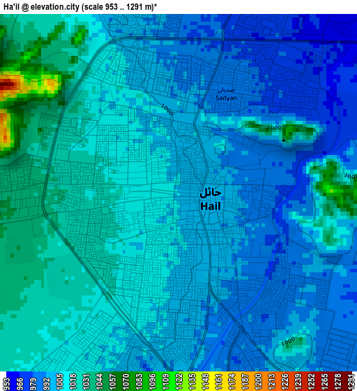
Below is the Elevation map of Ha'il, which displays elevation range with different colors. Scale of the first map is from 953 to 1291 m (3127 to 4236 ft) with average elevation of 1006.2 meters (=3301 ft) [note 1]
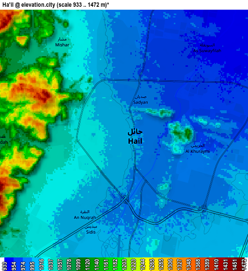
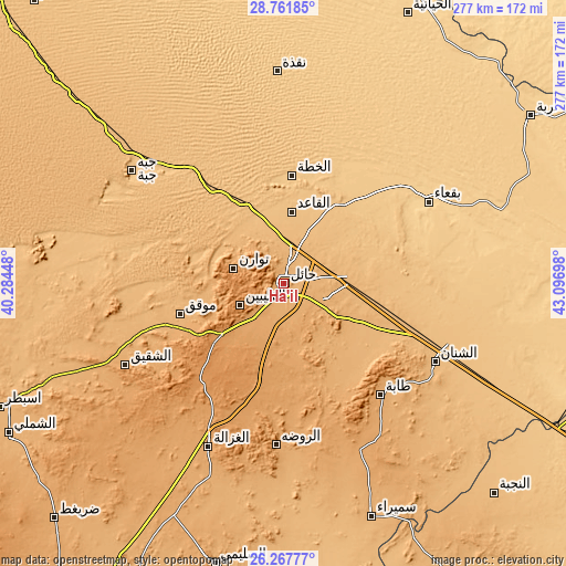
These maps also provides idea of topography and contour of this city, they are displayed at different zoom levels. More info about maps, scale and edge coordinates you can find below images.
| \ | Map #1 | Map #2 | Topo.Map |
| Scale [m] | 953..1291 m | 933..1472 m | × |
| Scale [ft] | 3127..4236 ft | 3061..4829 ft | × |
| Average | 1006.2 m = 3301 ft | 1028.8 m = 3375 ft | × |
| Width | 8.67 km = 5.4 mi | 17.33 km = 10.8 mi | 277.3 km = 172.3 mi |
| Height | 8.67 km = 5.4 mi | 17.33 km = 10.8 mi | 277.3 km = 172.3 mi |
| ↑Max Latitude | 27.560845° | 27.599797° | 28.76185° |
| Latitude at center | 27.52188° | 27.52188° | 27.52188° |
| ↓Min Latitude | 27.482901° | 27.443908° | 26.26777° |
| ← Min Longitude | 41.646785° | 41.602839° | 40.28448° |
| Longitude center | 41.69073° | 41.69073° | 41.69073° |
| →Max Longitude | 41.734675° | 41.778621° | 43.09698° |
Nearby cities:
Cities around Ha'il sort by population:
• Buraydah elevation 606 m
262.6 km,  120°
120°
• Sakakah 555 m
308.2 km,  332°
332°
• Ar Rass 691 m
256.8 km,  135°
135°
• Al Mithnab 632 m
312.1 km,  126°
126°
• Az Zulfī 620 m
338.3 km,  113°
113°
• Al Bukayrīyah 668 m
248.4 km, 128°
• Adh Dhibiyah 740 m
220.9 km, 138°
• Tanūmah 587 m
245.8 km,  101°
101°
• Şuwayr 592 m
315.2 km,  336°
336°
• Al Fuwayliq 755 m
195.7 km, 127°
• Wed Alnkil 812 m
259.3 km,  153°
153°
• Unaizah 654 m
276.2 km, 125°
Multilingual:
 En español:
Ha'il elevación 1002 m.
 En France:
Ha'il élévation 1002 m.


Sources and notes:
- [note 1] Map square and city borders are not equal. Map elevation data is calculated only from area inside that square.
- [src 1] Elevation data from geonames database provided with same terms of usage.
- [src 2] The elevation map of Ha'il is generated using elevation data from NASA's 3 arcsec (90m) resolution SRTM data.
- [src 3] Base (background) map © OpenStreetMap contributors tiles are generated by Geofabrik and OpenTopoMap.
Copyright & License:
This Ha'il Elevation Map is licensed under CC BY-SA. You may reuse any part from this page, if you give a proper credit by linking to this URL:
 More info on terms of use page.