Nzega elevation
Nzega (Southern Province, Nyamagabe District), Rwanda elevation is 1993 meters and Nzega elevation in feet is 6539 ft above sea level [src 1]. Nzega is a populated place (feature code) with elevation that is 256 meters (840 ft) bigger than average city elevation in Rwanda.
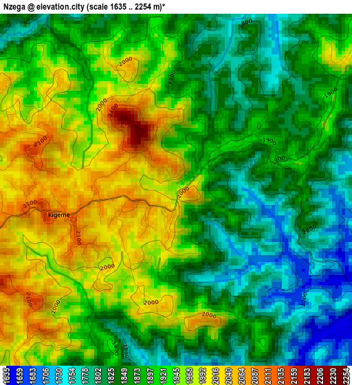
Below is the Elevation map of Nzega, which displays elevation range with different colors. Scale of the first map is from 1635 to 2254 m (5364 to 7395 ft) with average elevation of 1901.6 meters (=6239 ft) [note 1]
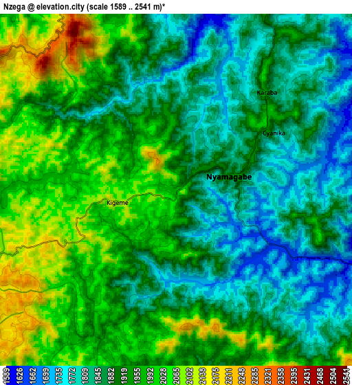
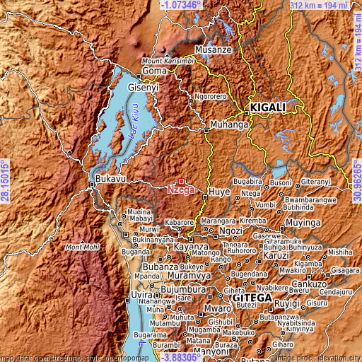
These maps also provides idea of topography and contour of this city, they are displayed at different zoom levels. More info about maps, scale and edge coordinates you can find below images.
| \ | Map #1 | Map #2 | Topo.Map |
| Scale [m] | 1635..2254 m | 1589..2541 m | × |
| Scale [ft] | 5364..7395 ft | 5213..8337 ft | × |
| Average | 1901.6 m = 6239 ft | 1917.9 m = 6292 ft | × |
| Width | 9.76 km = 6.1 mi | 19.53 km = 12.1 mi | 312.4 km = 194.1 mi |
| Height | 9.76 km = 6.1 mi | 19.53 km = 12.1 mi | 312.4 km = 194.1 mi |
| ↑Max Latitude | -2.435095° | -2.391189° | -1.07346° |
| Latitude at center | -2.479° | -2.479° | -2.479° |
| ↓Min Latitude | -2.522903° | -2.566805° | -3.88305° |
| ← Min Longitude | 29.512455° | 29.468509° | 28.15015° |
| Longitude center | 29.5564° | 29.5564° | 29.5564° |
| →Max Longitude | 29.600345° | 29.644291° | 30.96265° |
Nearby cities:
Cities around Nzega sort by population:
• Kigali elevation 1542 m
81.1 km,  43°
43°
• Butare 1769 m
24.2 km,  122°
122°
• Gitarama 1824 m
50.2 km,  26°
26°
• Musanze 1849 m
109.2 km,  4°
4°
• Gisenyi 1461 m
92.5 km,  338°
338°
• Cyangugu 1582 m
72.1 km,  269°
269°
• Kibuye 1480 m
52 km,  333°
333°
• Rwamagana 1537 m
114 km,  58°
58°
• Kibungo 1607 m
115.2 km,  72°
72°
• Eglise Catholique, Centrale GIKO 1736 m
66.4 km,  24°
24°
• Nyanza 1792 m
25.8 km, 56°
• Gikongoro 1881 m
2.6 km,  49°
49°
Multilingual:
 En español:
Nzega elevación 1993 m.
 En France:
Nzega élévation 1993 m.


Sources and notes:
- [note 1] Map square and city borders are not equal. Map elevation data is calculated only from area inside that square.
- [src 1] Elevation data from geonames database provided with same terms of usage.
- [src 2] The elevation map of Nzega is generated using elevation data from NASA's 3 arcsec (90m) resolution SRTM data.
- [src 3] Base (background) map © OpenStreetMap contributors tiles are generated by Geofabrik and OpenTopoMap.
Copyright & License:
This Nzega Elevation Map is licensed under CC BY-SA. You may reuse any part from this page, if you give a proper credit by linking to this URL:
 More info on terms of use page.