Belyy Yar elevation
Belyy Yar (Khakasiya Republic), Russia elevation is 258 meters and Belyy Yar elevation in feet is 846 ft above sea level [src 1]. Belyy Yar is a populated place (feature code) with elevation that is 59 meters (194 ft) bigger than average city elevation in Russia.
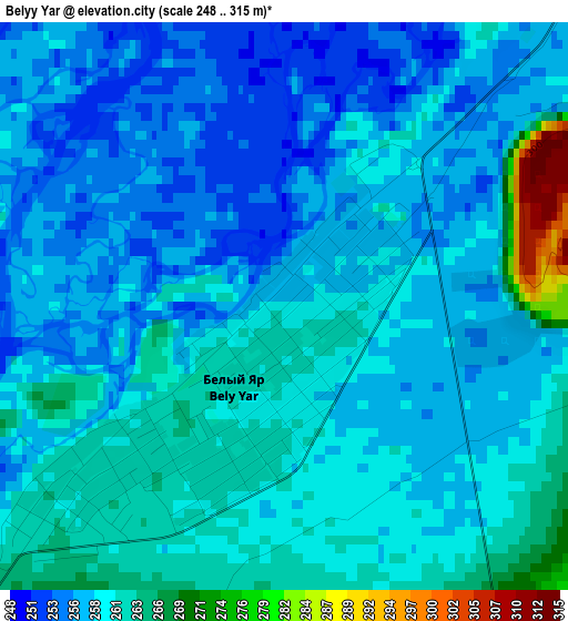
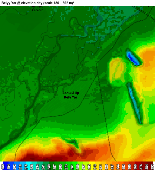
Below is the Elevation map of Belyy Yar, which displays elevation range with different colors. Scale of the first map is from 248 to 315 m (814 to 1033 ft) with average elevation of 259.1 meters (=850 ft) [note 1]
These maps also provides idea of topography and contour of this city, they are displayed at different zoom levels. More info about maps, scale and edge coordinates you can find below images.
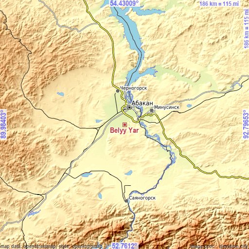
| \ | Map #1 | Map #2 | Topo.Map |
| Scale [m] | 248..315 m | 186..392 m | × |
| Scale [ft] | 814..1033 ft | 610..1286 ft | × |
| Average | 259.1 m = 850 ft | 273.3 m = 897 ft | × |
| Width | 5.8 km = 3.6 mi | 11.6 km = 7.2 mi | 185.6 km = 115.3 mi |
| Height | 5.8 km = 3.6 mi | 11.6 km = 7.2 mi | 185.5 km = 115.3 mi |
| ↑Max Latitude | 53.629958° | 53.656009° | 54.43009° |
| Latitude at center | 53.60389° | 53.60389° | 53.60389° |
| ↓Min Latitude | 53.577806° | 53.551707° | 52.7612° |
| ← Min Longitude | 91.346335° | 91.302389° | 89.98403° |
| Longitude center | 91.39028° | 91.39028° | 91.39028° |
| →Max Longitude | 91.434225° | 91.478171° | 92.79653° |
Nearby cities:
Cities around Belyy Yar sort by population:
• Abakan elevation 248 m
12.7 km,  11°
11°
• Minusinsk 251 m
22.9 km,  58°
58°
• Chernogorsk 279 m
25.4 km,  344°
344°
• Sayanogorsk 320 m
57.4 km,  179°
179°
• Shushenskoye 278 m
47.6 km,  130°
130°
• Ust’-Abakan 238 m
25.9 km,  0°
0°
• Beya 442 m
68.9 km,  207°
207°
• Mayna 317 m
66.7 km,  174°
174°
• Sayansk 434 m
68.8 km,  28°
28°
• Podsineye 251 m
11.8 km,  54°
54°
• Zelënyy Bor 269 m
15 km,  82°
82°
• Il’ichevo 280 m
46.8 km,  140°
140°
Multilingual:
 En español:
Belyy Yar elevación 258 m.
 En France:
Belyy Yar élévation 258 m.
 Auf Deutsch:
Belyy Yar höhe über dem Meeresspiegel ist 258 m.

Sources and notes:
- [note 1] Map square and city borders are not equal. Map elevation data is calculated only from area inside that square.
- [src 1] Elevation data from geonames database provided with same terms of usage.
- [src 2] The elevation map of Belyy Yar is generated using elevation data from NASA's 3 arcsec (90m) resolution SRTM data.
- [src 3] Base (background) map © OpenStreetMap contributors tiles are generated by Geofabrik and OpenTopoMap.
Copyright & License:
This Belyy Yar Elevation Map is licensed under CC BY-SA. You may reuse any part from this page, if you give a proper credit by linking to this URL:
 More info on terms of use page.